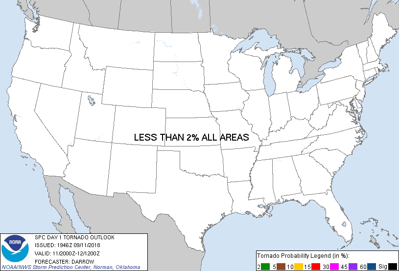
Probability of a tornado within 25 miles of a point. Hatched Area: 10% or greater probability of EF2 - EF5 tornadoes within 25 miles of a point.
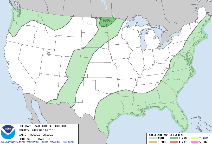
Day 1 Tornado Risk
Area (sq. mi.)
Area Pop.
Some Larger Population Centers in Risk Area
No Risk Areas Forecast
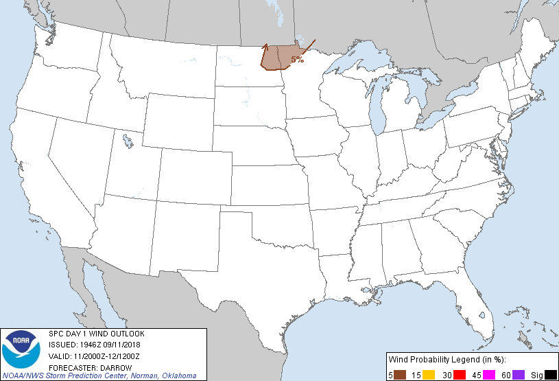
Probabilistic Damaging Wind Graphic
Probability of damaging thunderstorm winds or wind gusts of 50 knots or higher within 25 miles of a point. Hatched Area: 10% of greater probability of wind gusts 65 knots or greater within 25 miles of a point.
Day 1 Wind Risk
Area (sq. mi.)
Area Pop.
Some Larger Population Centers in Risk Area
5 %
21,821
199,946
Grand Forks, ND...Grafton, ND...
Probabilistic Large Hail Graphic
Probability of hail 1" or larger within 25 miles of a point. Hatched Area: 10% or greater probability of hail 2" or larger within 25 miles of a point.
Day 1 Hail Risk
Area (sq. mi.)
Area Pop.
Some Larger Population Centers in Risk Area
5 %
21,728
198,396
Grand Forks, ND...Grafton, ND...
   SPC AC 111946

   Day 1 Convective Outlook
   NWS Storm Prediction Center Norman OK
   0246 PM CDT Tue Sep 11 2018

   Valid 112000Z - 121200Z

   ...THERE IS A MARGINAL RISK OF SEVERE THUNDERSTORMS ACROSS THE
   NORTHERN PLAINS...

   ...SUMMARY...
   Isolated large hail and damaging winds will be possible between 5 to
   9 pm in northeast North Dakota and northwest Minnesota.

   ...Discussion...

   Only a minor change to the 1630z outlook is warranted.

   Weak convection has recently developed across south-central MB along
   advancing cold front. This activity appears to be along/just behind
   the wind shift as frontal ascent is likely required due to surface
   parcels not yet reaching convective temperatures. As this activity
   matures there is some risk for southwestward development into ND.
   Earlier thoughts regarding this scenario continue.

   ..Darrow.. 09/11/2018

   .PREV DISCUSSION... /ISSUED 1129 AM CDT Tue Sep 11 2018/

   ..Northeast ND and northwest MN...
   A cold front over central ND will march east and reach the Red River
   Valley by early evening, as a low-amplitude shortwave trough crosses
   central Manitoba. While stronger/deeper forcing for ascent is
   expected to remain north of the international border, a narrow zone
   of low-level convergence and minimal convective inhibition along the
   front in northeast ND should result in isolated storm development
   around 5 pm.

   Gradual low-level moistening has occurred the past two days ahead of
   the front across the Dakotas with mean mixing ratios of around 12
   g/kg sampled by the 12Z Aberdeen sounding. These lower 60s
   boundary-layer dew points and robust surface heating, beneath the
   elevated mixed layer, will support moderate buoyancy with MLCAPE of
   1500-2500 J/kg. While hodographs will not be enlarged, effective
   bulk shear of 30-35 kt will support transient mid-level updraft
   rotation. A mix of isolated large hail and strong gusts are possible
   into northwest MN before convection weakens after sunset.

   CLICK TO GET WUUS01 PTSDY1 PRODUCT

   NOTE: THE NEXT DAY 1 OUTLOOK IS SCHEDULED BY 0100Z