Fayetteville, NC...Greenville, NC...Rocky Mount, NC...Wilson, NC...Myrtle Beach, SC...
Probabilistic Damaging Wind Graphic
Probability of damaging thunderstorm winds or wind gusts of 50 knots or higher within 25 miles of a point. Hatched Area: 10% of greater probability of wind gusts 65 knots or greater within 25 miles of a point.
Day 1 Wind Risk
Area (sq. mi.)
Area Pop.
Some Larger Population Centers in Risk Area
No Risk Areas Forecast
Probabilistic Large Hail Graphic
Probability of hail 1" or larger within 25 miles of a point. Hatched Area: 10% or greater probability of hail 2" or larger within 25 miles of a point.
Day 1 Hail Risk
Area (sq. mi.)
Area Pop.
Some Larger Population Centers in Risk Area
No Risk Areas Forecast
SPC AC 140542
Day 1 Convective Outlook
NWS Storm Prediction Center Norman OK
1242 AM CDT Fri Sep 14 2018
Valid 141200Z - 151200Z
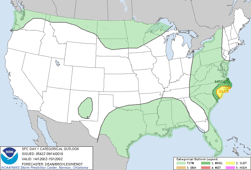
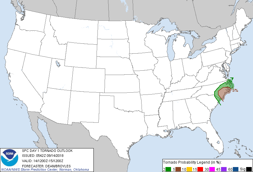
...THERE IS A SLIGHT RISK OF SEVERE THUNDERSTORMS FOR EASTERN NORTH
CAROLINA...
...SUMMARY...
A few tornadoes are possible across eastern North Carolina as
Hurricane Florence continues to impact the region today into
tonight.
...Coastal Carolinas -- Hurricane Florence...
A long-duration, relatively low-magnitude tornado threat is expected
to continue across portions of eastern NC today into tonight.
Hurricane Florence is forecast to be approaching the NC coast near
Wilmington by 12Z this morning, with a slow west-southwestward
movement expected into northeast SC by Saturday morning. While
weakening of the wind field is expected once landfall occurs, very
strong low-level flow will contribute to 0-1 km SRH of 300-500 m2/s2
across portions of eastern NC. With minimal diabatic heating
expected, buoyancy will largely be driven by low-level moisture
content, with MLCAPE of 500-1000 J/kg possible in areas where
surface dewpoints are in the mid-upper 70s F. The most favorable
juxtaposition of surface theta-e and low-level shear is expected in
the northeast quadrant of the circulation, which should largely
remain over coastal regions of east-central and southeast NC, where
5% tornado probabilities are included with this outlook.
...Central/northern Minnesota...
Scattered thunderstorms are expected tonight across portions of
central/northern MN, as low-level warm advection gradually increases
to the north of a nearly stationary front. MUCAPE of 1000-2000 J/kg
and effective shear of 30-40 kt may support updraft organization
with some potential for hail, though uncertainty remains regarding
the sustenance of discrete convective modes that would be more
favorable for a severe hail threat. No probabilities have been
included for this scenario at this time, but some may eventually be
needed depending on observational and guidance trends later today.
..Dean/Broyles/Wendt.. 09/14/2018
CLICK TO GET WUUS01 PTSDY1 PRODUCT
NOTE: THE NEXT DAY 1 OUTLOOK IS SCHEDULED BY 1300Z