SPC AC 241255
Day 1 Convective Outlook
NWS Storm Prediction Center Norman OK
0755 AM CDT Mon Sep 24 2018
Valid 241300Z - 251200Z
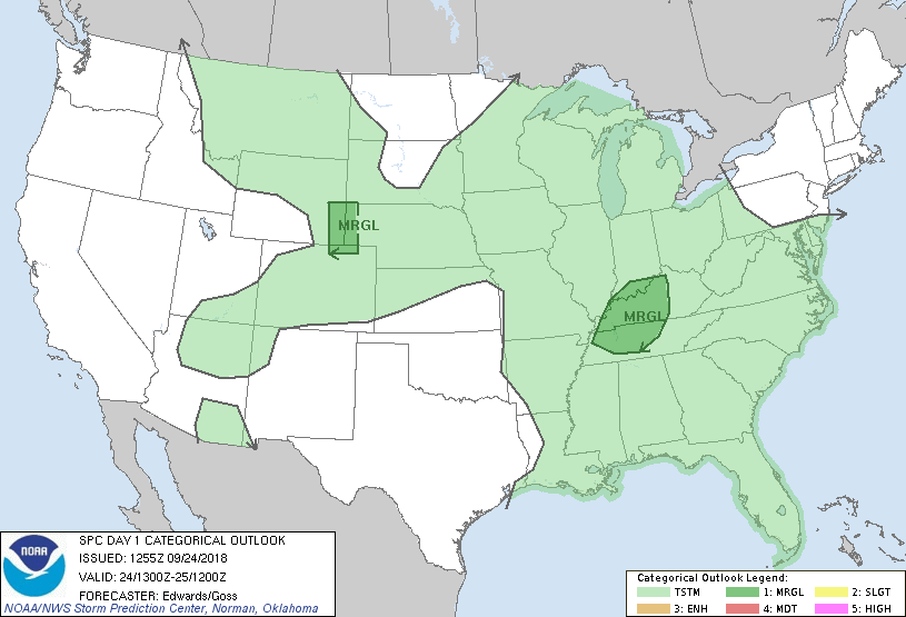
...THERE IS A MARGINAL RISK OF SEVERE THUNDERSTORMS ACROSS PARTS OF
THE TENNESSEE AND OHIO VALLEYS...AND THE NORTH-CENTRAL HIGH
PLAINS...
...SUMMARY...
Isolated severe storms are possible across parts of the Tennessee
and Ohio Valleys, and the north-central High Plains.
...Synopsis...
The dominant upper-air feature for this period will be a
synoptic-scale trough bracketed by broadly cyclonic flow, moving
eastward across the northern/central Rockies and adjoining High
Plains. This trough initially was evident in moisture-channel
imagery from northern SK across central MT, southern ID, northern
NV, and north-central CA. A series of mainly low-amplitude
shortwaves and vorticity maxima should pivot through the trough at
substantially faster translational speed than the trough itself. By
the end of the period, the trough should reach western MB, western
Dakotas, Nebraska Panhandle, eastern CO, and northern NM.
Meanwhile, a diffuse southern-stream trough -- now located over
portions of western IL, AR and east TX -- should eject northeastward
and weaken further, with embedded, convectively induced/enhanced
vorticity maxima likely becoming the dominant components.
At the surface, the 11Z analysis showed a wavy, quasistationary and
gradually weakening frontal zone from eastern NC to middle TN,
through a weak low over the Arklatex region related to the mid/upper
perturbation, then across south-central TX. Frontolysis should
continue over the lower/middle Mississippi and lower Ohio Valleys
through the period as the remnants of the low-level baroclinic zone
shift northward. Another low was drawn over west-central MN, with
cold front southwestward across central NE to east-central CO. By
00Z this front should reach the MN Arrowhead, northwestern IA,
southwestern KS, and northeastern NM. By 12Z it should reach
central/eastern Lake Superior, northwestern WI, central IA, central
KS, and east-central NM. Isolated to widely scattered thunderstorms
may form along this front this afternoon and evening over parts of
MN and western WI, but should be subsevere given lack of more robust
moisture/buoyancy.
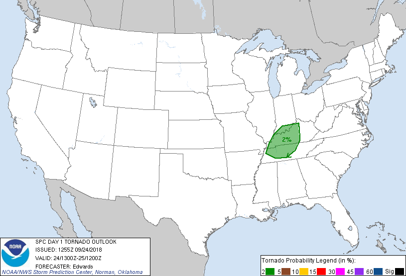
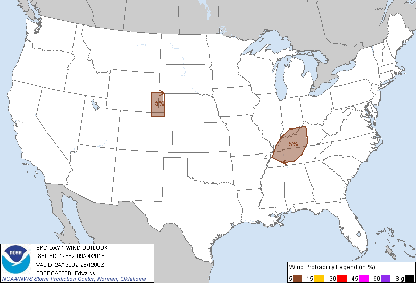
...TN/OH Valley region...
Scattered thunderstorms are expected to move northeastward across
the region today, in and near the outlook area. The main hazard
arises from heavy rain, per the moderate risk discussed in the
latest HPC excessive-rainfall outlook. However, an isolated
damaging gust or a brief tornado with an embedded supercell cannot
be ruled out.
Rich low-level moisture, with PW commonly in excess of 2 inches and
surface dew points mid-60s to low-70s F, will remain common over the
area, along with low LCLs and weak midlevel lapse rates that will
limit MLCAPE to the 500-1200 J/kg range in most areas. Low-level
shear is forecast to remain favorable beneath a 35-45-kt
southwesterly LLJ, with some forecast hodographs showing effective
SRH in the 200-350 J/kg range. Specific foci for convection in this
regime appear ambiguous, but are likely to involve:
1. Subtle low-level confluence/convergence axes, offering
sufficient lift for convection amidst weak MLCINH, and
2. Mesobeta- to smaller-scale baroclinic zones set up by outflow
and differential heating behind a swath of convection crossing this
region this morning.
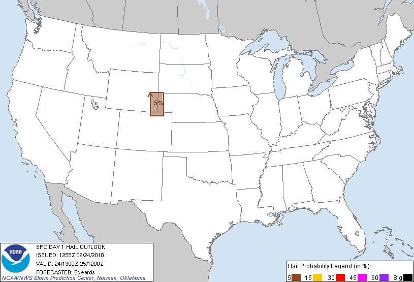
...North-central High Plains...
Widely scattered thunderstorms are expected to develop this
afternoon over the foothills and High Plains from northeastern CO to
southeastern MT and southwestern ND, mainly posing the risk of brief
and isolated strong gusts or small hail. The environment for
activity over much of this corridor will lack either favorable
buoyancy, inflow-layer moisture or vertical shear.
However, one area of marginal but sufficient parameter-space
juxtaposition supporting isolated severe hail/gusts appears to be
over portions of southeastern WY, perhaps extending into the western
NE Panhandle and adjoining northeastern CO. Over this region,
post-frontal easterlies will converge upslope and into an inverted
surface trough that already is apparent behind the front, in the
I-25 corridor of northern CO and southeastern WY. A corridor of
diurnal heating may develop behind a swath of morning clouds/precip
now apparent across this area, and beneath steep lapse rates in the
700-500-mb layer related to large-scale ascent near the mid/upper
trough. This, along with surface dew points generally mid-upper 40s
F, should lead to MLCAPE near 500 J/kg. Forecast wind profiles show
weak near-surface winds, but with enough easterly component to
enhance storm-relative flow in the boundary layer, beneath a
45-60-kt cyclonic flow belt in the 300-500-mb layer. Strong
deep-layer speed shear with effective-shear magnitudes of 45-55 kt
will support at least transient supercell potential, and the risk
for isolated damaging gusts or large hail.
..Edwards/Goss.. 09/24/2018
CLICK TO GET WUUS01 PTSDY1 PRODUCT
NOTE: THE NEXT DAY 1 OUTLOOK IS SCHEDULED BY 1630Z
|