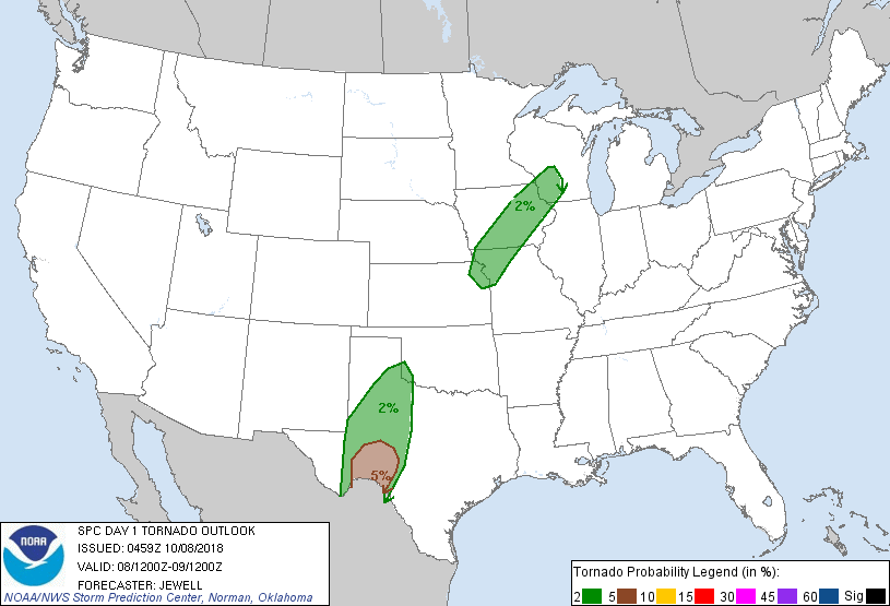
Oklahoma City, OK...Kansas City, MO...Omaha, NE...Wichita, KS...Des Moines, IA...
Probabilistic Tornado Graphic
Probability of a tornado within 25 miles of a point. Hatched Area: 10% or greater probability of EF2 - EF5 tornadoes within 25 miles of a point.
Day 1 Tornado Risk
Area (sq. mi.)
Area Pop.
Some Larger Population Centers in Risk Area
5 %
16,784
68,984
Del Rio, TX...
2 %
98,824
5,463,847
Kansas City, MO...Lubbock, TX...Des Moines, IA...Overland Park, KS...Kansas City, KS...
Probabilistic Damaging Wind Graphic
Probability of damaging thunderstorm winds or wind gusts of 50 knots or higher within 25 miles of a point. Hatched Area: 10% of greater probability of wind gusts 65 knots or greater within 25 miles of a point.
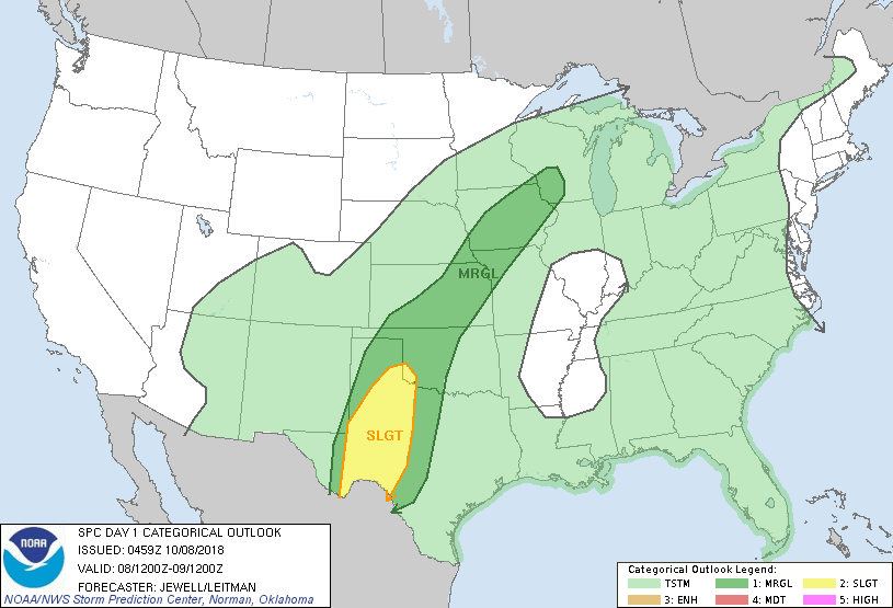
SPC AC 080459
Day 1 Convective Outlook
NWS Storm Prediction Center Norman OK
1159 PM CDT Sun Oct 07 2018
Valid 081200Z - 091200Z
...THERE IS A SLIGHT RISK OF SEVERE THUNDERSTORMS ACROSS MUCH OF
WESTERN TEXAS AND FAR SOUTHWEST OKLAHOMA...
...SUMMARY...
Multiple rounds of thunderstorms are expected to develop across the
southern and central Plains Monday. The greatest chance for severe
thunderstorms will exist from the Texas South Plains into the Big
Bend region. A few strong storms are also possible from eastern
Kansas into into Iowa and southwest Wisconsin.
...Synopsis...
A large, amplified upper trough will exist along the length of the
Rockies, with an upper ridge centered just off the Mid Atlantic
coast. Substantial southerly winds will thus exist across the
Plains, with increasing lift Monday night over the Southern Plains
as a shortwave trough and midlevel speed max develop into west TX.
To the north, a leading disturbance is expected to enhance lift from
the central Plains into the upper Mississippi Valley during the day.
In the low levels, a surface trough will extend from a weak low near
the NM/TX border northeastward across IA and into WI. South of this
front, a very moist air mass will exist, with mid to upper 60s F
dewpoints common. Multiple bouts of thunderstorms will occur
throughout the period across much of the Plains, with the most
likely area of severe weather across western Texas.
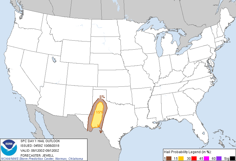
...Southwest TX into western OK...
Scattered thunderstorms will be ongoing across parts of the TX
Panhandle and northwest TX into western OK Monday morning, and
isolated severe activity cannot be ruled out as little if any
capping inversion will be present, and shear profiles will be
sufficient. Additional afternoon storms are likely to form along the
wind shift near the NM/TX border, and a few supercells will be
possible as low level winds will veer with height in addition to
increasing speed shear aloft. Storms will become most numerous after
00Z, coincident with the stronger lift with the shortwave trough.
Damaging winds and hail are most likely, but a tornado could occur
as well as storms form into a linear MCS and approach west-central
TX by Tuesday morning. Should cellular activity develop ahead of the
MCS toward the Edwards Plateau, a tornado or two would be possible.
...Eastern KS northeastward across IA and into southwest WI...
Rain and thunderstorms should be ongoing from northeast KS across IA
into WI, in a zone of low-level warm advection associated with a 40
kt southwesterly low-level jet. Some northward progression of the
warm front is expected, allowing destabilization into IA and WI.
Although existing precipitation may play a role in the effective
frontal position, at least isolated strong to severe storms are
possible during the afternoon. Low-level shear will remain favorable
for storm rotation, and a brief/weak tornado cannot be ruled out.
...Southern FL including the Keys...
TC Michael is forecast to move into the Gulf of Mexico Monday night
into Tuesday, but will remain well west of FL. Still, relatively
strong easterlies will develop in the low-levels across the region,
with bands of thunderstorms expected to affect southern FL. Forecast
soundings show modest effective SRH values approaching 100 m2/s2,
suggesting weak rotation is possible in some of the storms. However,
the severe threat appears low, with weak winds aloft and marginal
instability.
..Jewell/Leitman.. 10/08/2018
CLICK TO GET WUUS01 PTSDY1 PRODUCT
NOTE: THE NEXT DAY 1 OUTLOOK IS SCHEDULED BY 1300Z