Probability of a tornado within 25 miles of a point. Hatched Area: 10% or greater probability of EF2 - EF5 tornadoes within 25 miles of a point.
Day 1 Tornado Risk
Area (sq. mi.)
Area Pop.
Some Larger Population Centers in Risk Area
No Risk Areas Forecast
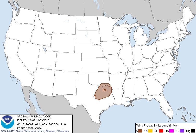
Probabilistic Damaging Wind Graphic
Probability of damaging thunderstorm winds or wind gusts of 50 knots or higher within 25 miles of a point. Hatched Area: 10% of greater probability of wind gusts 65 knots or greater within 25 miles of a point.
Probability of hail 1" or larger within 25 miles of a point. Hatched Area: 10% or greater probability of hail 2" or larger within 25 miles of a point.
Day 1 Hail Risk
Area (sq. mi.)
Area Pop.
Some Larger Population Centers in Risk Area
No Risk Areas Forecast
SPC AC 031940
Day 1 Convective Outlook
NWS Storm Prediction Center Norman OK
0240 PM CDT Sat Nov 03 2018
Valid 032000Z - 041200Z
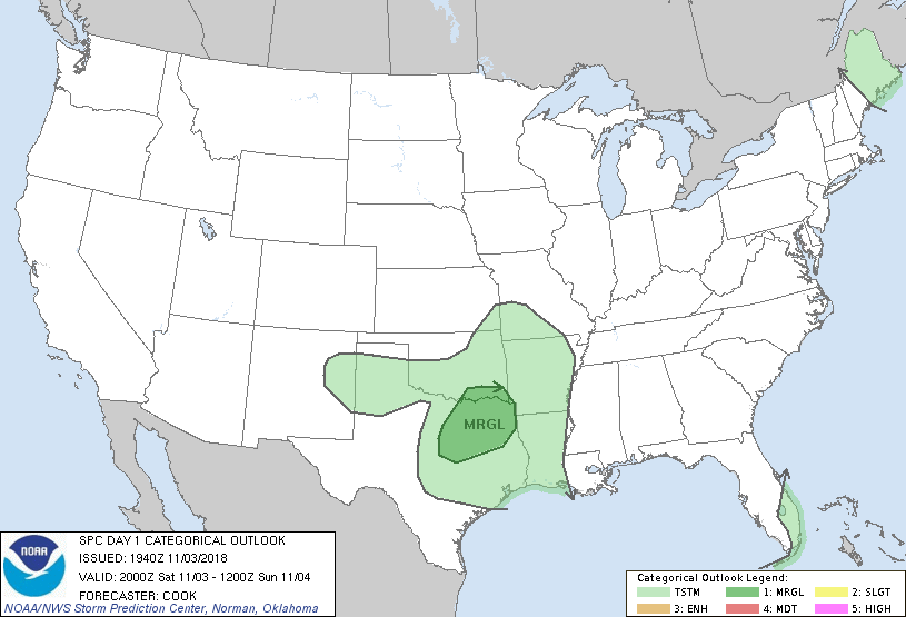
...THERE IS A MARGINAL RISK OF SEVERE THUNDERSTORMS ACROSS
SOUTHEASTERN OKLAHOMA AND NORTHERN/NORTHEASTERN TEXAS...
...SUMMARY...
Thunderstorms with isolated strong wind gusts will be possible this
evening into early tonight across northeast Texas and vicinity.
...20Z Outlook Update...
The overall forecast philosophy remains on track, with convection
expected to increase along and just behind a southward-surging cold
front across Oklahoma and north Texas. Heating/moistening ahead of
the frontal boundary will result in linear convection capable of
isolated damaging wind gusts - primarily after 00Z. Other isolated
and diurnally driven thunderstorms will impact areas farther west
(west Texas and adjacent New Mexico). Prefrontal convection will
likely increase late tonight across portions of Louisiana and
southern Arkansas.
..Cook.. 11/03/2018
.PREV DISCUSSION... /ISSUED 1122 AM CDT Sat Nov 03 2018/
...Synopsis...
An intense midlevel shortwave trough and deepening surface cyclone
will move northeastward over New England today, with some lingering
threat for low-topped convection (primarily into Maine this
afternoon). In the wake of this system, a cold front is in the
process of stalling across south FL and the Gulf of Mexico. Farther
west, a midlevel shortwave trough over the southern High Plains will
progress eastward over the Red River Valley of TX/OK through
tonight. Surface cyclogenesis in advance of the midlevel trough
will draw a modifying air mass northward across TX, where
boundary-layer dewpoints will increase to the 60s along the coast
and mid-upper 50s into north TX by this evening.
The combination of surface heating and low-level moistening will
contribute to weak near-surface-based buoyancy into extreme southern
OK and north TX immediately in advance of a surface cold front. A
narrow band of low-topped convection is expected to form this
evening along the front, and subsequently spread
eastward/southeastward overnight toward AR/LA. Isolated
strong/damaging gusts will be possible this evening into early
tonight with this band of frontal thunderstorms in the vicinity of
northeast TX, though any severe threat should diminish late tonight
given only weak buoyancy and the elevated nature of the convection.
CLICK TO GET WUUS01 PTSDY1 PRODUCT
NOTE: THE NEXT DAY 1 OUTLOOK IS SCHEDULED BY 0100Z