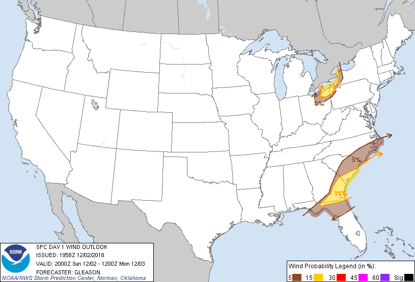
Probability of damaging thunderstorm winds or wind gusts of 50 knots or higher within 25 miles of a point. Hatched Area: 10% of greater probability of wind gusts 65 knots or greater within 25 miles of a point.
Probability of hail 1" or larger within 25 miles of a point. Hatched Area: 10% or greater probability of hail 2" or larger within 25 miles of a point.
Day 1 Hail Risk
Area (sq. mi.)
Area Pop.
Some Larger Population Centers in Risk Area
No Risk Areas Forecast
SPC AC 021958
Day 1 Convective Outlook
NWS Storm Prediction Center Norman OK
0158 PM CST Sun Dec 02 2018
Valid 022000Z - 031200Z
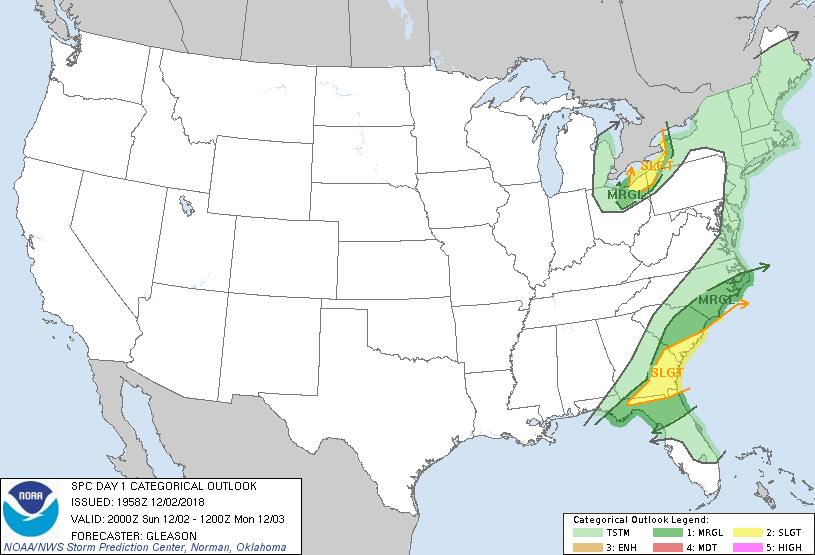
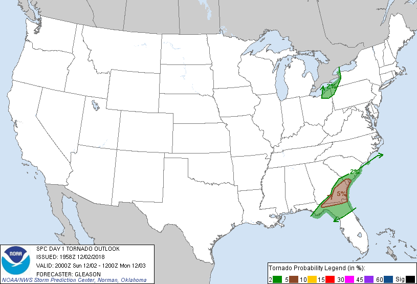
...THERE IS A SLIGHT RISK OF SEVERE THUNDERSTORMS ACROSS PARTS OF
THE SOUTHEAST STATES...AND ALONG THE SOUTHEAST SHORES OF LAKE
ERIE...
...SUMMARY...
Isolated severe thunderstorms will remain possible today from the
Florida Panhandle to the eastern Carolinas, and near the southeast
shore of Lake Erie.
...20Z Update...
Severe probabilities have been trimmed behind an ongoing broken line
of thunderstorms across southern GA and the FL Panhandle, as
additional convective development behind this activity appears
unlikely. Isolated tornadoes and strong/damaging winds will remain
possible through this evening across this region as 1500-2500 J/kg
of MLCAPE and 40-50 kt of effective bulk shear encourage updraft
rotation with supercells embedded within and occurring ahead the
line.
No changes have been made to the Marginal/Slight risk areas for
parts of OH/PA/NY. Although surface dewpoints have mixed generally
into the lower to mid 40s across this area, the potential still
exists for low-topped thunderstorms producing strong to locally
damaging winds due to the enhanced south-southwesterly flow noted on
recent VWPs from KCLE.
..Gleason.. 12/02/2018
.PREV DISCUSSION... /ISSUED 1025 AM CST Sun Dec 02 2018/
...Southeast...
Scattered thunderstorms are ongoing today along a baroclinic zone
from the western FL Panhandle into southern GA and southern SC.
Ample low level moisture and shear is present along the boundary,
but organized rotating storms are only occasionally intensifying to
severe limits. This trend will likely persist through the
afternoon, with the potential for damaging wind gusts and a few
tornadoes in the strongest cells. Recent model guidance suggests a
lessening severe risk farther northeast into parts of NC and central
SC.
...OH/PA/NY...
Water vapor loops shows a progressive shortwave trough over
west-central IN. This system will move quickly northeastward into
OH this afternoon. Southerly low level winds are helping to
transport 50s dewpoints into the upper OH Valley, where full
sunshine and steepening low level lapse rates will yield afternoon
MLCAPE values of as high as 500 J/kg. Despite the weak
thermodynamic environment, forecast soundings show strong wind
fields and an environment favorable for bowing/rotating storms.
Lightning may be sparse with this activity due to a shallow CAPE
layer, but the strongest cells could produce gusty/damaging wind
gusts. Have opted to add a small SLGT risk to the shores of Lake
Erie, where 12z CAM solutions offer the highest confidence of
convection this afternoon.
CLICK TO GET WUUS01 PTSDY1 PRODUCT
NOTE: THE NEXT DAY 1 OUTLOOK IS SCHEDULED BY 0100Z