Houston, TX...Austin, TX...Memphis, TN...Oklahoma City, OK...New Orleans, LA...
SPC AC 051726
Day 2 Convective Outlook
NWS Storm Prediction Center Norman OK
1226 PM CDT Thu Apr 05 2018
Valid 061200Z - 071200Z
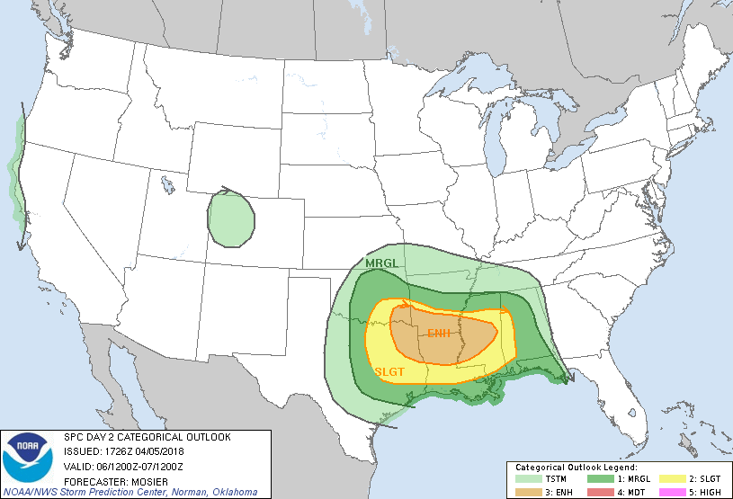
...THERE IS AN ENHANCED RISK OF SEVERE THUNDERSTORMS ACROSS PORTIONS
OF SOUTHEAST OK...NORTHEAST TX...SOUTHERN AR...NORTHERN LA...AND
CENTRAL MS...
...THERE IS A SLIGHT RISK OF SEVERE THUNDERSTORMS FROM EAST TX AND
SOUTHEAST OK INTO WESTERN AL...
...THERE IS A MARGINAL RISK OF SEVERE THUNDERSTORMS OVER PORTIONS OF
THE SOUTHERN PLAINS AND LOWER MS VALLEY...
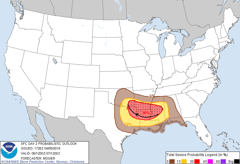
...SUMMARY...
Threat for strong to severe storms capable of mainly large hail and
damaging wind gusts, but possibly a few tornadoes is expected Friday
afternoon and overnight over a portion of the Southern Plains and
lower Mississippi Valley.
...Synopsis...
Broadly cyclonic flow is expected to persist across the CONUS on
Friday with a strong shortwave trough expected to pivot through the
Upper Great Lakes and Northeast States and adjacent portion of
Quebec. Farther south, a pair of more subtle shortwave troughs will
likely move across northern portions of the Southern Plains. The
first is anticipated very early in the period while the second will
follow closely behind during the afternoon.
At the same time, a surface low will deepen across the southern High
Plains while a strong cold front sweeps southward/southeastward. By
00Z Saturday, this cold front is expected to extend from a low near
the confluence of the MS and OH rivers southwestward into the TX Big
Country and then back northwestward into northeast NM. Moisture
advection is expected across the southern Plains and lower MS Valley
throughout the day, with numerous thunderstorms, some severe,
expected along and ahead of the front as it moves southeastward.
...Southern Plains into the Lower MS Valley...
Showers and thunderstorms will likely be ongoing north of the
sharpening warm frontal zone initially extending from central OK
southeastward through the Ark-La-Tex. This activity is expected to
be elevated but mid-level lapse rates are steep enough to support
isolated hail. General expectation is for this activity to persist
largely in place Friday morning before eventually becoming more
rooted at the surface and propagating southeastward along the warm
front. The second shortwave trough mentioned in the synopsis will
likely be the impetus for this additional strengthening and
organizing of the initial convection. The convective line may
initially be slow to organize but strengthening mid-level
northwesterly flow as well as increasing low-level flow will act to
enhance vertical shear, encouraging upscale growth into a well
organized MCS. Anticipated well organized nature of this convective
system is expected to support damaging wind gusts, some potentially
significant, across the lower MS Valley. Embedded
mesovorticies/tornadoes are also possible within this line,
particularly across the northern end of the line where mesolow
development is favored. However, confidence regarding the location
of these mesoscale processes is currently low.
Warmer temperatures aloft will likely suppress convection across
most of central and east TX until the cold front moves through
during the evening and overnight. Steep mid-level lapse rates,
favorable low-level moisture (i.e. dewpoints the mid-60s), and
adequate vertical shear (around 50 kt from 0-6 km) will exist
throughout the region, supporting the potential for severe hail.
Some isolated very large hail is possible with the initial
development, although confidence in occurrence is mitigated somewhat
by the quick transition to a linear mode.
..Mosier.. 04/05/2018
CLICK TO GET WUUS02 PTSDY2 PRODUCT
NOTE: THE NEXT DAY 2 OUTLOOK IS SCHEDULED BY 0600Z