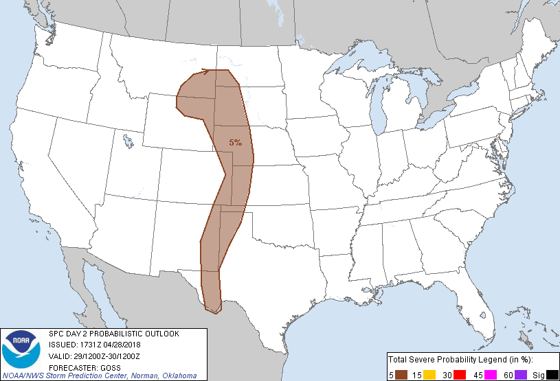
Amarillo, TX...Rapid City, SD...Roswell, NM...Clovis, NM...Hobbs, NM...
Probabilistic Graphic
Probability of severe weather within 25 miles of a point. Hatched Area: 10% or greater probability of significant severe within 25 miles of a point.
Day 2 Prob. Risk
Area (sq. mi.)
Area Pop.
Some Larger Population Centers in Risk Area
5 %
224,234
1,554,859
Amarillo, TX...Rapid City, SD...Roswell, NM...Clovis, NM...Hobbs, NM...
SPC AC 281731
Day 2 Convective Outlook
NWS Storm Prediction Center Norman OK
1231 PM CDT Sat Apr 28 2018
Valid 291200Z - 301200Z
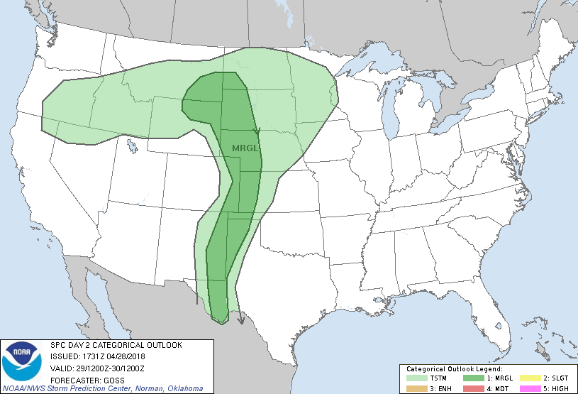
...THERE IS A MARGINAL RISK OF SEVERE THUNDERSTORMS ACROSS THE HIGH
PLAINS REGION...
...SUMMARY...
Widely-scattered strong to locally severe storms capable hail and
possibly gusty winds are expected across the High Plains from
southeast Montana southward to the Big Bend of west Texas.
...Synopsis...
A slowly progressive upper pattern -- featuring troughs over the
eastern and western U.S. flanking a central U.S. ridge -- is progged
across the U.S. on Sunday. At the surface, a cold front will
continue progressing across the western states ahead of the upper
system, while a lee trough remains established over the High Plains.
With time, the cold front will overtake northern portions of the
lee trough, and continue progressing into the Dakotas/western
Nebraska through the end of the period.
...The High Plains...
Large-scale ascent -- focused near a surface lee trough over the
High Plains -- will increase as mid-level heights fall ahead of the
slowly advancing western upper trough. This will result in
conditions supportive for convective initiation evolving through the
afternoon, as gradual/modest airmass destabilization occurs despite
scant low-level moisture.
With diurnal surface heating beneath steepening mid-level lapse
rates supporting 1000 to 1500 J/kg high-based mixed-layer CAPE
through peak heating, scattered showers and isolated thunderstorms
should develop, from the northeast Wyoming/southeast Montana
vicinity southward across the High Plains.
Along with modest but sufficient instability, marginal shear will
likely be present across the region -- sufficient for
semi-organized, possibly weakly rotating storms. As such, potential
for hail -- and possibly a damaging gust in a few locales -- is
evident from the strongest high-based updrafts. It would appear
that the CAPE/shear combination may be maximized over the northern
High Plains area -- i.e. northern portions of the marginal risk.
However, confidence with respect to coverage of severe storms
precludes upgrade to 15%/slight risk at this time.
Convection will have a strong diurnal peak through late afternoon,
diminishing through/after sunset as the boundary layer
cools/stabilizes rapidly.
...MAXIMUM RISK BY HAZARD...
Tornado: <2% - None
Wind: 5% - Marginal
Hail: 5% - Marginal
..Goss.. 04/28/2018
CLICK TO GET WUUS02 PTSDY2 PRODUCT
NOTE: THE NEXT DAY 2 OUTLOOK IS SCHEDULED BY 0600Z