SPC AC 130455
Day 2 Convective Outlook
NWS Storm Prediction Center Norman OK
1155 PM CDT Sat May 12 2018
Valid 141200Z - 151200Z
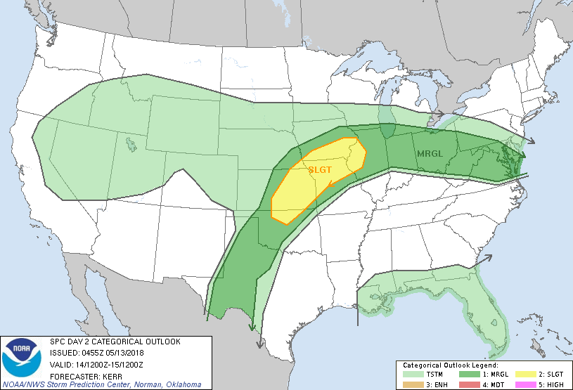
...THERE IS A SLIGHT RISK OF SEVERE THUNDERSTORMS MONDAY AFTERNOON
AND EVENING ACROSS THE LOWER MISSOURI/MIDDLE MISSISSIPPI VALLEY
REGION AND ADJACENT CENTRAL PLAINS...
...SUMMARY...
Severe thunderstorms, accompanied by the risk for large hail and
potentially damaging wind gusts, are possible Monday afternoon and
evening across parts of lower Missouri/middle Mississippi Valley
region and adjacent central Plains. Other strong storms may be
accompanied by at least some severe risk across parts of the Ohio
Valley into Mid Atlantic region, and across the southern high
Plains.
...Synopsis...
Blocking near/just inland of the U.S. Pacific coast will maintain a
split in the westerlies emanating from the Pacific through this
period. Models do continue to indicate considerable weakening of a
broad closed low centered over the Great Basin, but broad southern
branch troughing is forecast to persist across much of the Southwest
and southern Rockies. At the same time, broad downstream ridging
appears likely to hold firm across the central Plains and
middle/lower Missouri Valley into the Ohio Valley. This is more
unclear across the upper Ohio Valley into northern Mid Atlantic
region, where some suppression is possible, as a vigorous short wave
impulse emanating from the Arctic latitudes digs in phase with
northern branch, across and southeast of Hudson Bay. In lower
latitudes, a mid-level low may continue to evolve within the
subtropical westerlies, over the northeastern Gulf of Mexico.
In lower levels, the Arctic impulse likely will be accompanied by a
significant cold front which may approach the upper Great Lakes
region by late Monday night. Farther south, a remnant frontal zone,
reinforced in areas by convective outflow, is expected to remain
generally quasi-stationary. This probably will roughly align with
the northern periphery of the southern branch ridging, along which a
lingering plume of elevated mixed-layer air may continue to
contribute to steep lower/mid tropospheric lapse rates. It appears
that this environment, coupled with lower/mid 60s+ surface dew
points, will contribute to corridors of moderately large CAPE
near/south of the front and along/east of the southern Plains
dryline by peak heating Monday. Given this destabilization, it
still appears that deep layer shear, while not strong, may be
marginally sufficient to support potential for organizing storm
clusters. However, this may largely depend on forcing associated
with subtle perturbations progressing through the larger-scale
anticyclonic flow, which generally still remains uncertain.
...Lower Missouri/middle Mississippi Valleys/central Plains...
It seems, with at least some increasing confidence, that a low
amplitude mid-level wave (accompanied by 30-40 kt flow in the
700-500 mb layer) will emerge from the Southwestern troughing and
progress across the region favorably timed with peak boundary layer
destabilization. This may include CAPE on the order of 3000+ J/kg.
As large-scale forcing for ascent aids the initiation of storms,
multiple thunderstorm clusters may evolve and perhaps eventually
merge, while tending to propagate eastward and southeastward through
Monday evening. This activity probably will pose a severe hail
risk, at least initially, before the risk for strong surface gusts
becomes more prominent as activity grows upscale.
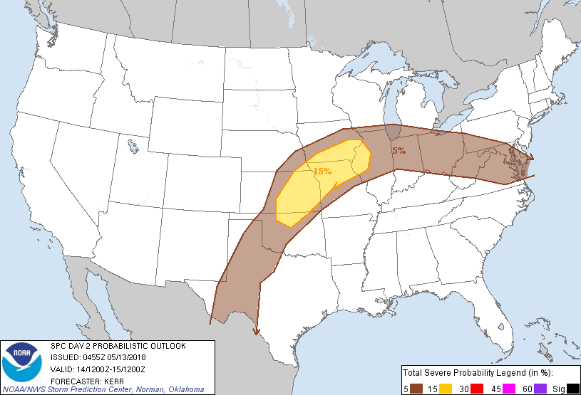
...MAXIMUM RISK BY HAZARD...
Tornado: 2% - Marginal
Wind: 15% - Slight
Hail: 15% - Slight
..Kerr.. 05/13/2018
CLICK TO GET WUUS02 PTSDY2 PRODUCT
NOTE: THE NEXT DAY 2 OUTLOOK IS SCHEDULED BY 1730Z