SPC AC 131728
Day 2 Convective Outlook
NWS Storm Prediction Center Norman OK
1228 PM CDT Sun May 13 2018
Valid 141200Z - 151200Z
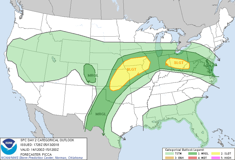
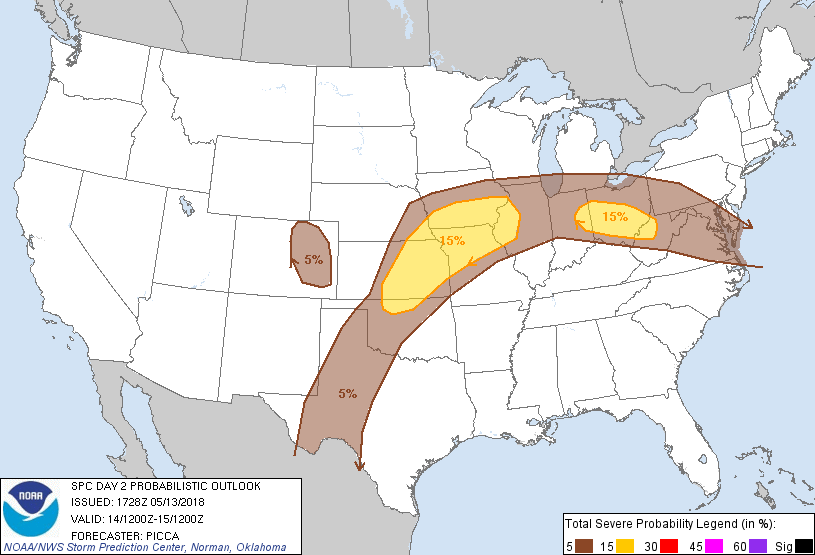
...THERE IS A SLIGHT RISK OF SEVERE THUNDERSTORMS FROM PARTS OF THE
SOUTHERN PLAINS TO THE MID MS VALLEY AND ACROSS PARTS OF THE OHIO
VALLEY...
...SUMMARY...
Severe thunderstorms, capable of damaging winds and large hail, will
be possible Monday afternoon and evening from parts of the southern
Plains northeastward to the mid Mississippi Valley. Elsewhere, a few
severe storms will be possible from the mid/upper Ohio Valley
eastward to the Mid-Atlantic. The main threat with these cells will
be damaging wind.
...Southern Plains to the mid Mississippi Valley...
Severe/convective evolution appears somewhat uncertain across
portions of the region on Monday. Within a regime of approximately
25-40 kt 500mb southwesterlies overlying the southern Plains and
Missouri Valley, several weak/convectively augmented impulses will
likely be transiting northeastward through the day. Focused
ascent/warm advection ahead of each of these impulses will likely
encourage convective initiation along both a dry line extending
southward from southern Kansas into western Oklahoma/Texas, as well
as a front extending to the northeast towards the Kansas City metro
area and points east/northeast. The strongest flow aloft (and
potential for greatest storm organization) will likely exist from
northeast Kansas to the mid Mississippi Valley. Furthermore, a nose
of focused warm advection will likely be placed in this zone as
well, such that scattered convection is expected by afternoon. In
turn, steep mid-level lapse rates (giving rise to moderate/strong
buoyancy) should yield a few multicell clusters, with embedded
supercell elements, primarily capable of damaging winds and large
hail near/south of the front. To its north, large hail will be the
primary threat.
With south/southwestward extent, decreasing flow aloft will likely
reduce storm organization. Nonetheless, favorable heating/lapse
rates should encourage a damaging wind threat with any deeper cores
during the afternoon/evening.
...Ohio Valley to the Mid Atlantic...
Considerable uncertainty also exists across this region on Monday.
It is likely that some residual convective system will be ongoing
across parts of Indiana and Ohio Monday morning, resulting from
overnight convection generating in northern Illinois. With the Ohio
Valley remaining on the edge of a plume of steep mid-level lapse
rates, any stronger surface-based convection will likely be capable
of damaging winds. Additionally, related to this convective system,
a mid-level speed maximum will be transiting the Midwest through the
morning/mid-day hours, which should assist some with convective
system maintenance and downward momentum transport.
Uncertainty remains in that there is some spatial offset between the
zone of greatest destabilization (due to timing of the
wave/potential MCS) over the Mid-Atlantic and corridor of better
mid-level flow over the Midwest. A slight risk has been introduced
across the mid/upper Ohio Valley, where the highest confidence
exists in the potential for an ongoing convective system, capable of
damaging winds, during the first half of the day. Farther southeast,
a decrease in mid-level flow/expected organization, as well as
greater uncertainty with downstream convective development,
precludes an upgrade at this time. However, if confidence in a more
robust, east/southeastward propagating system increases, the slight
risk may be expanded southeast accordingly.
...MAXIMUM RISK BY HAZARD...
Tornado: 2% - Marginal
Wind: 15% - Slight
Hail: 15% - Slight
..Picca.. 05/13/2018
CLICK TO GET WUUS02 PTSDY2 PRODUCT
NOTE: THE NEXT DAY 2 OUTLOOK IS SCHEDULED BY 0600Z