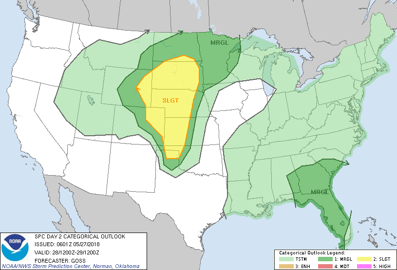
Greeley, CO...Rapid City, SD...Grand Island, NE...Kearney, NE...Garden City, KS...
MARGINAL
392,613
30,726,245
Jacksonville, FL...Denver, CO...Colorado Springs, CO...Minneapolis, MN...Tampa, FL...
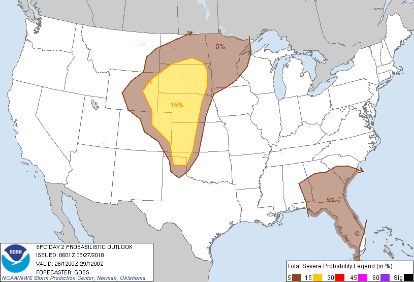
Probabilistic Graphic
Probability of severe weather within 25 miles of a point. Hatched Area: 10% or greater probability of significant severe within 25 miles of a point.
Day 2 Prob. Risk
Area (sq. mi.)
Area Pop.
Some Larger Population Centers in Risk Area
15 %
218,218
1,470,142
Rapid City, SD...Grand Island, NE...Kearney, NE...Garden City, KS...Dodge City, KS...
5 %
392,816
30,802,132
Jacksonville, FL...Denver, CO...Colorado Springs, CO...Minneapolis, MN...Tampa, FL...
   SPC AC 270601

   Day 2 Convective Outlook
   NWS Storm Prediction Center Norman OK
   0101 AM CDT Sun May 27 2018

   Valid 281200Z - 291200Z

   ...THERE IS A SLIGHT RISK OF SEVERE THUNDERSTORMS ACROSS PORTIONS OF
   THE PLAINS/HIGH PLAINS REGION...

   ...SUMMARY...
   Strong/severe storms are expected across portions of the central and
   High Plains, and into a broader area of the Great Plains.  A couple
   of brief tornadoes will also be possible once again, in conjunction
   with Alberto.

   ...Synopsis...
   While Alberto shifts across the northeast Gulf of Mexico and
   eventually shifts inland Monday, within background large-scale upper
   ridging, a western U.S. upper low is progged to devolve into an open
   wave as it ejects slowly east-northeastward toward the northern and
   central Plains.

   At the surface, high pressure will prevail east of the Mississippi
   River away from the circulation surrounding Alberto.  Farther west,
   a lee trough is progged to reside over the High Plains, with a
   menagerie of outflow boundaries from prior convection expected over
   the Dakotas/western Nebraska vicinity through the first half of the
   period.  Afternoon cyclogenesis may occur along the lee trough over
   eastern Colorado, as an upper disturbance rotating around the main
   western low/trough shifts across the central High Plains region.

   ...The north-central U.S. southward across western portions of the
   Plains and into the central High Plains...
   A rather complex convective scenario appears likely to unfold for
   Monday, as Sunday/early Monday convection from the Wyoming vicinity
   into the Dakotas/Nebraska -- along with associated convective
   outflow and cloud debris -- will likely alter/influence favored
   zones for subsequent Monday convective development.

   At this time, it appears that threat will be somewhat lessened with
   northward extent into North Dakota, with greatest heating and
   destabilization suppressed westward to the higher terrain of
   Wyoming, and southward across the High Plains/Plains ahead of the
   lee trough.

   As an upper disturbance rotates northeastward out of the southern
   Rockies toward the central High Plains, a moderately unstable
   airmass should support afternoon storm development, with ascent
   focused near the lee trough and possible weak cyclogenesis occurring
   over the eastern Colorado area, as well as over portions of eastern
   Wyoming -- both in upslope-favored areas and along possible/residual
   outflow.  With enhanced southwesterly flow aloft associated with the
   aforementioned disturbance overspreading the central High
   Plains/Plains atop low-level southeasterlies, shear will favor
   development of organized/supercell storms.  While uncertainty
   regarding evolution of intervening convective events precludes an
   outlook upgrade at this time, expect potential for large hail and
   damaging winds, along with the potential for a couple of tornadoes.
   Storms may grow upscale linearly into one or more lines/bands by
   evening -- shifting northeast out of Wyoming into parts of South
   Dakota, and eastward out of the High Plains across western Kansas
   and the Texas/Oklahoma Panhandles, with risk for hail and damaging
   winds continuing well into the evening.

   ...The Southeast...
   Alberto -- progged to have evolved into a tropical storm -- is
   forecast to make landfall over western portions of the Florida
   Panhandle Monday evening.  Within a large envelope east/northeast of
   the center of circulation, bands of showers and thunderstorms
   occurring within a kinematic field featuring enhanced 0-3 km shear
   will result in occasional cells acquiring low-level rotation.  Thus,
   will maintain a rather large 5%/MRGL risk to cover potential for
   occurrence of brief tornadoes.

   ...MAXIMUM RISK BY HAZARD...
   Tornado:   5%     - Slight
   Wind:     15%     - Slight
   Hail:     15%     - Slight

   ..Goss.. 05/27/2018

   CLICK TO GET WUUS02 PTSDY2 PRODUCT

   NOTE: THE NEXT DAY 2 OUTLOOK IS SCHEDULED BY 1730Z