SPC AC 021729
Day 2 Convective Outlook
NWS Storm Prediction Center Norman OK
1229 PM CDT Sat Jun 02 2018
Valid 031200Z - 041200Z
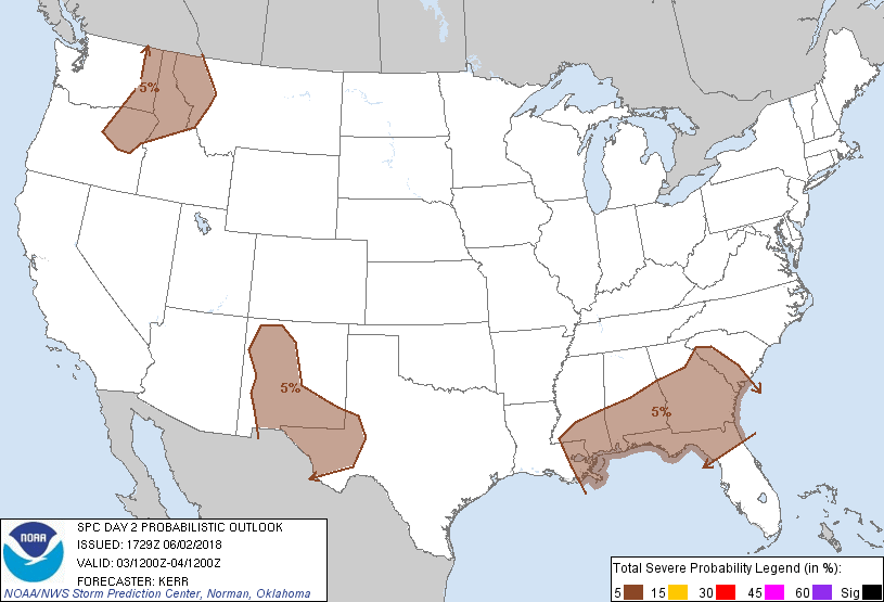
...THERE IS A MARGINAL RISK OF SEVERE THUNDERSTORMS SUNDAY INTO
SUNDAY NIGHT ACROSS PARTS OF THE SOUTHERN ROCKIES...SOUTHEAST AND
NORTHERN INTERMOUNTAIN REGION...
...SUMMARY...
A few strong to severe storms will be possible Sunday into Sunday
night across parts of the southern Rockies and adjacent High Plains,
the Southeast, and the interior Pacific Northwest.
...Synopsis...
The stronger belt of mid-latitude westerlies emanating from the
Pacific may remain more or less zonal through this period, but with
broad troughing beginning to develop inland of the Pacific coast,
while broad downstream ridging continues to shift eastward, across
and east of the Canadian Prairies and northern U.S. Rockies.
Farther east, a significant short wave trough is forecast to
progress across the Great Lakes region, while ridging in the
northern branch of split downstream flow shifts into New England,
and troughing within the southern branch shifts off the middle and
southern Atlantic coast. A subtropical high, elongated along an
axis across southern Baja into the southern U.S. Plains, appears
likely to remain prominent, but a substantive impulse is forecast to
continue migrating around its northwestern/northern periphery,
across the Four Corners vicinity toward the central High Plains.
In lower levels, models suggest that significant surface
cyclogenesis is possible northeast of the upper Great Lakes region,
while much more modest cyclogenesis takes place off the southern Mid
Atlantic coast. Sharp low-level cooling/drying with the former
feature is expected to continue an eastward/southward surge, across
the Appalachians into the Atlantic Seaboard, and through the Gulf
States, while stalling along the western slopes of the southern
Rockies. At least some initial subsidence/drying may be ongoing at
the outset of the period to the lee of the southern Appalachians in
association with the latter feature, while cool/stable boundary
layer air gradually advances southward to the lee of the central
Appalachians.
...Southeast...
Convective potential for Sunday remains unclear. Ahead of the
southeastward advancing front, lower/mid tropospheric flow may be
only modest in strength and largely west/northwesterly, with
low-level convergence remaining generally weak. However, beneath a
remnant plume of elevated mixed layer air suppressed to the south of
the stronger mid-latitude westerlies, low-level moisture is expected
to remain sufficient to contribute to large CAPE (2000-3000+ J/kg)
with daytime heating. Guidance is suggestive that one or more
subtle perturbations within the northwesterly flow aloft (perhaps
convective generated) may suppress inhibition sufficiently to
support scattered afternoon/evening thunderstorm activity,
particularly across parts of southern Alabama and Georgia into
northern Florida. Given the potential instability, some of this may
be accompanied by a marginal severe wind/hail risk.
...New Mexico/Southwest Texas...
Models indicate appreciable destabilization is possible Sunday in
the presence of steep lapse rates, mainly across the higher terrain
to the west of the Rio Grande River in New Mexico, and perhaps into
the Sacramento/Guadalupe/Davis Mountains vicinity of southern New
Mexico into southwest Texas. It appears that this will occur in the
presence of strengthening southwesterly 500 mb flow (30-50
kt--associated with impulse migrating around the subtropical ridge),
which could provide sufficient vertical shear for isolated
supercells with a severe hail/wind threat before diminishing Sunday
evening.
Cooler/drier low-level air initially advecting into the southern
High Plains may be problematic to vigorous convective development
with severe weather potential spreading east of the southern Rockies
Sunday evening.
...Northern intermountain region...
Models indicate that a vigorous short wave impulse progressing
inland of the Pacific coast will probably be accompanied by
sufficient forcing for ascent and strengthening shear to support a
risk for severe storm development, including supercells, given
sufficient destabilization Sunday afternoon and evening. This
remains unclear at this time, but at least weak destabilization
appears possible across the higher terrain of northeast Oregon into
western Montana.
...MAXIMUM RISK BY HAZARD...
Tornado: <2% - None
Wind: 5% - Marginal
Hail: 5% - Marginal
..Kerr.. 06/02/2018
CLICK TO GET WUUS02 PTSDY2 PRODUCT
NOTE: THE NEXT DAY 2 OUTLOOK IS SCHEDULED BY 0600Z