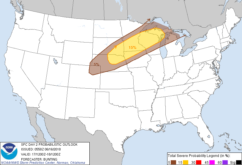
Minneapolis, MN...St. Paul, MN...Sioux Falls, SD...Rochester, MN...Sioux City, IA...
MARGINAL
167,103
3,667,355
Green Bay, WI...Duluth, MN...Appleton, WI...Waterloo, IA...Oshkosh, WI...
Probabilistic Graphic
Probability of severe weather within 25 miles of a point. Hatched Area: 10% or greater probability of significant severe within 25 miles of a point.
Day 2 Prob. Risk
Area (sq. mi.)
Area Pop.
Some Larger Population Centers in Risk Area
15 %
139,482
7,228,635
Minneapolis, MN...St. Paul, MN...Sioux Falls, SD...Rochester, MN...Sioux City, IA...
5 %
163,127
3,468,163
Green Bay, WI...Duluth, MN...Appleton, WI...Oshkosh, WI...Sheboygan, WI...
   SPC AC 160558

   Day 2 Convective Outlook
   NWS Storm Prediction Center Norman OK
   1258 AM CDT Sat Jun 16 2018

   Valid 171200Z - 181200Z

   ...THERE IS A SLIGHT RISK OF SEVERE THUNDERSTORMS FROM PORTIONS OF
   THE CENTRAL/NORTHERN PLAINS INTO THE UPPER MIDWEST AND NORTHERN
   GREAT LAKES...

   ...SUMMARY...
   Severe thunderstorms will be possible Sunday and Sunday Night across
   portions of the central and northern Plains, Upper Midwest and
   northern Great Lakes.

   ...Synopsis...
   A large upper-level anticyclone will remain established over much of
   the eastern U.S. Sunday while an upper-level low over the Great
   Basin moves little.  The remnants of tropical system Bud will lift
   north through the northern Plains.  A surface cold front will move
   slowly southward, extending from western Lake Superior southwest to
   northeast CO and then northwest into southern ID late Sunday
   afternoon.  A dryline will extend from weak low pressure over
   eastern CO southward into far west TX.

   ...Central/northern Plains and upper Midwest into northern Great
   Lakes...
   A very moist air mass (upper 60s/lower 70s dew points) will remain
   in place in the vicinity of the cold front, which will move slowly
   southward late in the day.  Although mid-level lapse rates will not
   generally be as steep as previous days owing to multiple rounds of
   thunderstorms, diurnal heating will still result in moderate/pockets
   of strong surface-based instability in the vicinity of the frontal
   boundary Monday afternoon.  Latest guidance continues to suggest a
   series of weak mid-level disturbances in the southwesterly flow
   between the eastern U.S. ridge and the Great Basin upper low lifting
   northeast along the front, contributing to thunderstorm development
   during the late afternoon and evening.

   Vertical shear ranging between 35 and 50 kts will support supercell
   potential initially with severe hail and wind possible.  Orientation
   of shear vectors largely parallel to the front, combined with little
   remaining CINH during peak heating, should result in cell
   mergers/upscale growth into clusters of storms moving northeast/east
   through the evening.  Damaging winds and large hail will remain
   possible with these clusters.

   Isolated severe storms will be possible within low-level upslope
   flow over northeast CO Sunday afternoon, where weak surface-based
   instability will combine with somewhat stronger flow resulting in
   40-50 kts of deep-layer shear.  Supercells capable of large hail
   will be possible.

   ...MAXIMUM RISK BY HAZARD...
   Tornado:   2%     - Marginal
   Wind:     15%     - Slight
   Hail:     15%     - Slight

   ..Bunting.. 06/16/2018

   CLICK TO GET WUUS02 PTSDY2 PRODUCT

   NOTE: THE NEXT DAY 2 OUTLOOK IS SCHEDULED BY 1730Z