Lincoln, NE...Grand Island, NE...Kearney, NE...Garden City, KS...Fremont, NE...
MARGINAL
349,653
32,329,020
Indianapolis, IN...Columbus, OH...Denver, CO...Kansas City, MO...Omaha, NE...
Probabilistic Graphic
Probability of severe weather within 25 miles of a point. Hatched Area: 10% or greater probability of significant severe within 25 miles of a point.
Day 2 Prob. Risk
Area (sq. mi.)
Area Pop.
Some Larger Population Centers in Risk Area
15 %
79,479
1,075,613
Lincoln, NE...Grand Island, NE...Kearney, NE...Garden City, KS...Fremont, NE...
5 %
348,845
32,098,146
Indianapolis, IN...Columbus, OH...Denver, CO...Kansas City, MO...Omaha, NE...
SPC AC 181703
Day 2 Convective Outlook
NWS Storm Prediction Center Norman OK
1203 PM CDT Mon Jun 18 2018
Valid 191200Z - 201200Z
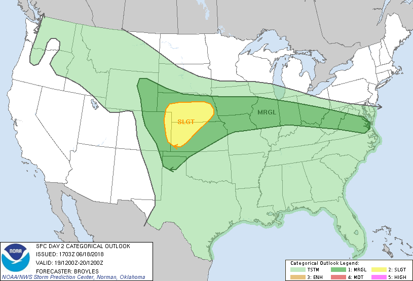
...THERE IS A SLIGHT RISK OF SEVERE THUNDERSTORMS ACROSS PARTS OF
THE CENTRAL PLAINS...
...SUMMARY...
Severe thunderstorms with large hail and wind damage will be
possible across parts of the central Plains Tuesday afternoon and
evening. Marginally severe thunderstorms may also affect parts of
the central High Plains and mid to upper Mississippi Valley
east-southeastward to Virginia.
...Central Plains...
An upper-level low will remain in place across the northern Rockies
and gradually fill on Tuesday as an upper-level trough moves into
the central Rockies. At the surface, a cold front is forecast to
move southward across the central Plains with the moist sector
located from the lower to mid Missouri Valley extending westward
across southern Nebraska. Thunderstorm development is expected to
take place Tuesday afternoon along the front from northwest Kansas
extending northeastward into southeast Nebraska. Convection is also
forecast to initiate in the higher terrain from northeast Colorado
northward into eastern Wyoming with storms developing and moving
eastward into the central High Plains. As storm coverage increases
during the late afternoon and early evening, MCS formation will be
possible across parts of Kansas and Nebraska.
Forecast soundings for 00Z/Wednesday across the slight risk area
from North Platte, NE eastward to Grand Island, NE and southward to
Dodge City, KS generally show impressive thermodynamics coinciding
with supercell wind profiles (0-6 km shear in the 35 to 45 kt
range). This combined with 700-500 mb lapse rates around 8 C/km will
support large hail with any supercell that can develop in the late
afternoon. Conditions for supercells may be greatest in the western
part of the slight risk area due to the closer proximity to the
upper-level trough and stronger deep-layer shear. As convective
coverage continues to increase in the early to mid evening,
multicell may become the more favored mode as a line-segment
organizes and moves east-southeastward across west-central Kansas
and southern Nebraska. Wind damage would become the favored severe
threat if a linear MCS can organize.
...Mid to Upper Mississippi Valley/Ohio Valley/Mid-Atlantic...
A broad region of anticyclonic flow will be in place on Tuesday from
the mid to upper Mississippi and Ohio Valleys extending into the
Mid-Atlantic. At the surface, a cold front is forecast to move
southward across the mid to upper Mississippi Valley, Ohio Valley
and Mid-Atlantic. Thunderstorm development will likely take place
along much of the front Tuesday afternoon as surface temperatures
warm. Due to the presence of the upper-level ridge, deep-layer shear
is forecast to be generally weak across most of the east-central
U.S. This will make multicell and pulse convection the favored storm
modes. Areas that locally heat up the most from near and to the
south of the front, may have the greatest threat for strong
thunderstorm development. Although some hail will be possible near
instability maxima, marginally severe wind gusts would be the most
likely severe threat. The potential for strong wind gusts should be
maximized during or just after peak heating when low-level lapse
rates will be steep.
...MAXIMUM RISK BY HAZARD...
Tornado: 2% - Marginal
Wind: 15% - Slight
Hail: 15% - Slight
..Broyles.. 06/18/2018
CLICK TO GET WUUS02 PTSDY2 PRODUCT
NOTE: THE NEXT DAY 2 OUTLOOK IS SCHEDULED BY 0600Z