SPC AC 090547
Day 2 Convective Outlook
NWS Storm Prediction Center Norman OK
1247 AM CDT Mon Jul 09 2018
Valid 101200Z - 111200Z
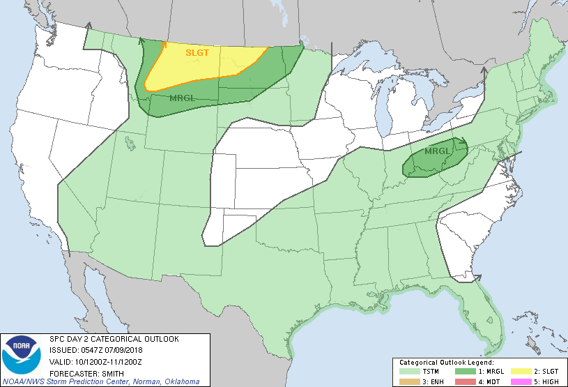
...THERE IS A SLIGHT RISK OF SEVERE THUNDERSTORMS FOR CENTRAL AND
EASTERN MONTANA INTO WESTERN AND NORTHERN NORTH DAKOTA...
...SUMMARY...
Severe thunderstorms are possible over central Montana Tuesday
afternoon and evening and later into northeast Montana and North
Dakota during the evening and overnight hours.
...Synopsis...
A vigorous mid-level shortwave trough is forecast to move from the
Pacific Northwest into northwestern MT by early evening and east
into central Saskatchewan, while evolving into a closed low by early
Wednesday morning. A surface low will develop in lee of the Rocky
Mountain Front over north-central MT and develop eastward into
northeast MT by early evening before the primary low occludes over
central Saskatchewan. A cold front will push eastward through
central and eastern MT late in the day and after dark as a plume of
moisture extends west from ND into MT. Farther east, a cold front
will move southward over the OH Valley and Mid-Atlantic states in
association with a mid-level disturbance over the Lower Great Lakes.
...MT into ND...
Low-level moisture (50s degrees F boundary-layer dewpoints) within
easterly flow beneath a shield of steep 700-500mb lapse rates (8
degrees C/km) will contribute to moderate buoyancy over MT. A belt
of strong mid-level flow will overspread the warm sector as a cap
weakens by mid afternoon. Widely scattered thunderstorms are
forecast to develop over the higher terrain near Yellowstone and
southwest MT. Effective shear magnitudes (40-50 kt) will support
organized storms, including the possibility for supercells, with
large to very large hail and isolated severe gusts possible.
Farther north, stronger deep-layer forcing for ascent will likely
result in scattered thunderstorms developing over southwest
Saskatchewan into perhaps far northern MT. Upscale growth into a
forward-propagating severe squall line is possible within this
corridor over southern Saskatchewan and glancing northeastern
MT/northwest ND within the moisture plume---potentially resulting in
a derecho. Considerable uncertainty remains regarding this
convective-scale dependent scenario, but the possibility for the
southern portion of the squall line moving through northeast MT and
later into northwestern ND (northern half of the Bakken) would
translate to severe gusts (50-75kt). It is possible later outlooks
include higher severe (wind) probabilities.
...OH Valley...
A cold front will push southward during the day into a reservoir of
lower 70s degrees F dewpoints. A mid-level shortwave trough will
move from the northern Great Lakes into the Northeast/central
Appalachians during the Day 2 period. Weak large-scale forcing for
ascent associated with this feature and convergence near the front
will combine with diurnal heating and lead to widely scattered
thunderstorms developing by mid afternoon. Isolated strong to
locally severe gusts (50-60 mph) capable of wind damage are possible
with the more intense thunderstorms. This activity will weaken
during the evening coincident with the loss of heating.
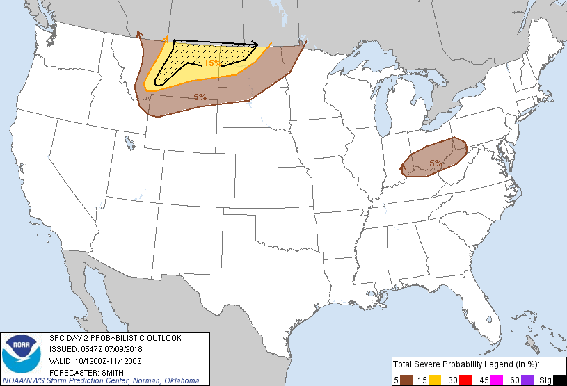
...MAXIMUM RISK BY HAZARD...
Tornado: 2% - Marginal
Wind: 15% SIG - Slight
Hail: 15% SIG - Slight
..Smith.. 07/09/2018
CLICK TO GET WUUS02 PTSDY2 PRODUCT
NOTE: THE NEXT DAY 2 OUTLOOK IS SCHEDULED BY 1730Z