SPC AC 210527
Day 2 Convective Outlook
NWS Storm Prediction Center Norman OK
1227 AM CDT Sat Jul 21 2018
Valid 221200Z - 231200Z
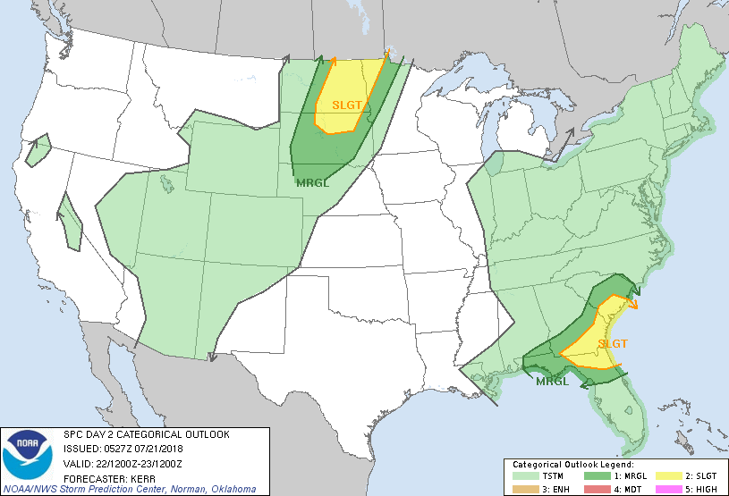
...THERE IS A SLIGHT RISK OF SEVERE THUNDERSTORMS SUNDAY AFTERNOON
AND EVENING ACROSS PARTS OF THE SOUTH ATLANTIC COAST REGION AND
PARTS OF THE NORTHERN PLAINS...
...SUMMARY...
A few severe thunderstorms are possible Sunday afternoon and evening
across parts of the south Atlantic Coast region and across parts of
the northern Plains.
...Synopsis...
To the north of a prominent subtropical high, centered near the
southern Rockies, troughing within the mid-latitude westerlies may
broaden near/north of the western into central Canadian/U.S. border.
Within the troughing, it appears that a substantive short wave
impulse will remain progressive. Associated stronger mid-level
height falls are forecast to spread from Saskatchewan into Manitoba
during the day, before continuing into northwest Ontario and perhaps
developing south of the international border through the eastern
Dakotas and Minnesota by 12Z Monday. Models indicate that the
primary accompanying surface cyclone will remain well to the north
of the international border, but a secondary low may develop across
the mid Missouri Valley, just ahead of a cold front advancing into
the northern U.S. Plains.
Downstream, ridging, building to the northwest of the western
Atlantic subtropical high, is forecast to nose into much of New
England. Between the subtropical highs, models continue to suggest
that large-scale troughing east of the Mississippi Valley may
undergo considerable deformation, elongating southward through much
of the remainder of the south Atlantic Coast region. Seasonably
high moisture content (characterized by precipitable water of 2+
inches) likely will linger in plumes on the southern and eastern
periphery of the troughing. This may include an inland return
across coastal portions of the Mid Atlantic, but lapse rates
supportive of moderate to large CAPE likely will remain focused on
the southern periphery of the troughing, across parts of the eastern
Gulf into south Atlantic coast.
...South Atlantic Coast region...
Convective developments today through tonight could still have a
considerable impact on convective potential for Sunday. However,
the latest model output suggests that moderate to large CAPE will
develop with insolation by midday across much of northern Florida
and southeastern Alabama/Georgia into the coastal plain and piedmont
of South Carolina. This is where forcing for ascent associated with
a short wave impulse digging through the base of the upper trough
may contribute to thunderstorm development. Aided by
momentum/vertical shear associated with 30+ kt flow in 850-500 mb
layer, a few supercell structures or organizing clusters of storms
are possible, posing a risk for hail and potentially damaging wind
gusts.
...Northern Plains...
Although stronger mid-level forcing for ascent likely will remain
north of the international border, seasonably strong westerly
mid/upper flow near the base of the upper troughing may contribute
to sufficient shear for organized convective development, including
supercells, ahead of the front across the Dakotas. This may be
supported by lift associated with weak low-level warm advection and
high-level difluent/divergent flow, with model output now suggesting
sufficient boundary layer moistening to support moderately large
CAPE within at least a narrow pre-frontal corridor.
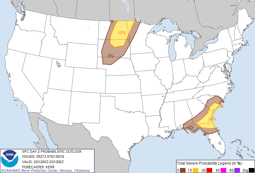
...MAXIMUM RISK BY HAZARD...
Tornado: 2% - Marginal
Wind: 15% - Slight
Hail: 15% - Slight
..Kerr.. 07/21/2018
CLICK TO GET WUUS02 PTSDY2 PRODUCT
NOTE: THE NEXT DAY 2 OUTLOOK IS SCHEDULED BY 1730Z