Colorado Springs, CO...St. Louis, MO...Aurora, CO...Little Rock, AR...Amarillo, TX...
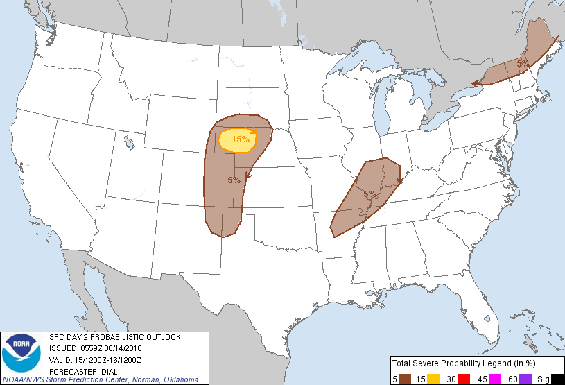
Probabilistic Graphic
Probability of severe weather within 25 miles of a point. Hatched Area: 10% or greater probability of significant severe within 25 miles of a point.
Day 2 Prob. Risk
Area (sq. mi.)
Area Pop.
Some Larger Population Centers in Risk Area
15 %
20,719
77,207
North Platte, NE...Scottsbluff, NE...
5 %
240,172
9,855,966
Colorado Springs, CO...St. Louis, MO...Aurora, CO...Little Rock, AR...Amarillo, TX...
SPC AC 140559
Day 2 Convective Outlook
NWS Storm Prediction Center Norman OK
1259 AM CDT Tue Aug 14 2018
Valid 151200Z - 161200Z
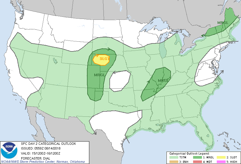
...THERE IS A SLIGHT RISK OF SEVERE THUNDERSTORMS OVER A PORTION OF
WESTERN NEBRASKA...
...SUMMARY...
A few severe storms are possible, mainly over the central High
Plains Wednesday afternoon and evening. Isolated strong to severe
storms will also be possible over the middle Mississippi Valley
region as well as New England.
...Synopsis...
A rather complex upper pattern will persist through Wednesday with
cutoff low now over the Mid Atlantic transitioning to a progressive
open wave and moving offshore early in the period. The upper low now
over western OK will deamplify as it moves through the mid MS
Valley. Farther west, a shortwave trough is forecast to become
cutoff from belt of stronger westerlies and advance through the
northern High Plains. At the surface a cold front will advance
southeast through New England with trailing portion into NE, where
it will likely stall. A weak surface low accompanied by a surface
trough or weak front will accompany the shortwave trough through the
middle MS Valley region.
...Central High Plains...
East to southeasterly low-level winds will reside in vicinity of and
north of front across northern NE into southern SD, maintaining
influx of upper 50s to near 60 F dewpoints beneath modest (7-7.5)
mid-level lapse rates. Showers and storms may be ongoing across SD
within zone of ascent north of front and immediately downstream of
the progressive shortwave trough. However, diabatic heating should
promote destabilization of the surface layer south of front with up
to 1500 J/kg MLCAPE expected. Mid-upper jet within the base of the
trough will contribute to 40-45 kt effective bulk shear across
western NE, and storms are expected to redevelop as the boundary
layer destabilizes during the afternoon. A few supercells capable of
large hail and downburst winds will be the main threats.
Additional storms will probably develop farther south over the
higher terrain of CO and northern NM and spread east into the High
Plains. While vertical shear will be weaker, supporting mostly
multicells, the thermodynamic environment may promote a modest
threat for a isolated large hail and downburst winds through early
evening.
...Middle Mississippi Valley region...
Thunderstorms will likely redevelop within the plume of subtropical
moisture accompanying a deamplifying shortwave trough and
convectively enhanced boundaries. Weak lapse rates, areas of clouds
and ongoing precipitation and weak vertical shear should limit
overall severe threat. However, 30-35 kt flow in the 850-500 mb
layer accompanying the shortwave trough suggests where diabatic
heating occurs, a few storms could pose a threat for locally strong
wind gusts from afternoon into early evening.
...New England...
At least isolated storms are expected to develop along and ahead of
the shortwave trough and attendant cold front by late afternoon or
early evening. Temperatures are not expected to be overly warm but
dewpoints in the low to mid 60s will help foster enough instability
for a few stronger storms capable of mainly isolated strong wind
gusts.
...MAXIMUM RISK BY HAZARD...
Tornado: 2% - Marginal
Wind: 15% - Slight
Hail: 15% - Slight
..Dial.. 08/14/2018
CLICK TO GET WUUS02 PTSDY2 PRODUCT
NOTE: THE NEXT DAY 2 OUTLOOK IS SCHEDULED BY 1730Z