SPC AC 251730
Day 2 Convective Outlook
NWS Storm Prediction Center Norman OK
1230 PM CDT Sat Aug 25 2018
Valid 261200Z - 271200Z
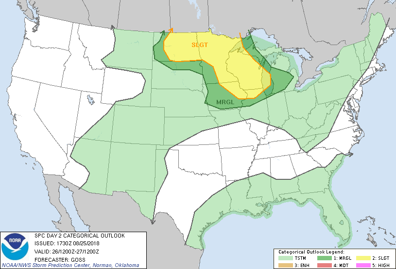
...THERE IS A SLIGHT RISK OF SEVERE THUNDERSTORMS FROM THE NORTHERN
PLAINS INTO THE UPPER MISSISSIPPI VALLEY/UPPER MIDWEST/WESTERN UPPER
GREAT LAKES REGION...
...SUMMARY...
Severe thunderstorms are possible Sunday through Sunday night across
parts of the northern Plains and into the Upper Mississippi
Valley/Upper Midwest/western Upper Great Lakes region.
...Synopsis...
Weak ridging aloft is progged to persist across roughly the southern
half of the U.S. Sunday, with faster/more amplified flow farther
north. Within this faster flow, a trough is forecast to move slowly
east across the Intermountain region with time, while a couple of
smaller-scale lead features cross the central and northern Plains
during the period.
At the surface, the main feature is expected to be a low and
associated cool front which should move east-northeast across the
northern Plains, with a front extending southwestward across the
northern and central Plains by the end of the period.
...Northern Plains across the Upper Mississippi Valley/western Upper
Great Lakes...
Thunderstorms are forecast to be ongoing across portions of the
central Plains/mid Missouri Valley area, and possibly into the upper
Mississippi Valley region early in the period. Storms may
linger/spread east-northeast through the day, and should locally
strengthen during the afternoon across the upper Mississippi
Valley/upper Midwest region as the boundary layer destabilizes.
With moderate southwesterly flow aloft, potential for hail and/or
locally damaging winds may evolve with stronger storms. Some hints
exist that storms may grow upscale into a band/line during the
evening across Wisconsin and possibly northern Illinois, which could
allow wind risk to extend well into the evening.
Meanwhile farther to the northwest, destabilization is forecast
through the day across the northern Plains area, ahead of the
short-wave trough crossing the northern Intermountain Region.
Eventually, storm development is expected near/north of a
weak/developing northern Plains surface low, and an inverted trough
extending north into the Canadian Prairie. With low-level
southerly/southeasterly flow beneath seasonably strong mid-level
southwesterlies, shear supportive of organized/rotating storms
suggests potential for large hail and damaging winds with stronger
storms -- and perhaps even a tornado or two near/north of the
surface low where backed low-level southeasterlies should exist.
With time, there are hints that upscale/linear growth may occur as
storms spread across North Dakota and possibly/eventually into
northern Minnesota. This would permit severe risk to persist
through the evening and into the overnight hours.
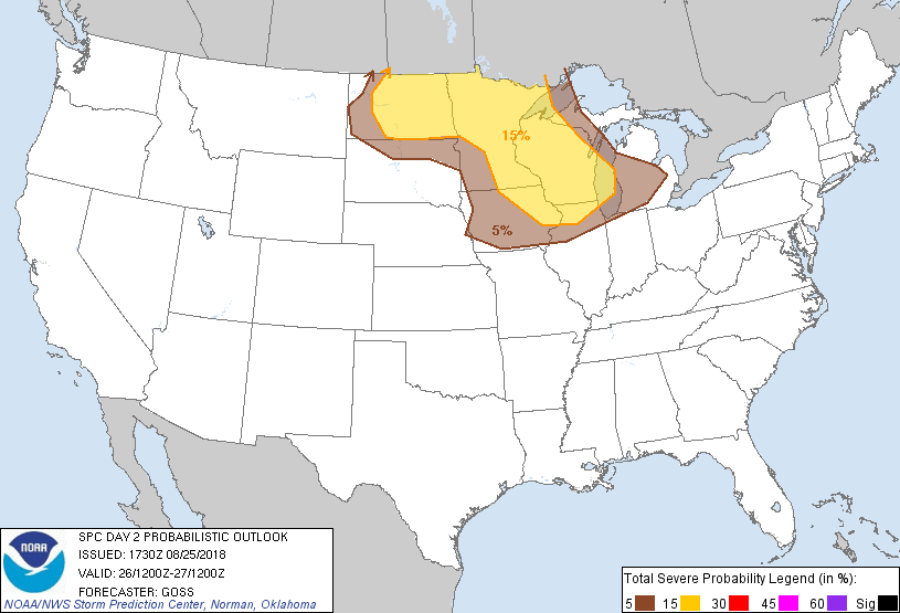
...MAXIMUM RISK BY HAZARD...
Tornado: 5% - Slight
Wind: 15% - Slight
Hail: 15% - Slight
..Goss.. 08/25/2018
CLICK TO GET WUUS02 PTSDY2 PRODUCT
NOTE: THE NEXT DAY 2 OUTLOOK IS SCHEDULED BY 0600Z