Madison, WI...Rockford, IL...Cedar Rapids, IA...Green Bay, WI...Davenport, IA...
SPC AC 300519
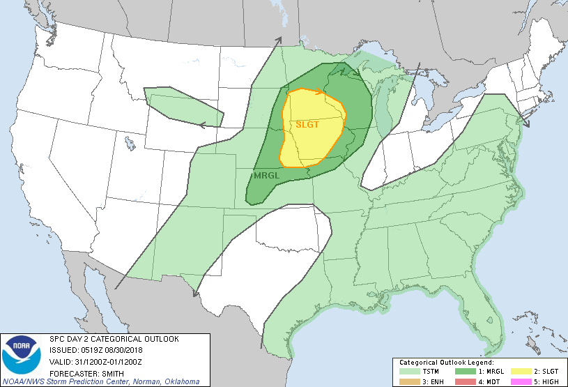
Day 2 Convective Outlook
NWS Storm Prediction Center Norman OK
1219 AM CDT Thu Aug 30 2018
Valid 311200Z - 011200Z
...THERE IS A SLIGHT RISK OF SEVERE THUNDERSTORMS FOR SOUTHERN
MINNESOTA...MUCH OF IOWA...AND INTO EASTERN PARTS OF NEBRASKA AND
SOUTH DAKOTA...
...SUMMARY...
Isolated to scattered severe thunderstorms are possible from
portions of the central Plains northeastward into the Upper Midwest
mainly Friday afternoon into Friday night.
...Central Plains into the Upper Midwest...
A low-amplitude mid-level trough will move across the north-central
U.S. on Friday before moving into western Ontario overnight. A belt
of moderate west-southwesterly mid-level flow will encompass the
area from the north-central High Plains eastward into IA/WI. The
strength of flow will weaken considerably south of a west-east line
paralleling the NE/KS and IA/MO borders as a mid-level anticyclone
is centered from the southern Plains east through the Mid-Atlantic
states. A cold front/surface trough will sag into parts of the
Upper Midwest and extend into the central High Plains where a weak
area of low pressure is forecast.
It seems increasingly likely one or more thunderstorm clusters may
be ongoing Friday morning over the southern half of MN and perhaps
northwest MO and adjacent states in response to a warm advection
regime. A marginal risk for a few strong thunderstorms (marginally
severe hail) or a strong gust could occur before this activity
probably dissipates during the mid/late morning as a the LLJ wanes.
However, models maintain a weakened but identifiable LLJ with a
terminus over IA. Additional storm development is possible on the
leading edge of outflow with a severe risk possibly maintained as
the boundary layer destabilizes and thunderstorms become
surface-based.
Model guidance appears to suggest mid-late afternoon storm
development probably occurring near the MN/northeast SD border
region as a cap erodes near the surface boundary. Forecast
soundings show MLCAPE 1500-2500 J/kg with 40 kt effective shear
which would promote rapid storm organization. Large hail (perhaps
significant) is possible especially early during the convective life
cycle due in part to 8 degree C/km 700-500 mb lapse rates. An
evolution into a linear band will probably occur during the evening
with damaging gusts becoming the dominant hazard.
Farther south, a more conditional severe risk is apparent with
varying model solutions. Nonetheless, a very unstable airmass with
sufficient mid-level shear for supercells warrants maintaining
15-percent severe probabilities over eastern NE. It seems the
chance for thunderstorms increases near the MO River and into
western IA during the early evening perhaps on the residual outflow
intersection with steep low-level lapse rates from the west. A
hail/wind hazard threat would accompany any sustained thunderstorm
activity that manages to develop during the early evening and
perhaps grow upscale during the night.
...MAXIMUM RISK BY HAZARD...
Tornado: 2% - Marginal
Wind: 15% - Slight
Hail: 15% - Slight
..Smith.. 08/30/2018
CLICK TO GET WUUS02 PTSDY2 PRODUCT
NOTE: THE NEXT DAY 2 OUTLOOK IS SCHEDULED BY 1730Z