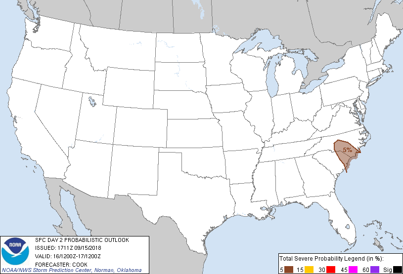
Fayetteville, NC...Wilmington, NC...Florence, SC...Myrtle Beach, SC...Sanford, NC...
Probabilistic Graphic
Probability of severe weather within 25 miles of a point. Hatched Area: 10% or greater probability of significant severe within 25 miles of a point.
Day 2 Prob. Risk
Area (sq. mi.)
Area Pop.
Some Larger Population Centers in Risk Area
5 %
19,303
2,420,525
Fayetteville, NC...Wilmington, NC...Florence, SC...Myrtle Beach, SC...Sanford, NC...
SPC AC 151711
Day 2 Convective Outlook
NWS Storm Prediction Center Norman OK
1211 PM CDT Sat Sep 15 2018
Valid 161200Z - 171200Z
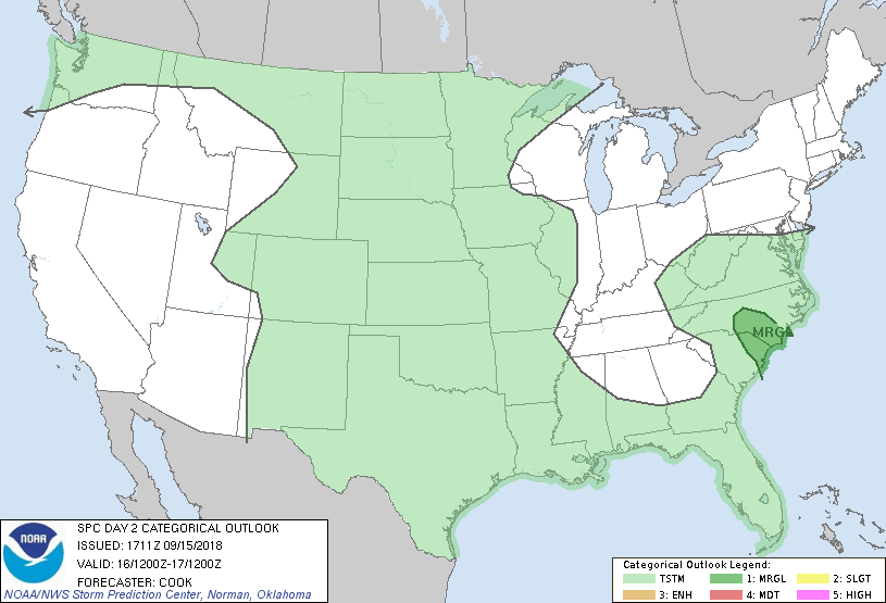
...THERE IS A MARGINAL RISK OF SEVERE THUNDERSTORMS ACROSS PORTIONS
OF THE CAROLINAS...
...SUMMARY...
Severe risk appears minimal across most of the U.S. Sunday, though a
couple of brief tornadoes may occur in conjunction with Florence.
...Synopsis...
A broad anticyclone will dominate the synoptic pattern across the
central and eastern U.S. while troughing persists across the West.
Meanwhile, Florence will continue to migrate slowly northward
along/near the southern Appalachians during the day , with
persistent bands of precipitation occurring to the east and
southeast of the circulation center. A cold front will migrate
southward across the northern Plains late in the period and reach
the South Dakota/Nebraska border area by 12Z Monday - with lee
troughing persisting south of this trough across the High Plains
throughout the forecast period.
...Carolinas and Virginia...
Enhanced low-level southeasterly flow will continue on the eastern
periphery of the circulation of Florence, with bands of convection
originating from a weakly to moderately unstable pre-convective
airmass (buoyed by mid/upper 70s F dewpoints) along coastal areas
and near the Gulf Stream. Models suggest that enough low-level
shear will persist to support updraft rotation and perhaps a brief
tornado or two - especially early in the forecast period before
Florence migrates away from the region. Shear profiles will support
updraft rotation farther north into western Virginia and vicinity,
although any resultant tornado threat will likely be tied to whether
areas of insolation can boost surface-based instability. Marginal
probabilities have been introduced for this outlook where
shear/instability will support some tornado risk.
...Eastern Montana...
Isolated/elevated thunderstorm activity is expected early in the
forecast period downstream of a mid-level trough centered over the
Pacific Northwest. Convective coverage may be highest right at the
beginning of the forecast period, with storms migrating
northeastward into Canada relatively quickly through 15Z or so.
...South Dakota and vicinity...
Weak convergence in the 850-700mb layer will combine with steep
mid-level lapse rates and sufficient deep shear to foster a marginal
hail threat toward 12Z Monday. However, the timing of convective
development is in question - and concentration of the storms may be
1) isolated at best and 2) hold off into the early D3 period. Given
uncertainties, severe probabilities are withheld although any
convection will pose a marginal hail risk.
...MAXIMUM RISK BY HAZARD...
Tornado: 2% - Marginal
Wind: 5% - Marginal
Hail: <5% - None
..Cook.. 09/15/2018
CLICK TO GET WUUS02 PTSDY2 PRODUCT
NOTE: THE NEXT DAY 2 OUTLOOK IS SCHEDULED BY 0600Z