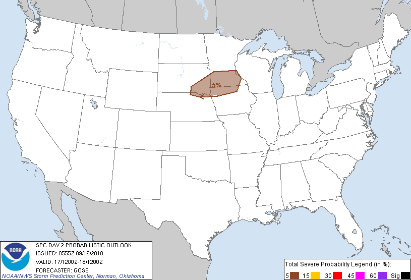
Minneapolis, MN...St. Paul, MN...Sioux Falls, SD...Rochester, MN...Bloomington, MN...
Probabilistic Graphic
Probability of severe weather within 25 miles of a point. Hatched Area: 10% or greater probability of significant severe within 25 miles of a point.
Day 2 Prob. Risk
Area (sq. mi.)
Area Pop.
Some Larger Population Centers in Risk Area
5 %
48,456
4,020,376
Minneapolis, MN...St. Paul, MN...Sioux Falls, SD...Rochester, MN...Bloomington, MN...
SPC AC 160555
Day 2 Convective Outlook
NWS Storm Prediction Center Norman OK
1255 AM CDT Sun Sep 16 2018
Valid 171200Z - 181200Z
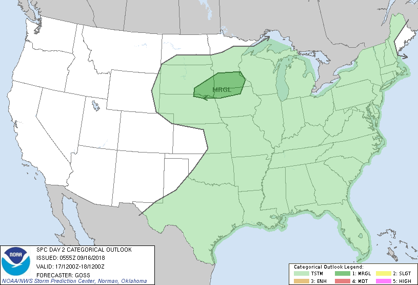
...THERE IS A MARGINAL RISK OF SEVERE THUNDERSTORMS ACROSS PARTS OF
THE UPPER MIDWEST/UPPER MISSISSIPPI VALLEY AREA...
...SUMMARY...
A few severe storms may occur across parts of the upper
Midwest/upper Mississippi Valley area Monday.
...Synopsis...
A rather stagnant upper flow pattern is progged over much of the
U.S. this period, as a trough remains just off the West Coast and
ridging persists over the southwestern and south-central states.
Meanwhile in the east, Florence is progged to move across the upper
Ohio Valley and central Appalachians as a tropical depression, per
the latest NHC track forecasts.
Aside from Florence, the most prominent surface feature will be a
cold front, progged to cross eastern Canada and the Great Lakes
region. Trailing portions of this front will likely become
increasingly oriented west-to-east, lingering in a quasi-stationary
manner across the central Plains and upper Midwest through the
period.
...Southeast South Dakota/southern Minnesota/northern Iowa area...
As the trailing portion of a cold front lingers across the upper
Midwest, showers and scattered thunderstorms are expected across
portions of the area. While a weakly capped boundary layer should
largely hinder surface-based storms, elevated convection --
especially after dark in conjunction with low-level jet development
-- is expected just north of the boundary. With fairly steep lapse
rates aloft expected, and with the southern fringe of stronger
mid-level southwesterlies near and just north of the surface front,
a few stronger/locally severe storms may evolve. Should a
surface-based storm or two develop in the warm sector by late
afternoon, locally damaging winds would be possible. Otherwise,
hail appears to be the primary risk across this area with a few of
the stronger/elevated storms.
...The Upper Ohio Valley and central Appalachians...
Florence will continue a gradual weakening trend with time as it
becomes increasingly absorbed within mid-latitude west-northwesterly
flow. While shear within the lowest couple of km will likely remain
sufficient for low-level rotation, especially early in the period,
widespread precipitation/cloud cover should once again limit
potential for heating/destabilization across the region. Therefore,
with potential for stronger/cellular updrafts expected to remain
low, any tornado potential across the area likewise appears limited,
so as to preclude inclusion of a risk area at this time.
...MAXIMUM RISK BY HAZARD...
Tornado: 2% - Marginal
Wind: <5% - None
Hail: 5% - Marginal
..Goss.. 09/16/2018
CLICK TO GET WUUS02 PTSDY2 PRODUCT
NOTE: THE NEXT DAY 2 OUTLOOK IS SCHEDULED BY 1730Z