St. Louis, MO...Louisville, KY...Lexington-Fayette, KY...Madison, WI...Erie, PA...
SPC AC 240450
Day 2 Convective Outlook
NWS Storm Prediction Center Norman OK
1150 PM CDT Sun Sep 23 2018
Valid 251200Z - 261200Z
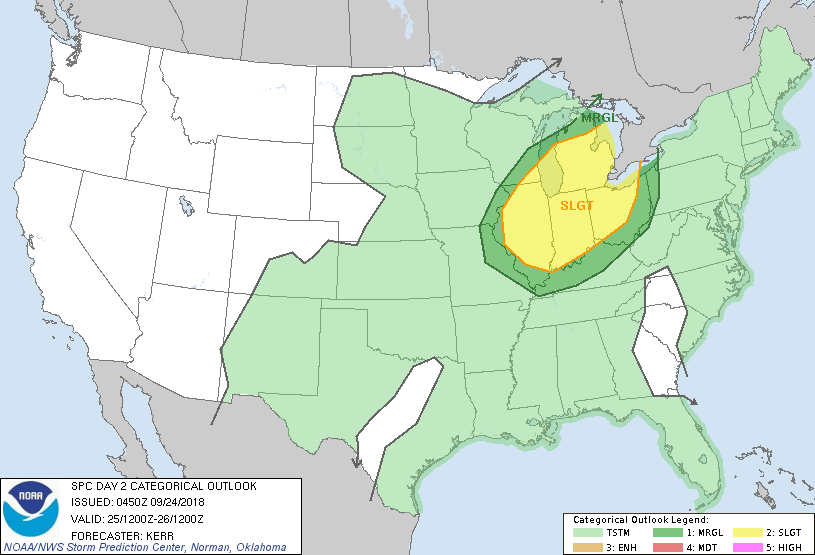
...THERE IS A SLIGHT RISK OF SEVERE THUNDERSTORMS TUESDAY AFTERNOON
INTO TUESDAY NIGHT ACROSS PARTS OF THE MIDDLE MISSISSIPPI AND LOWER
OHIO VALLEYS INTO THE GREAT LAKES REGION...
...SUMMARY...
Severe thunderstorms are possible Tuesday afternoon into Tuesday
night across parts of the middle Mississippi and lower Ohio Valleys
into the Great Lakes region.
...Synopsis...
While subtropical ridging remains fairly prominent across parts of
the western Atlantic through much of the Southeast, models indicate
that large-scale troughing within the mid-latitude westerlies will
continue to generally shift eastward across interior North America
Tuesday/Tuesday night. Guidance is suggestive that there will be a
number of smaller-scale short wave perturbations progressing through
the cyclonic regime, but generally low predictability concerning
these features is evident into and through this period.
Fairly strong surface cyclogenesis associated with one impulse may
proceed well north of the Canadian/U.S border, from southern
Hudson/James Bays through northern Quebec. Guidance suggests that
secondary wave development is possible along the trailing frontal
zone to the south, generally from portions of the upper Midwest
through and northeast of the Great Lakes region by late Tuesday
night. The evolution of this feature will considerably impact the
convective potential for this period, and remains at least somewhat
unclear due to apparent lingering differences among the various
model output.
...Middle Mississippi/lower Ohio Valleys into Great Lakes...
The northward return of upper 60s/lower 70s surface dew points
through the region, ahead of the southeastward advancing front, does
appear fairly certain. However, this may be accompanied by
considerable convection and rain, aided by general large-scale
forcing for ascent, and the extent to which insolation may be able
to contribute to boundary layer destabilization during the day
Tuesday remains unclear.
Despite modest to weak mid-level lapse rates, guidance is suggestive
that breaks in cloud cover could allow for CAPE to increase in
excess of 1000 J/kg by late afternoon. While stronger mid/upper
flow may lag near and to the west of the cold front, 30-50 kt
southwesterly, cyclonic flow around 500 mb probably will still
contribute to sufficient deep layer shear for organized convective
development, including supercells, across the potential warm sector.
The focus for the initiation of storms remains unclear. It is
possible that the leading/northward edge of the richer boundary
layer moisture return may remain ahead of the cold front, oriented
in west/southwest through east/northeast fashion across Illinois,
Indiana and Ohio. But the cold front could still become the most
prominent focus as it advances southeast of the Upper Midwest and
adjacent portions of the Mississippi Valley late Tuesday afternoon
and evening.
Most model output has been suggestive that generally weak low-level
wind fields and hodographs may result in severe wind and perhaps
hail as the primary hazards. However, earlier/more pronounced
surface wave development than generally forecast could be
accompanied by enlarging clockwise curved low-level hodographs
supportive of increasing tornado potential, particularly across
southern portions of the Great Lakes region into portions of the
Ohio Valley.
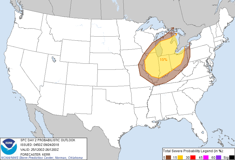
...MAXIMUM RISK BY HAZARD...
Tornado: 5% - Slight
Wind: 15% - Slight
Hail: 15% - Slight
..Kerr.. 09/24/2018
CLICK TO GET WUUS02 PTSDY2 PRODUCT
NOTE: THE NEXT DAY 2 OUTLOOK IS SCHEDULED BY 1730Z