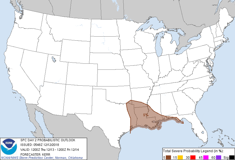
New Orleans, LA...Baton Rouge, LA...Shreveport, LA...Mobile, AL...Jackson, MS...
Probabilistic Graphic
Probability of severe weather within 25 miles of a point. Hatched Area: 10% or greater probability of significant severe within 25 miles of a point.
Day 2 Prob. Risk
Area (sq. mi.)
Area Pop.
Some Larger Population Centers in Risk Area
5 %
115,341
9,298,848
New Orleans, LA...Baton Rouge, LA...Shreveport, LA...Mobile, AL...Jackson, MS...
SPC AC 120548
Day 2 Convective Outlook
NWS Storm Prediction Center Norman OK
1148 PM CST Tue Dec 11 2018
Valid 131200Z - 141200Z
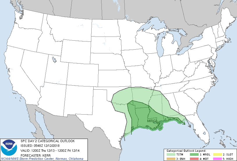
...THERE IS A MARGINAL RISK OF SEVERE THUNDERSTORMS THURSDAY
AFTERNOON INTO THURSDAY NIGHT ACROSS PARTS OF THE ARK-LA-TEX REGION
INTO THE LOWER MISSISSIPPI VALLEY AND NORTH CENTRAL GULF COAST
VICINITY...
...SUMMARY...
Strong thunderstorms may impact parts of the Ark-La-Tex region into
the lower Mississippi Valley and north central Gulf coast vicinity
Thursday into Thursday night, accompanied by at least some risk for
severe weather.
...Synopsis...
Models continue to indicate further amplification within split
westerlies emanating from the mid-latitude Pacific through this
period. Troughing and ridging within these belts across the eastern
Pacific into western North America may become increasingly in phase.
However, the vigorous southern portion of a splitting tough across
and east of the Rockies is forecast to continue digging sharply into
the southern Plains, where a significant embedded lower/mid
tropospheric cyclone may evolve, while it gradually turns eastward
toward the lower Mississippi Valley.
Models generally indicate that this will be accompanied by a
modestly deep and occluding surface low migrating eastward near or
just south of the southern Plains Red River. Secondary surface wave
development still appears possible near/east of the southeast
Louisiana Gulf coast by late Thursday evening.
Large-scale forcing for ascent associated with this evolving regime
is expected to support considerable precipitation and embedded
thunderstorm activity across the southeastern Plains and upper Texas
coastal areas, into the western Gulf of Mexico, through much of the
lower Mississippi Valley and remainder of the Gulf of Mexico. This
probably will include at least some risk for severe thunderstorms.
However, with the Gulf boundary layer only beginning to modify in
the wake of recent cooling/drying, it still appears that severe
weather potential, in general, will be mitigated over inland areas
by weak warm sector boundary layer destabilization.
...Ark-La-Tex/lower Mississippi Valley/Gulf coast...
Broad brush 5 percent severe probabilities have been maintained
across the region with some adjustment based on current expectations
of the evolving warm sector. However, any developing severe weather
potential during this period may ultimately become focused in a
couple of distinct areas.
Cloud cover/precipitation accompanying an initial band or cluster of
convection (largely aided by forcing associated with an initial
perturbation within the subtropical westerlies) probably will
inhibit destabilization through much of the inland developing warm
sector, as it spreads into and east of the lower Mississippi Valley.
However, in the wake of this activity, a developing dry slot may
allow for sufficient insolation to contribute to mixed layer CAPE on
the order of 500 J/kg, beneath cold mid-level air near the Sabine
Valley into the Ark-La-Tex by late Thursday afternoon.
It appears possible that the exit region of a 90-100 kt 500 mb jet
may overspread this instability axis before the onset of diurnal
cooling, supporting discrete storm development across the Ark-La-Tex
vicinity, and perhaps southward through western/central Louisiana.
Given the strong deep layer shear, this may include a couple of
supercells. It remains unclear whether low-level hodographs will
become large enough to support an appreciable risk for tornadoes,
but activity will probably be accompanied by at least some risk for
severe hail and wind before diminishing across the lower Mississippi
Valley Thursday evening.
Otherwise, the secondary surface frontal wave may provide another
focus for isolated severe storm development by Tuesday night, across
coastal areas between southeast Louisiana into the western Florida
Panhandle. In the presence of strengthening deep layer wind fields
and shear, somewhat better boundary layer moistening over the Gulf
of Mexico may contribute to increasing instability across this area.
...MAXIMUM RISK BY HAZARD...
Tornado: 2% - Marginal
Wind: 5% - Marginal
Hail: 5% - Marginal
..Kerr.. 12/12/2018
CLICK TO GET WUUS02 PTSDY2 PRODUCT
NOTE: THE NEXT DAY 2 OUTLOOK IS SCHEDULED BY 1730Z