SPC AC 261734
Day 2 Convective Outlook
NWS Storm Prediction Center Norman OK
1134 AM CST Wed Dec 26 2018
Valid 271200Z - 281200Z
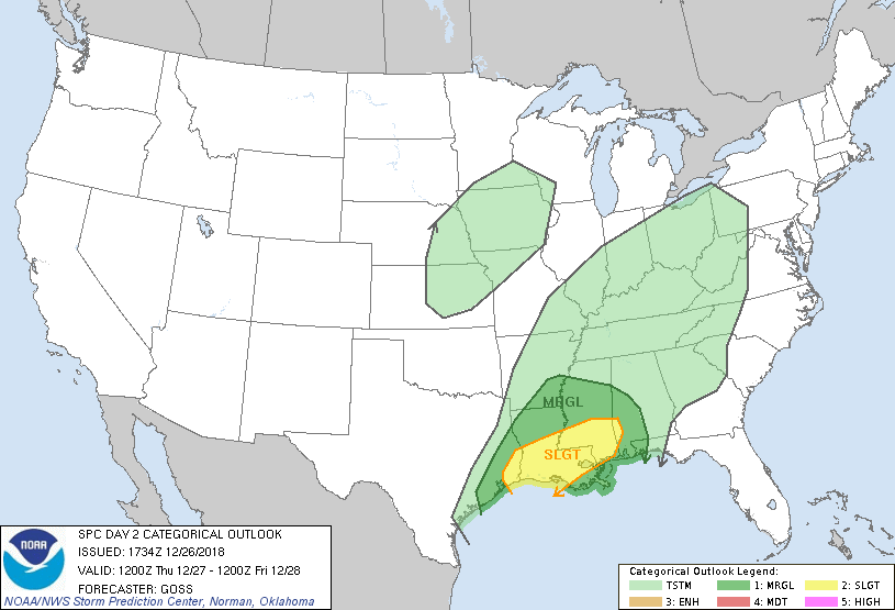
...THERE IS A SLIGHT RISK OF SEVERE THUNDERSTORMS FROM PORTIONS OF
SOUTHEAST TEXAS EAST TO SOUTHWEST ALABAMA...
...SUMMARY...
Scattered severe thunderstorms are possible Thursday from southeast
Texas across central Louisiana and southern Mississippi to parts of
southwest Alabama. Damaging winds and a tornado or two are the
primary severe risks.
...Synopsis...
Slow movement/expansion of cyclonic upper flow is expected over the
U.S. Thursday, with ridging aloft confined to only the West and East
Coasts by the end of the period.
At the surface, a primary low pressure center is progged over the
northeast Kansas vicinity at the start of the period, with a cold
front trailing southward across eastern Oklahoma and into East Texas
and the Texas coastal region. This low is progged to shift
northeastward toward the Great Lakes through the period, in
conjunction with an associated short-wave trough aloft embedded in
the broader cyclonic flow field. As the low advances, the trailing
front will as well -- and is expected to extend from Ohio
south-southwest to near the mouth of the Mississippi by the end of
the period.
...Western and central Gulf Coast region...
Vigorous/locally severe thunderstorms are expected to be ongoing at
the start of the period, from the southern Arkansas/northern
Louisiana vicinity southwest to the upper Texas Coast vicinity.
With south winds ahead of the front advecting high theta-e air
northward/onshore, a zone of ample instability is expected to
precede the front as it advances across the central Gulf Coast
region with time. Though stronger ascent aloft will remain much
farther to the north, ample ascent near the front should maintain a
band/line of storms -- while a few isolated cells may also evolve
ahead of the main frontal band, in a zone of low-level warm
advection.
Again -- with the stronger forcing aloft remaining well to the north
-- and thus likewise the stronger flow field aloft, shear will still
be sufficient to support organized/rotating storms both within the
main band, and with any isolated cells in advance. Therefore,
potential for damaging winds is evident with stronger cells, along
with some threat for hail and a couple of tornadoes. Risk should
persist through the afternoon and into the evening, before waning
some overnight as ascent continues to shift northeast/away from the
region.
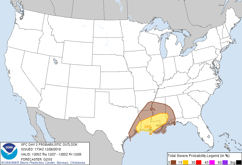
...MAXIMUM RISK BY HAZARD...
Tornado: 5% - Slight
Wind: 15% - Slight
Hail: 15% - Slight
..Goss.. 12/26/2018
CLICK TO GET WUUS02 PTSDY2 PRODUCT
NOTE: THE NEXT DAY 2 OUTLOOK IS SCHEDULED BY 0700Z