Nashville, TN...Kansas City, MO...St. Louis, MO...Cincinnati, OH...Louisville, KY...
SPC AC 290742
Day 3 Convective Outlook
NWS Storm Prediction Center Norman OK
0242 AM CDT Tue May 29 2018
Valid 311200Z - 011200Z
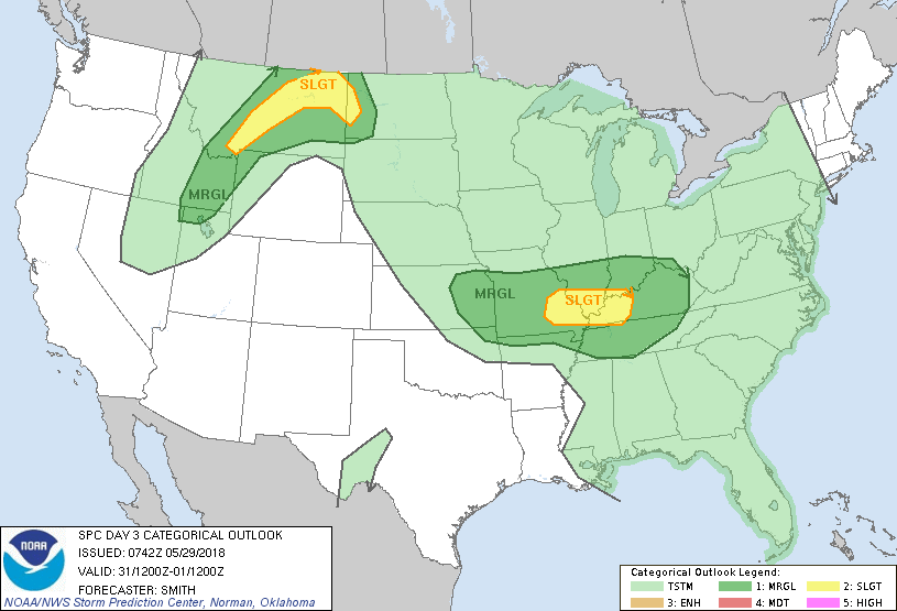
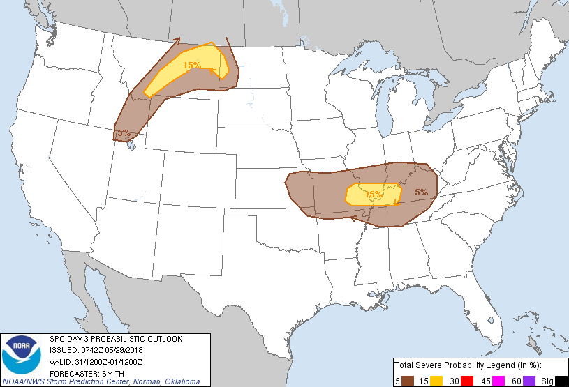
...THERE IS A SLIGHT RISK OF SEVERE THUNDERSTORMS IN PARTS OF THE
MIDDLE MS/LOWER OH VALLEYS AND IN PORTIONS OF EASTERN AND CENTRAL
MT...
...SUMMARY...
Isolated to widely scattered severe thunderstorms are possible
Thursday in the Missouri Ozarks into the lower Ohio Valley and in
the northern High Plains.
...Synopsis...
A mid-level trough over the West Coast States will shift eastward
into the northern Intermountain West. A cold front will push
eastward through portions of ID/MT while a warm frontal zone becomes
better defined across the Dakotas. Models suggest a mid-level
impulse over the central Plains --perhaps convectively augmented--
will move east on the northern periphery of a mid-level anticyclone
centered over northern Mexico.
...Eastern KS east into the lower OH/TN Valleys...
This forecast will likely depend on mesoscale details and inherent
uncertainties associated with smaller-scale features. Nonetheless,
models suggest a weak impulse/belt of moderate westerly mid-level
flow will move from eastern KS into the lower OH Valley by early
evening Thursday. Some thunderstorm activity may be ongoing
Thursday morning over the Ozark Plateau in association with this
weak feature. One of several possible scenarios is for this
early-day activity to weaken and additional thunderstorm development
to occur farther east towards the MS River by early afternoon. A
moist boundary layer will undergo strong heating and yield moderate
buoyancy. Deep-layer shear will largely depend on the strength of
the mid-level perturbation and a nonlinear feedback in terms of
convective-scale thunderstorm organization potential. With those
concerns stated, it appears scattered thunderstorms will develop and
isolated hail and strong to severe gusts resulting in wind damage
may accompany the stronger storms before weakening by early evening.
...MT and western ND into eastern ID...
Models indicate the eastward progression of mid-level trough into
this area during the Day 3 period. As large-scale ascent increases
during the day, isolated to scattered thunderstorms will likely
develop by late afternoon. Forecast soundings show deep-layer shear
supportive of thunderstorm organization. A low-level moisture axis
is depicted from the western Dakotas into northeast MT. It is here
where buoyancy is likely to be greatest. Severe gusts/hail are
forecast to be the primary risks with the stronger storms.
..Smith.. 05/29/2018
CLICK TO GET WUUS03 PTSDY3 PRODUCT
NOTE: THE NEXT DAY 3 OUTLOOK IS SCHEDULED BY 0730Z