SPC AC 250718
Day 3 Convective Outlook
NWS Storm Prediction Center Norman OK
0218 AM CDT Wed Jul 25 2018
Valid 271200Z - 281200Z
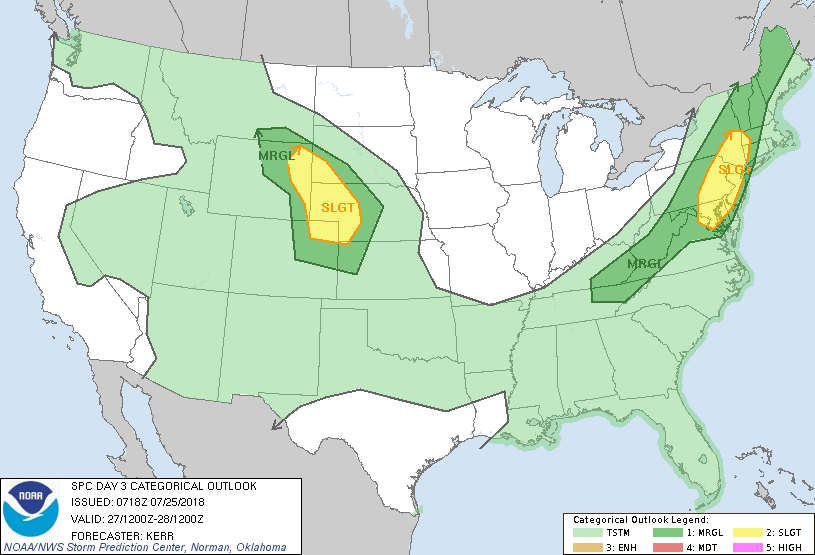
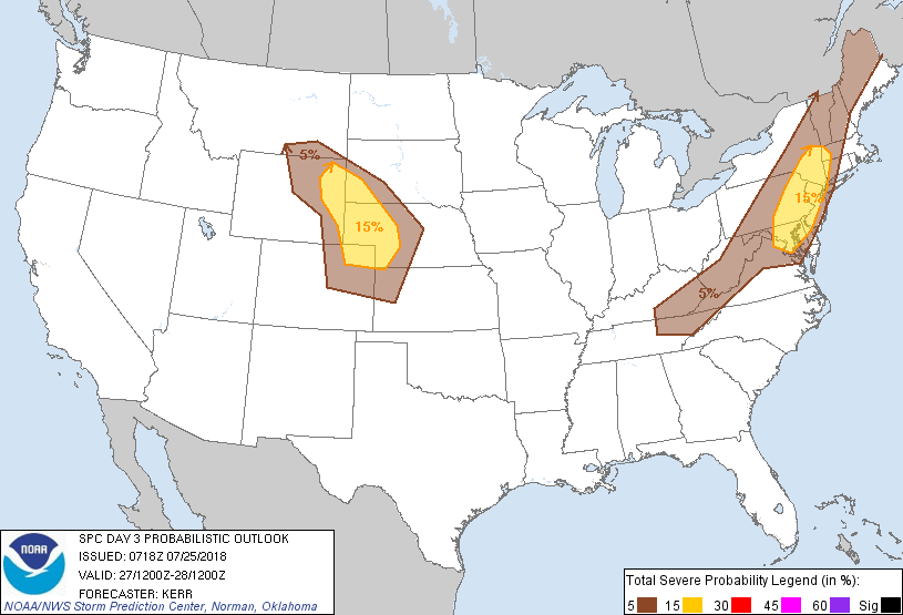
...THERE IS A SLIGHT RISK OF SEVERE THUNDERSTORMS FRIDAY AFTERNOON
AND EVENING ACROSS THE NORTHERN MID ATLANTIC COAST REGION INTO THE
HUDSON VALLEY...AND ACROSS NORTHERN PORTIONS OF THE CENTRAL HIGH
PLAINS...
...SUMMARY...
Severe thunderstorms are possible Friday afternoon and evening
across the Northeast urban corridor from Washington D.C. to New York
City, and surrounding areas of the northern Mid Atlantic and Hudson
Valley. Severe thunderstorms are also possible across northern
portions of the central high Plains.
...Synopsis...
Models indicate little change to the large-scale mid/upper flow from
Thursday into Friday. Subtropical ridging will remain prominent
across the southwestern U.S. and across the western Atlantic, with
broad troughing in between the highs across the Upper Midwest and
middle Mississippi Valley through the middle and northern Atlantic
Seaboard. Within the cyclonic regime, a significant short wave
trough appears likely to gradually pivot across and east of the
lower Great Lakes/upper Ohio Valley, while an embedded lower/mid
tropospheric cyclone turns northeastward across western Quebec, to
the east of James Bay. A trailing surface cold front is expected to
advance southeast of the lower Great Lakes region and lower Ohio
Valley, through much of the Northeast and central/southern
Appalachians.
Beneath seasonably moderate to strong northwesterly mid/upper flow
near the confluence of the mid-latitude westerlies and the
northeastern periphery of the Southwest subtropical ridge, a zone of
stronger differential surface heating is expected by Friday
afternoon across northern portions of the central High Plains. This
should coincide with a plume of elevated mixed-layer air advecting
east of the Wyoming/Colorado Rockies, ahead of another
evolving/digging short wave trough within the mid-latitude
westerlies.
...Central Appalachians into New England...
Forcing for ascent ahead of the short wave trough, and seasonably
strong shear beneath 40+ kt southwesterly 500 mb flow, will
contribute to at least some organized severe weather potential
along/just ahead of the southeastward advancing front. Primary
uncertainty concerns the extent of boundary layer destabilization,
which may only be weak to modest in strength along much of the
front.
Within pre-frontal surface troughing across the northern Mid
Atlantic region into the Hudson Valley, it appears that
lingering/returning seasonably high moisture content (including
surface dew points near 70f) probably will be sufficient to support
moderately large CAPE in conjunction with mid-level cooling. Higher
severe probabilities indicated across this region, including the
urban corridor from Washington D.C. to New York City, reflect of
this. Although low-level hodographs are not forecast to be
particularly large, the environment may become conducive to isolated
supercells by late afternoon. Into Friday evening, with the
approach of the front, considerable upscale convective growth is
possible accompanied by an increasing risk for potentially damaging
wind gusts.
...Northern portions of central high Plains...
Southeasterly near surface flow is expected to remain moist enough
to support moderately large CAPE of 1000-2000 J/kg, with insolation
beneath steep mid-level lapse rates. Although the potential
convective evolution remains unclear, given the presence of strong
deep layer shear beneath 30-40 kt northwesterly mid-level flow, the
environment probably will be conducive to a few supercells, at least
initially. Low-level convergence near a weak low within lee surface
troughing may help focus activity, which could grow upscale into an
evolving mesoscale convective system across western Nebraska Friday
evening, aided by nocturnal strengthening southerly low-level jet
(30-40 kt at 850 mb).
..Kerr.. 07/25/2018
CLICK TO GET WUUS03 PTSDY3 PRODUCT
NOTE: THE NEXT DAY 3 OUTLOOK IS SCHEDULED BY 0730Z