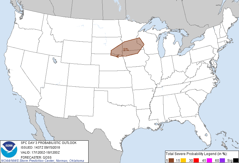
Minneapolis, MN...St. Paul, MN...Sioux Falls, SD...Rochester, MN...Bloomington, MN...
Probabilistic Graphic
Probability of severe weather within 25 miles of a point. Hatched Area: 10% or greater probability of significant severe within 25 miles of a point.
Day 3 Prob. Risk
Area (sq. mi.)
Area Pop.
Some Larger Population Centers in Risk Area
5 %
56,776
5,047,023
Minneapolis, MN...St. Paul, MN...Sioux Falls, SD...Rochester, MN...Bloomington, MN...
SPC AC 151437
Day 3 Convective Outlook CORR 1
NWS Storm Prediction Center Norman OK
0937 AM CDT Sat Sep 15 2018
Valid 171200Z - 181200Z
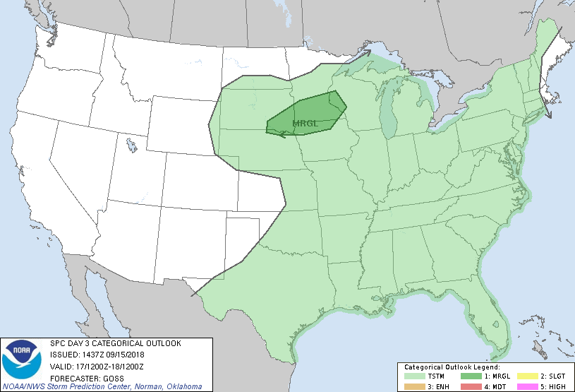
...THERE IS A MARGINAL RISK OF SEVERE THUNDERSTORMS ACROSS PORTIONS
OF THE UPPER MIDWEST/UPPER MISSISSIPPI VALLEY...
CORRECTED FOR PROBABILITY GRAPHIC
...SUMMARY...
A few severe storms may occur across parts of the upper
Midwest/upper Mississippi Valley area.
...Synopsis...
Southward suppression of the upper ridge over the U.S. is forecast
Monday, as a belt of stronger westerly flow shifts gradually
southward. While short-wave troughing should continue to eject
east-northeast across southern Canada, the main trough should remain
just off the West Coast.
As short-wave troughing crosses southern Canada, a surface front
will continue to advance slowly southeastward across the Great Lakes
and northern/central Plains. Meanwhile, remnants of Florence are
expected to be turning more eastward -- shifting across the upper
Ohio Valley and central Appalachians through the period.
...Southeast South Dakota to western Wisconsin...
The slow advance of a frontal zone across the north-central U.S. may
focus an area of thunderstorm development by late afternoon/evening,
despite a somewhat benign upper pattern. Much of the convection is
progged to occur north of the front within a zone of isentropic
ascent, with the warm sector likely to remain capped across much of
the area. However, some potential for a few surface-based storms
appears to exist, from far northeast Nebraska and southeast South
Dakota eastward to western Wisconsin. Here, a combination of
moderate destabilization above the cap and the southern fringe of
stronger mid-level westerlies expanding atop the surface frontal
zone suggest conditional risk for severe weather, should storms
develop. Given this potential, a low-probability/MRGL risk area is
being added to the forecast at this time.
..Goss.. 09/15/2018
CLICK TO GET WUUS03 PTSDY3 PRODUCT
NOTE: THE NEXT DAY 3 OUTLOOK IS SCHEDULED BY 0730Z