SPC AC 030733
Day 3 Convective Outlook
NWS Storm Prediction Center Norman OK
0233 AM CDT Sat Nov 03 2018
Valid 051200Z - 061200Z
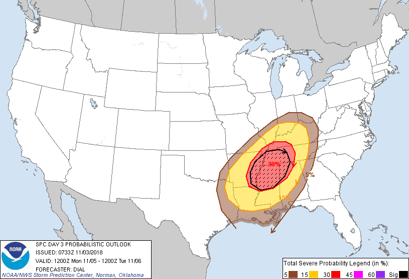
...THERE IS AN ENHANCED RISK OF SEVERE THUNDERSTORMS FROM A PORTION
OF THE LOWER MISSISSIPPI VALLEY INTO THE TENNESSEE VALLEY...
...SUMMARY...
Numerous severe storms with potential for damaging wind and
tornadoes are expected Monday evening into the overnight from a
portion of the lower Mississippi Valley into the Tennessee and Ohio
Valleys.
Primary change to previous outlook for Monday has been to expand the
severe risk areas farther north and east based on latest trends in
model guidance.
Potential still exists for significant severe weather to transpire
Monday evening and overnight, mainly from the lower MS Valley into
the Tennessee Valley regions. Though the NAM and GFS are slightly
less amplified with approaching upper trough compared to the ECMWF,
models have demonstrated reasonably good consistency. Cyclogenesis
should commence by Monday evening over the lower MS Valley in
response to ascent within exit region of an approaching, intense jet
streak within base of an amplifying shortwave trough. The low is
forecast to deepen as it lifts northeast into the OH Valley
overnight with trailing cold front advancing through the TN and
lower MS valley regions. Richer low-level moisture residing over the
northern Gulf will advect rapidly northward through the warm sector
in response to the strengthening low-level jet, contributing to
destabilization with modest instability (1000-1500 J/kg MLCAPE).
Mixed storm modes including a squall line and supercells are likely
to develop along and ahead of advancing cold front Monday afternoon
initially over the lower MS Valley, and continuing east into the TN
Valley and Southeast States Monday night. Impressive wind profiles
with large hodographs and an intense upper jet will promote a threat
for mainly damaging wind and tornadoes, though some hail will also
be possible.
..Dial.. 11/03/2018
CLICK TO GET WUUS03 PTSDY3 PRODUCT
NOTE: THE NEXT DAY 3 OUTLOOK IS SCHEDULED BY 0830Z