SPC AC 250757
Day 3 Convective Outlook
NWS Storm Prediction Center Norman OK
0157 AM CST Tue Dec 25 2018
Valid 271200Z - 281200Z
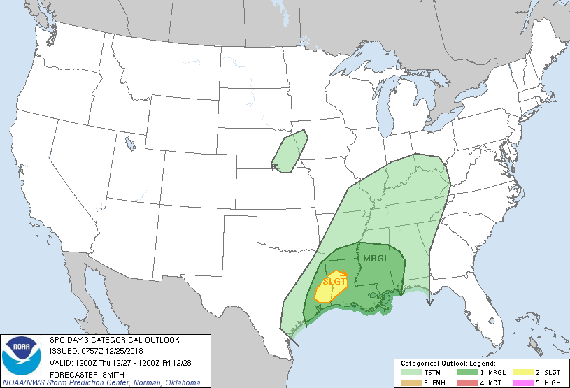
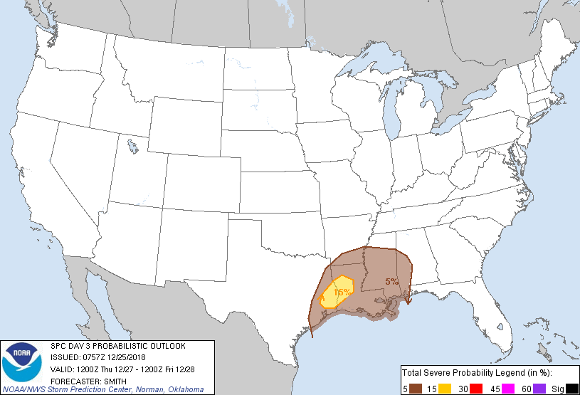
...THERE IS A SLIGHT RISK OF SEVERE THUNDERSTORMS FOR SOUTHEAST
TEXAS INTO CENTRAL LOUISIANA...
...SUMMARY...
Scattered severe thunderstorms are possible Thursday over southeast
Texas into central Louisiana. Damaging winds and a tornado or two
are the primary severe risks.
...Synopsis...
A mid-level low/shortwave trough over the central Great Plains will
weaken as it moves into the Upper Midwest. A broad belt of strong
southwesterly 500mb flow (60-80kt) will extend from the western Gulf
Coast northward into the lower OH Valley. A low-amplitude
disturbance, initially located the base of the larger-scale trough,
will move from southwest TX/Chihuahua into the lower MS Valley late
Thursday night. In the low levels, a surface low will occlude as it
moves into the Upper Midwest with a trailing cold front draping
south through the Ozarks and into the northwest Gulf Coast.
...Southeast TX east into western AL...
An extensive ongoing thunderstorm band over eastern/southeast TX is
expected to move into LA during the late morning. A very strong
southerly low-level jet will facilitate moisture return into LA and
result in middle 60s dewpoints probably reaching into the southern
half of LA. Despite relatively weak lapse rates, MLCAPE ranging
from 250-1000 J/kg and decreasing northward, is forecast within a
strong low- and deep-shear environment. Isolated damaging gusts are
possible but will likely focus near any rear inflow jets with the
mature squall line. Although the environment would conditionally
support supercells ahead of the expected squall line, it is more
probable only a QLCS with damaging gusts is manifested. By the
afternoon, the deep-layer cyclone will become increasingly displaced
from the lower MS Valley. A continued risk for isolated severe may
spread into MS and western AL, but confidence on the magnitude and
coverage of severe is less certain.
..Smith.. 12/25/2018
CLICK TO GET WUUS03 PTSDY3 PRODUCT
NOTE: THE NEXT DAY 3 OUTLOOK IS SCHEDULED BY 0830Z