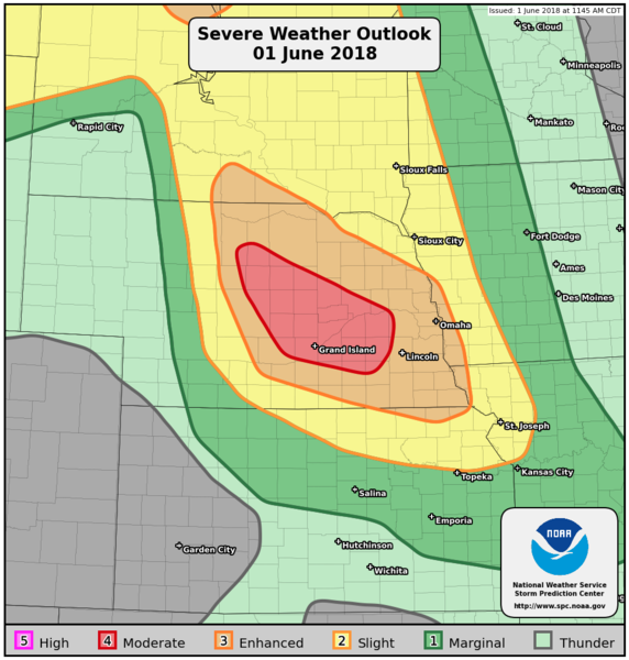
|
| Public Severe Weather Outlook (PWO) |
|
Print Version
|
Note: During early morning hours (approximately 6am Central time), the SPC will produce a multimedia briefing MP4 file shortly after the PWO issuance. Please check back momentarily for a link to this MP4 file on this page. Please note the briefing may be out of date 5 hours after its issuance and there will be no subsequent updates during the day. Please send comments or questions to spc.feedback@noaa.gov or via the feedback page.
View What is a Watch? clip.
|

|
   ZCZC SPCPWOSPC ALL
   WOUS40 KWNS 011708
   NEZ000-020200-

   PUBLIC SEVERE WEATHER OUTLOOK
   NWS STORM PREDICTION CENTER NORMAN OK
   1208 PM CDT FRI JUN 01 2018

   ...Severe thunderstorms expected over parts of the central Plains
   this afternoon and tonight...

   * LOCATIONS...
     Central and eastern Nebraska

   * HAZARDS...
     Widespread damaging winds, some hurricane force
     A few tornadoes
     Widespread large hail, some baseball size

   * SUMMARY...
     Large hail, damaging winds, and a few tornadoes are likely from
     the northern and central Plains into the middle Missouri Valley
     this afternoon into tonight. Severe winds and some hail are also
     expected across parts of the Southeast, with isolated strong to
     severe storms across the southern High Plains.

   Preparedness actions...

   Review your severe weather safety procedures for the possibility
   of dangerous weather today. Stay tuned to NOAA Weather Radio,
   weather.gov, or other media for watches and warnings. A watch
   means that conditions are favorable for severe thunderstorms
   over the next several hours. If a severe thunderstorm warning is
   issued for your area, move to a place of safety, ideally in an
   interior room on the lowest floor of a sturdy building.

   &&

   ..Guyer.. 06/01/2018

   $$
|
|
Top of Page/All Outlooks/Home
|
| Retrieving Previous PWOs |
|---|
|
|
|


