New Orleans, LA...Atlanta, GA...Tampa, FL...St. Petersburg, FL...Baton Rouge, LA...
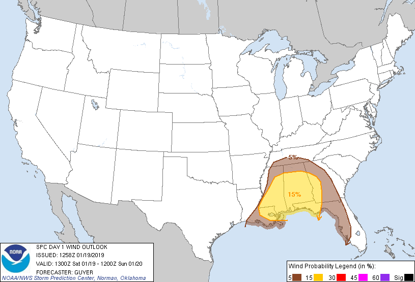
Probabilistic Damaging Wind Graphic
Probability of damaging thunderstorm winds or wind gusts of 50 knots or higher within 25 miles of a point. Hatched Area: 10% of greater probability of wind gusts 65 knots or greater within 25 miles of a point.
Day 1 Wind Risk
Area (sq. mi.)
Area Pop.
Some Larger Population Centers in Risk Area
15 %
110,837
10,425,649
New Orleans, LA...Birmingham, AL...Baton Rouge, LA...Montgomery, AL...Mobile, AL...
Probability of hail 1" or larger within 25 miles of a point. Hatched Area: 10% or greater probability of hail 2" or larger within 25 miles of a point.
Day 1 Hail Risk
Area (sq. mi.)
Area Pop.
Some Larger Population Centers in Risk Area
No Risk Areas Forecast
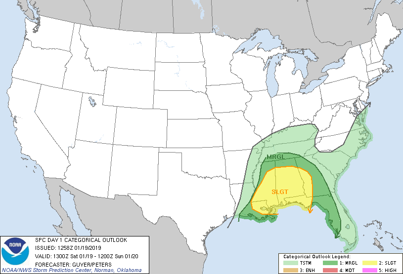
   SPC AC 191258

   Day 1 Convective Outlook
   NWS Storm Prediction Center Norman OK
   0658 AM CST Sat Jan 19 2019

   Valid 191300Z - 201200Z

   ...THERE IS A SLIGHT RISK OF SEVERE THUNDERSTORMS ACROSS PORTIONS OF
   THE GULF COAST/SOUTHEAST STATES...

   ...SUMMARY...
   Scattered to numerous thunderstorms, some of which could be severe,
   are expected across parts of the Gulf Coast states today and
   tonight. Damaging wind gusts and isolated tornadoes are the main
   threats.

   ...Gulf Coast/Southeast States...
   A positive-tilt upper-level trough centered over east TX and
   ArkLaTex vicinity early today will continue to dig/amplify as it
   generally moves east/southeastward, all while a strong cyclonically
   curved polar jet overspreads the middle Gulf Coast States and
   Tennessee Valley.

   A nearly continuous convective line has evolved overnight near an
   advancing cold front and has generally overtaken previously existing
   pre-frontal convection that had included some semi-discrete
   supercells. At daybreak, the most organized/sustained portion of the
   convective line generally extends from east-central MS to southwest
   MS/south-central LA. Lower 60 F surface dewpoints are common ahead
   of the convective line, with some middle 60s F dewpoints across
   southern LA. These dewpoints have been adequate for at least
   near-surface-rooted convection, although the overall modest nature
   of the moisture and thermodynamic environment in general have been
   limiting factors aside from convective mode, at least in regards to
   the overall tornado risk.

   Some diurnal intensification of the linearly organized line of
   storms is plausible this morning into afternoon while low 60s F
   surface dewpoints continue to quickly advect north-northeastward
   across the southern halves of MS/AL and western FL panhandle into
   southwest GA. Upwards of 40-60 kt of effective bulk shear will
   easily support organization within the line. Isolated damaging winds
   will likely be the main threat, but enlarged low-level hodographs
   will support some embedded mesovortices capable of a few tornadoes.
   A slow decrease in intensity should occur from late evening into the
   overnight as this convection eventually outpaces the modest
   low-level moisture return while moving across central/eastern GA and
   the FL Peninsula.

   ...Eastern NC...
   As the upper trough approaches the East Coast, the surface warm
   sector will make some attempt to advance northward across coastal
   portions of NC/SC early Sunday morning as the low-level jet
   strengthens over this region. However, the potential for
   surface-based thunderstorms over land appears too
   uncertain/conditional to include any severe probabilities at this
   time.

   ..Guyer/Peters.. 01/19/2019

   CLICK TO GET WUUS01 PTSDY1 PRODUCT

   NOTE: THE NEXT DAY 1 OUTLOOK IS SCHEDULED BY 1630Z