San Antonio, TX...Austin, TX...Shreveport, LA...Little Rock, AR...Waco, TX...
MARGINAL
296,264
30,142,026
Houston, TX...Dallas, TX...Memphis, TN...Fort Worth, TX...Oklahoma City, OK...
Probabilistic Tornado Graphic
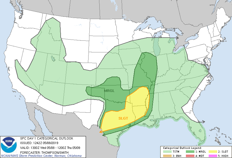
Probability of a tornado within 25 miles of a point. Hatched Area: 10% or greater probability of EF2 - EF5 tornadoes within 25 miles of a point.
Day 1 Tornado Risk
Area (sq. mi.)
Area Pop.
Some Larger Population Centers in Risk Area
5 %
103,122
8,662,987
San Antonio, TX...Austin, TX...Shreveport, LA...Waco, TX...Killeen, TX...
2 %
123,604
11,537,683
Houston, TX...Memphis, TN...Little Rock, AR...Pasadena, TX...Peoria, IL...
Probabilistic Damaging Wind Graphic
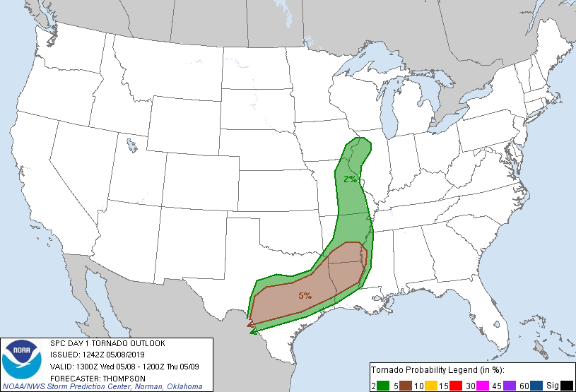
Probability of damaging thunderstorm winds or wind gusts of 50 knots or higher within 25 miles of a point. Hatched Area: 10% of greater probability of wind gusts 65 knots or greater within 25 miles of a point.
Day 1 Wind Risk
Area (sq. mi.)
Area Pop.
Some Larger Population Centers in Risk Area
15 %
165,693
13,214,833
San Antonio, TX...Austin, TX...Shreveport, LA...Little Rock, AR...Waco, TX...
5 %
295,307
30,213,048
Houston, TX...Dallas, TX...Memphis, TN...Fort Worth, TX...Oklahoma City, OK...
Probabilistic Large Hail Graphic
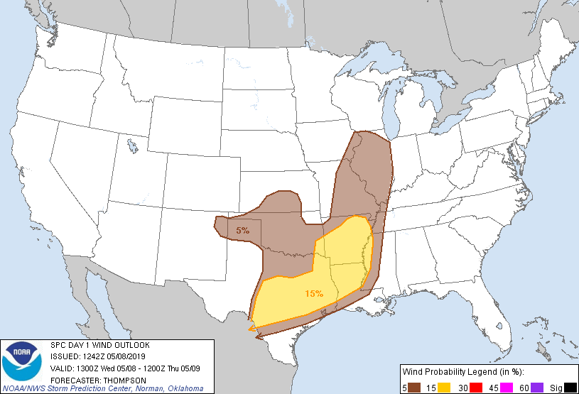
Probability of hail 1" or larger within 25 miles of a point. Hatched Area: 10% or greater probability of hail 2" or larger within 25 miles of a point.
Day 1 Hail Risk
Area (sq. mi.)
Area Pop.
Some Larger Population Centers in Risk Area
15 %
165,236
13,204,241
San Antonio, TX...Austin, TX...Shreveport, LA...Little Rock, AR...Waco, TX...
5 %
297,071
30,503,877
Houston, TX...Dallas, TX...Memphis, TN...Fort Worth, TX...Oklahoma City, OK...
   SPC AC 081242

   Day 1 Convective Outlook
   NWS Storm Prediction Center Norman OK
   0742 AM CDT Wed May 08 2019

   Valid 081300Z - 091200Z

   ...THERE IS A SLIGHT RISK OF SEVERE THUNDERSTORMS TODAY THROUGH
   EARLY TONIGHT FROM CENTRAL TX TO AR AND NORTHERN LA...

   ...SUMMARY...
   Large hail, damaging winds, and a couple of tornadoes will be
   possible today into early tonight from central Texas to Arkansas and
   northern Louisiana.

   ...TX/AR/LA through early tonight...
   A larger-scale trough will persist from the northern Plains to the
   southern Rockies, as a primary shortwave trough ejects northeastward
   from the southern High Plains this morning to KS this afternoon and
   IA by early tonight.  Preceding the primary shortwave trough, an MCV
   over eastern KS will likewise move northeastward toward northern
   IL/southern WI by early tonight.  Outflow with overnight/ongoing
   convection across OK has partially masked the synoptic front which
   appears to be farther north in KS.  Developing convection from the
   Edwards Plateau to northwest TX will likely grow upscale in the zone
   of ascent downstream from the ejecting southern High Plains trough.
   Gradual mergers of the TX/OK storms should lead to a more extensive
   convective band that will subsequently spread eastward toward the
   Arklatex, prior to weakening this evening close to the MS River.

   The storms will be maintained today by an influx of rich low-level
   moisture from the western Gulf of Mexico, near the east edge of an
   elevated mixed layer plume.  Vertical shear will be sufficient for
   organized bowing segments and/or embedded supercells, with an
   attendant threat for damaging winds, large hail, and a couple of
   tornadoes.

   ...Western/central OK and vicinity this afternoon/evening...
   In the wake of the morning convection, residual low-level moisture
   (dewpoints in the 55-62 F range) and surface heating in cloud breaks
   this afternoon will contribute to some destabilization across
   western OK and vicinity.  Most of the numerical model guidance still
   appears to be too moist near the surface, given the extensive
   convective overturning and cold pool generation overnight and into
   this morning across OK.  Thus, buoyancy will likely be weaker, which
   will tend to limit the severe threat, despite deep-layer vertical
   shear favorable for supercells.

   ...MO/IL area today...
   The eastern KS MCV will eject northeastward, with an attendant
   modest enhancement to the low-midlevel flow on its eastern flank.
   However, low-level moisture and buoyancy will remain somewhat
   marginal, and residual cloud cover may also slow surface heating
   some.  These factors suggest that only low wind/hail probabilities
   are warranted.

   ..Thompson/Smith.. 05/08/2019

   CLICK TO GET WUUS01 PTSDY1 PRODUCT

   NOTE: THE NEXT DAY 1 OUTLOOK IS SCHEDULED BY 1630Z