Abilene, TX...Killeen, TX...Wichita Falls, TX...College Station, TX...Bryan, TX...
2 %
338,578
31,302,968
Houston, TX...San Antonio, TX...Austin, TX...Memphis, TN...Oklahoma City, OK...
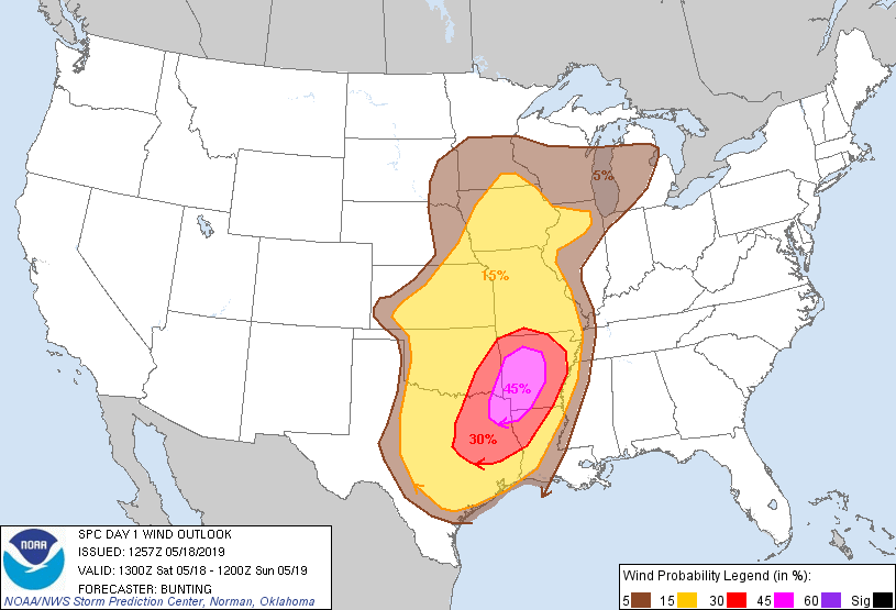
Probabilistic Damaging Wind Graphic
Probability of damaging thunderstorm winds or wind gusts of 50 knots or higher within 25 miles of a point. Hatched Area: 10% of greater probability of wind gusts 65 knots or greater within 25 miles of a point.
Day 1 Wind Risk
Area (sq. mi.)
Area Pop.
Some Larger Population Centers in Risk Area
45 %
31,654
1,927,462
Shreveport, LA...Little Rock, AR...Longview, TX...Bossier City, LA...North Little Rock, AR...
SPC AC 181257
Day 1 Convective Outlook
NWS Storm Prediction Center Norman OK
0757 AM CDT Sat May 18 2019
Valid 181300Z - 191200Z
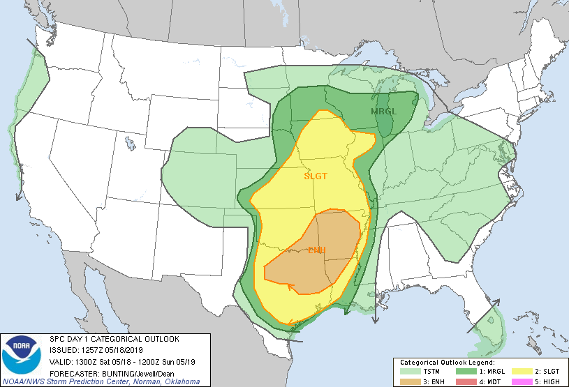
...THERE IS AN ENHANCED RISK OF SEVERE THUNDERSTORMS MUCH OF NORTH
TEXAS...ARKANSAS...SOUTHERN AND EASTERN OKLAHOMA...AND NORTHWEST
LOUISIANA...
...SUMMARY...
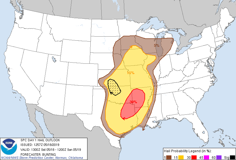
Severe storms are expected from Texas to southern Minnesota, with
the greatest threat from north Texas across southeast Oklahoma into
Arkansas and northwest Louisiana. A few tornadoes, some strong,
widespread damaging winds and large hail are expected.
...Synopsis...
An upper-level trough will move east into the Plains states today
while becoming increasingly negatively tilted with time. A 70-80 kt
mid-level speed max will rotate east/northeast across the OK/North
TX region into southwest MO, while strengthening 850-mb winds
increase to 40-50 kts towards 00Z Sunday. Surface low pressure over
southeast SD will weaken as a new low develops over northwest
OK/southern KS and lifts northeast into IA overnight. A cold front
trailing southwest from the surface low will move east across the
central/southern Plains today, and a warm front extending east from
the low through the OH Valley will lift northward.
...Southern Plains/Arklatex into southern Ozarks...
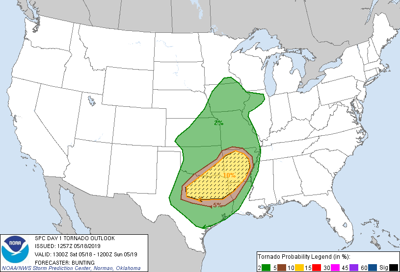
Primary change with this outlook is to expand tornado probabilities,
including significant tornado probability, west across north TX in
advance of on-going supercells with a history of strong low-level
rotation and tornadoes.
Strong/severe thunderstorms are in progress across portions of
northwest/west TX at 13Z, including a mix of semi-discrete
supercells and an evolving linear structure. Current expectations
are for these storms to continue east/northeast through the
afternoon across north TX, central/eastern OK, and western AR in
tandem with large-scale forcing for ascent with the upper trough.
Steep mid-level lapse rates, sampled on regional 12Z soundings,
combined with a very moist atmosphere will result in moderate/strong
surface-based instability. The presence of 45-55 kts of westerly
deep-layer shear and increasing low-level shear will result in an
environment supportive of damaging winds and a few tornadoes via
mesocyclone and QLCS processes. Large hail will also be possible
with any persistent updrafts.
...South-central and Southwest Kansas/Northwest and North-central
Oklahoma...
High-resolution guidance continues to develop storms near the cold
front and strengthening surface low over northwest OK/south-central
KS this afternoon/evening in an environment supportive of very large
hail and damaging winds given ample deep shear and moderate
surface-based instability. Tornado potential will depend on impacts
of ongoing storms over central/southern OK, and this will be
re-evaluated in subsequent outlooks.
...Lower to Mid Missouri Valley/Mid to Upper Mississippi Valley...
The air mass is expected to recover in the wake of overnight
convection sufficiently to support destabilization during the day.
As the cold front advances eastward thunderstorms are expected to
increase in coverage as height falls/large-scale forcing overspreads
the area. Pockets of moderate instability and southwesterly shear of
45-55 kts will support a risk of large hail and damaging gusts with
the strongest storms.
..Bunting/Jewell/Dean.. 05/18/2019
CLICK TO GET WUUS01 PTSDY1 PRODUCT
NOTE: THE NEXT DAY 1 OUTLOOK IS SCHEDULED BY 1630Z