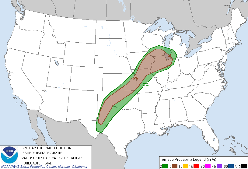
Probability of a tornado within 25 miles of a point. Hatched Area: 10% or greater probability of EF2 - EF5 tornadoes within 25 miles of a point.
Day 1 Tornado Risk
Area (sq. mi.)
Area Pop.
Some Larger Population Centers in Risk Area
5 %
161,126
20,974,505
Chicago, IL...Milwaukee, WI...Kansas City, MO...Wichita, KS...Madison, WI...
2 %
114,437
8,484,414
Oklahoma City, OK...Tulsa, OK...Grand Rapids, MI...Des Moines, IA...Amarillo, TX...
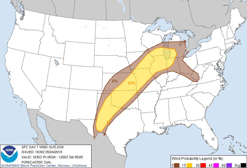
Probabilistic Damaging Wind Graphic
Probability of damaging thunderstorm winds or wind gusts of 50 knots or higher within 25 miles of a point. Hatched Area: 10% of greater probability of wind gusts 65 knots or greater within 25 miles of a point.
Day 1 Wind Risk
Area (sq. mi.)
Area Pop.
Some Larger Population Centers in Risk Area
15 %
261,317
28,485,782
Chicago, IL...Milwaukee, WI...Oklahoma City, OK...Kansas City, MO...Tulsa, OK...
SPC AC 241639
Day 1 Convective Outlook
NWS Storm Prediction Center Norman OK
1139 AM CDT Fri May 24 2019
Valid 241630Z - 251200Z
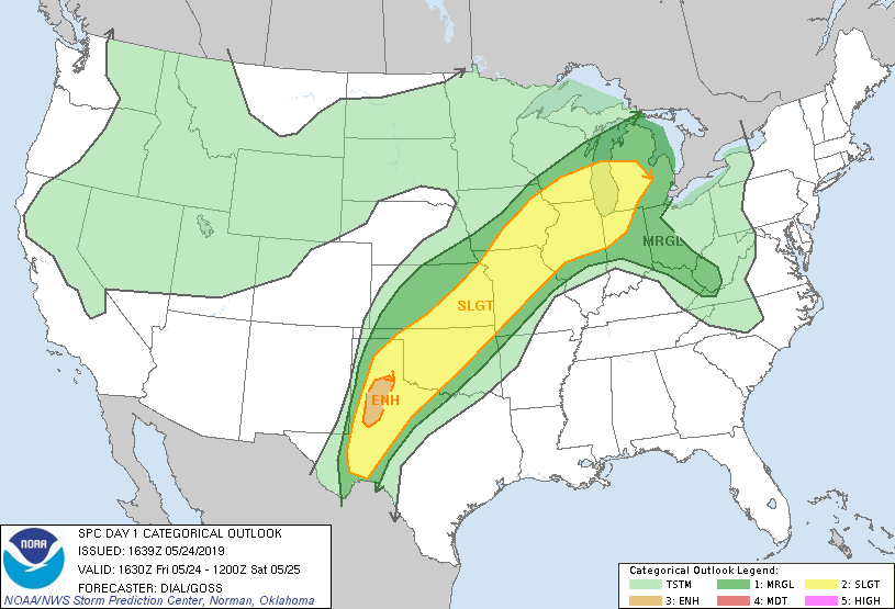
...THERE IS AN ENHANCED RISK OF SEVERE THUNDERSTORMS OVER A PORTION
OF WEST TEXAS...
...SUMMARY...
Severe thunderstorms remain possible this afternoon and tonight from
western portions of Texas through the Upper Midwest and Great Lakes
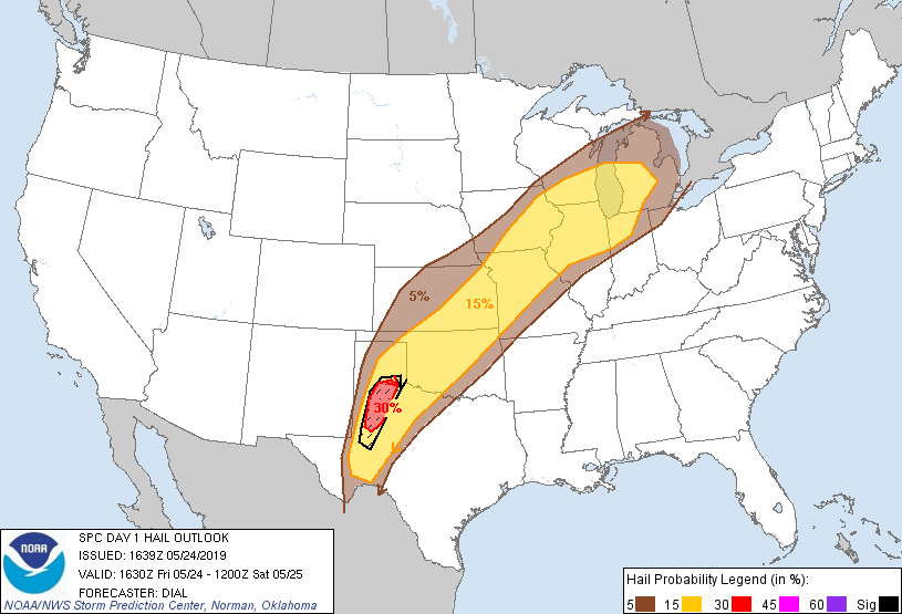
region. Damaging wind and large hail will be the main threats, but a
few tornadoes will also be possible.
...Upper Midwest through Great Lakes region...
Late this morning a warm front extends from southern IA through
central IL and indiana. A weakening outflow boundary continues to
advance southeast into western IL where it intersects the warm
front. MCS that has been ongoing north of this front will continue
east, and a broad southerly low-level jet should promote northward
movement of the warm front into the upper Great Lakes region later
today. Surface dewpoints are in the upper 60s to around 70F south of
the warm front and gradual northward destabilization of the boundary
layer should occur supporting at least moderate instability with
1500-2000 J/kg MLCAPE possible. Complicating factor is effect of
ongoing convection and associated clouds and boundaries which may
slow the northward extent of the destabilization process. Storms are
expected to redevelop along the warm front and residual outflow
boundaries this afternoon. Strongest vertical shear and larger 0-1
km hodographs will exist in vicinity of the warm front. Effective
bulk shear from 40-50 kt will support supercells with large hail,
damaging wind and a few tornadoes possible. Activity may eventually
consolidate into lines or clusters.
...West Texas through Oklahoma and Kansas...
A convective reinforced front extends from the southern TX Panhandle
through northeast KS. A gradual erosion of low clouds and influx of
very moist air with surface dewpoints around 70F will support
Moderate to strong instability this afternoon (2000-3000 J/kg
MLCAPE). Storms are expected to redevelop in vicinity of this
boundary and spread northeast through KS. Other storms are expected
along the dryline. Vertical wind profiles with 40-50 kt effective
bulk shear will support supercells as the initial storm mode. While
0-1 km hodographs will not initially be particularly large, they
will increase by late afternoon into the evening as the low-level
jet strengthens. Large hail and damaging wind will be the main
threats, but a few tornadoes are also possible, especially across
west Texas.
..Dial/Goss.. 05/24/2019
CLICK TO GET WUUS01 PTSDY1 PRODUCT
NOTE: THE NEXT DAY 1 OUTLOOK IS SCHEDULED BY 2000Z