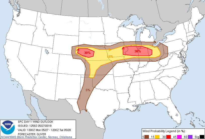
Probability of damaging thunderstorm winds or wind gusts of 50 knots or higher within 25 miles of a point. Hatched Area: 10% of greater probability of wind gusts 65 knots or greater within 25 miles of a point.
Detroit, MI...Milwaukee, WI...Kansas City, MO...Cleveland, OH...Wichita, KS...
SPC AC 271259
Day 1 Convective Outlook
NWS Storm Prediction Center Norman OK
0759 AM CDT Mon May 27 2019
Valid 271300Z - 281200Z
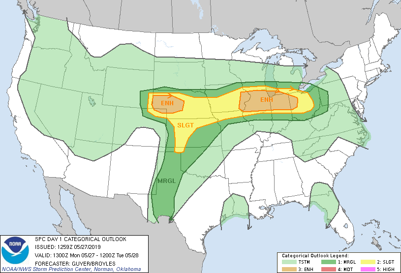
...THERE IS AN ENHANCED RISK OF SEVERE THUNDERSTORMS ACROSS THE
MIDWEST AND THE CENTRAL HIGH PLAINS...
...SUMMARY...
Severe thunderstorms, including a risk for tornadoes, severe hail
and damaging wind gusts, are expected across the Midwest this
afternoon into tonight including eastern Iowa to northern portions
of Illinois/Indiana. Severe storms are also expected across the
central High Plains, and perhaps southward through the Texas South
Plains on a more isolated basis.
...Midwest including eastern Iowa to northern Illinois/Indiana...
Related to a northeast-moving (perhaps convectively augmented)
shortwave trough, a ribbon of flattening/strengthening mid-level
westerlies will overspread the region this afternoon and evening.
These strengthening low/mid-level winds will overlie a
northeast-shifting surface low across northern Iowa to southwest
Wisconsin/northwest Illinois, a west/southwestward extending front
across Iowa, and a northward-shifting front principally across
northern portions of Illinois/Indiana.
That said, some uncertainty exists concerning warm front positioning
later today and peak destabilization/most probable zone of initial
surface-based thunderstorm development owing to persistent bands of
convection (decayed MCS) across Iowa/northern Missouri this morning,
with related factors of lingering cloud cover and some impact on
upstream trajectories owing to the overnight MCS. Regardless, a
trend of steady northward-moistening and destabilization is expected
this afternoon with the warm front, and as clouds erode, upwards of
2500-3000 J/kg MLCAPE is plausible by late afternoon within the warm
sector across eastern/southern Iowa and northern/central Illinois
into central Indiana.
Initial surface-based storm development is expected across eastern
Iowa/northeast Missouri into northwest Illinois this afternoon.
Within a moist/moderately unstable environment, supercells can be
expected amidst ample hodograph length/curvature with upwards of
40-50 kt effective shear. Winds within the lowest 1-2 km AGL will be
diurnally strong and the potential will exist for tornadoes,
particularly near the warm front where low-level/deep-layer shear
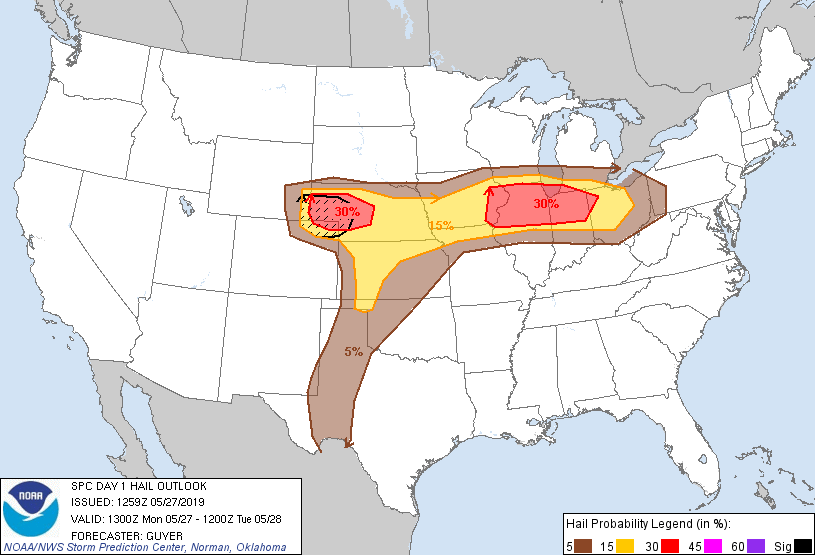
will be maximized. Large hail can also be expected. Severe storms
are likely to develop generally eastward particularly across
northern portions of Illinois/Indiana through the evening.
...Central High Plains/Nebraska/far northern Kansas...
A prominent upper trough will shift east-northeastward over the
southwestern deserts toward the Four Corners area through tonight.
Height falls will occur into the central High Plains in tandem with
a general strengthening/backing of mid-level winds as an upper jet
exit region overspreads the region. In response, surface
cyclogenesis will intensify across eastern Colorado with easterly
low-level upslope flow modestly increasing across northeast
Colorado/southeast Wyoming into western Nebraska.
Initial surface-based thunderstorm development by around
mid-afternoon is anticipated near/just east of the front range of
northern Colorado and southeast Wyoming, with storms subsequently
developing/increasing east-northeastward into the Nebraska Panhandle
through late afternoon/early evening. Although low-level
moisture/buoyancy will not be robust, upwards of 750-1250 J/kg
MLCAPE in the presence of 50+ kt effective shear (accentuated by
very strong southwesterly anvil-level flow) will support supercells
capable of large hail (at least a few 2+ inch diameter hailstones
plausible). Large hail aside, a couple of tornadoes may occur.
Farther to the east/southeast, into southern Nebraska/northern
Kansas, surface-based deep convective development is a little more
uncertain through peak heating, with a more conditional overall
severe/supercell risk late this afternoon/early evening. Of somewhat
greater certainty is the possibility of development toward/after
sunset, including the possibility of gradual upscale growth across
Nebraska this evening in vicinity of the roughly west/east-oriented
surface boundary. In such a scenario, with aid a nocturnally
strengthening low-level jet, a damaging wind/large hail risk could
increase across central/southeast Nebraska and far northern Kansas
during the evening and overnight hours.
...West-central Kansas, OK/TX Panhandles, Texas South Plains...
While confidence is not particularly high across this region, some
concern exists for very isolated but potentially intense storms late
this afternoon/early evening, with some possibility that available
guidance/convection-allowing models are too muted with little or no
suggested deep convective development. At the very least, a
conditional supercell risk will exist.
Some uncertainty exists related to impacts of prior-day convection
and convective overturning across Kansas and western Oklahoma/Texas
Panhandle, but some elevated mixed-layer reestablishment should
occur during the afternoon. Convective inhibition may become very
weak by the 21-23Z time frame in vicinity of the north-south
dryline, with mid-level temperatures not expected to be overly warm
(8C to 10C at 700mb across western Kansas and the Panhandles;
warmest south). While uncertainty exists, if/where sustained deep
convection forms, the environment will likely be conducive to
supercells with a risk for severe hail/wind and possibly tornadoes.
..Guyer/Broyles.. 05/27/2019
CLICK TO GET WUUS01 PTSDY1 PRODUCT
NOTE: THE NEXT DAY 1 OUTLOOK IS SCHEDULED BY 1630Z