The SPC is forecasting ...Severe thunderstorms expected over parts of the central Plains from midday into the overnight....
Please read
the latest public statement about this event. View What is a Watch? clip.
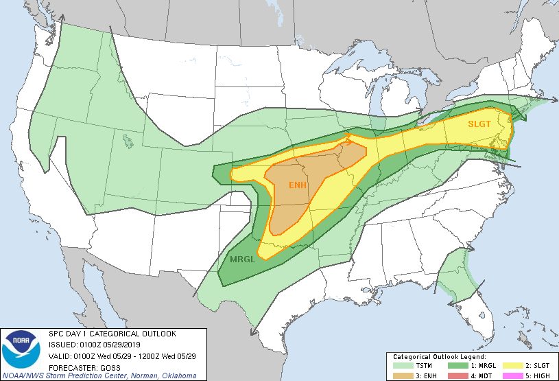
Categorical Graphic
Day 1 Risk
Area (sq. mi.)
Area Pop.
Some Larger Population Centers in Risk Area
ENHANCED
111,112
8,237,417
Oklahoma City, OK...Kansas City, MO...Tulsa, OK...Wichita, KS...Overland Park, KS...
SLIGHT
227,024
50,460,078
New York, NY...Philadelphia, PA...Baltimore, MD...Cleveland, OH...St. Louis, MO...
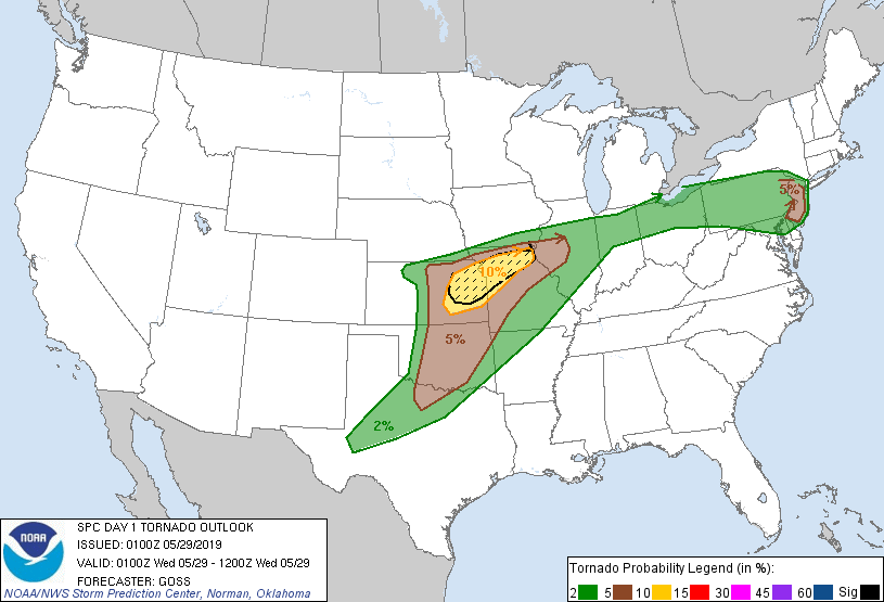
Probability of a tornado within 25 miles of a point. Hatched Area: 10% or greater probability of EF2 - EF5 tornadoes within 25 miles of a point.
Day 1 Tornado Risk
Area (sq. mi.)
Area Pop.
Some Larger Population Centers in Risk Area
SIG SEVERE
25,714
2,829,769
Kansas City, MO...Overland Park, KS...Kansas City, KS...Topeka, KS...Olathe, KS...
10 %
32,367
2,977,683
Kansas City, MO...Overland Park, KS...Kansas City, KS...Topeka, KS...Olathe, KS...
5 %
107,792
14,247,730
Philadelphia, PA...Oklahoma City, OK...Tulsa, OK...Wichita, KS...Elizabeth, NJ...
2 %
232,574
43,965,735
New York, NY...Fort Worth, TX...Baltimore, MD...Cleveland, OH...St. Louis, MO...
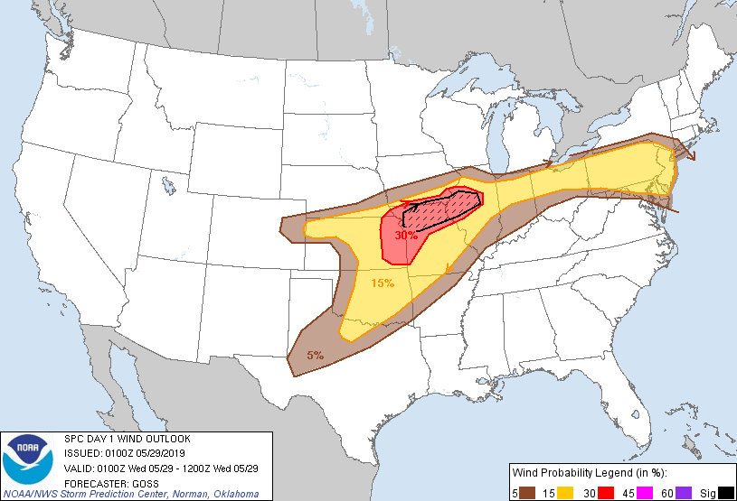
Probabilistic Damaging Wind Graphic
Probability of damaging thunderstorm winds or wind gusts of 50 knots or higher within 25 miles of a point. Hatched Area: 10% of greater probability of wind gusts 65 knots or greater within 25 miles of a point.
   SPC AC 290100

   Day 1 Convective Outlook
   NWS Storm Prediction Center Norman OK
   0800 PM CDT Tue May 28 2019

   Valid 290100Z - 291200Z

   ...THERE IS AN ENHANCED RISK OF SEVERE THUNDERSTORMS ACROSS PORTIONS
   SOUTHEASTERN NEBRASKA/EASTERN KANSAS/CENTRAL AND NORTHERN
   OKLAHOMA...ACROSS NORTHERN AND WESTERN MISSOURI AND SOUTHEASTERN
   IOWA...AND INTO PORTIONS OF ILLINOIS...

   ...SUMMARY...
   Severe storms, capable of producing large hail, damaging wind and a
   couple of tornadoes will continue this evening and into the
   overnight hours from parts of the central and southern Plains
   eastward to the Midwest.  A few severe storms with a threat for
   hail, locally damaging winds and a tornado or two will also persist
   across the Pennsylvania/New Jersey vicinity through this evening.

   ...Southern Nebraska/northern and eastern Kansas eastward into the
   Midwest...
   Storms continue to decrease in coverage across western Kansas, where
   only isolated severe potential persists.  Farther east, more
   robust/substantial severe risk will continue this evening, and into
   the overnight hours.  Several tornadoes have occurred this evening,
   with tornado potential to continue locally over the next few hours
   -- mainly from eastern Kansas to northern Missouri.  Large hail will
   also be possible with stronger cells, and locally damaging winds
   will also be likely, particularly with any convective clusters which
   emerge.  One such bowing cluster is moving across northwest Illinois
   at this time, with attendant risk for damaging winds apparent.

   ...Southern Plains...
   A few strong/severe storms are ongoing across central and into
   northeast Oklahoma, along a north-northeast to south-southwest
   dryline.  The storms extend southwestward into western North Texas
   -- and expansion of scattered storms southwestward into the Texas
   South Plains/Permian Basin/Concho Valley regions may occur later
   this evening/overnight.  While a tornado could occur with one or two
   of the stronger, rotating storms, large hail and locally damaging
   winds will be the primary severe risks.

   ...The Northeast...
   While storm intensity across Ohio and Pennsylvania has begun to
   slowly decrease, with the onset of diurnal stabilization, a few
   vigorous/severe storms persist.  The strongest of these remain over
   parts of northeastern Pennsylvania and into New Jersey, where a
   couple of supercell storms are ongoing.  Along with potential for a
   tornado or two, hail and damaging winds will also be possible
   locally, with these cells.  Elsewhere across the risk area, threat
   primarily for locally damaging winds will persist this evening,
   though overall/gradual convective decrease will continue.

   ..Goss.. 05/29/2019

   CLICK TO GET WUUS01 PTSDY1 PRODUCT

   NOTE: THE NEXT DAY 1 OUTLOOK IS SCHEDULED BY 0600Z