Probability of damaging thunderstorm winds or wind gusts of 50 knots or higher within 25 miles of a point. Hatched Area: 10% of greater probability of wind gusts 65 knots or greater within 25 miles of a point.
Memphis, TN...Shreveport, LA...Little Rock, AR...Waco, TX...Abilene, TX...
5 %
382,072
27,846,819
Indianapolis, IN...Columbus, OH...Oklahoma City, OK...Nashville, TN...Cincinnati, OH...
SPC AC 200117
Day 1 Convective Outlook CORR 1
NWS Storm Prediction Center Norman OK
0817 PM CDT Wed Jun 19 2019
Valid 200100Z - 201200Z
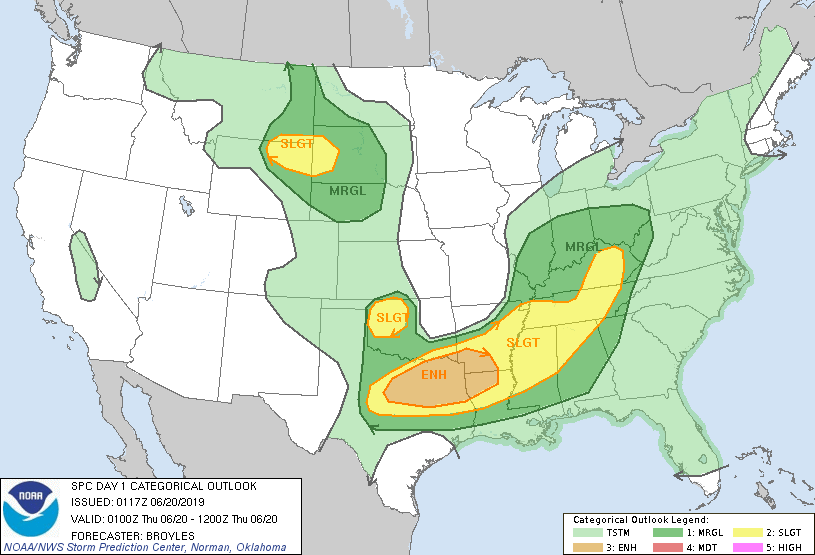
...THERE IS AN ENHANCED RISK OF SEVERE THUNDERSTORMS ACROSS PARTS OF
NORTHERN TEXAS EASTWARD INTO THE ARKLATEX AND THE TENNESSEE/OHIO
VALLEYS...
...THERE IS A SLIGHT RISK OF SEVERE THUNDERSTORMS ACROSS PARTS OF
THE NORTHERN HIGH PLAINS...
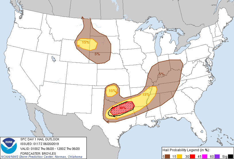
CORRECTED FOR WIND GRAPHIC IN NORTHERN PLAINS
...SUMMARY...
Numerous severe thunderstorms are expected to this evening across
north-central/northeast Texas east into the Arklatex. Very large
hail and severe wind gusts are expected. Other isolated severe
storms are expected from western Tennessee into the Ohio and
Tennessee Valleys.
...Southern Plains/Arklatex...
The latest water-vapor imagery shows a shortwave trough over western
portions of the southern Plains. At the surface, a mesolow is
located in north Texas with a cold front extending southwestward
into west-central Texas. A moist airmass is located ahead of the
front across the eastern half of Texas where surface dewpoints are
in the lower to mid 70s F. This has contributed to the development
of moderate to strong instability early this evening with the RAP
and the Fort Worth sounding showing MLCAPE values across much of
central and eastern Texas in the 3500 to 5000 J/kg range. A cluster
of thunderstorms has developed on the northeastern edge of the
strongest instability across the Arklatex. This MCS may continue to
move eastward across the remainder of southern Arkansas and into
northern Mississippi, western Tennessee and northwestern Alabama
this evening into the overnight period. Moderate deep-layer shear
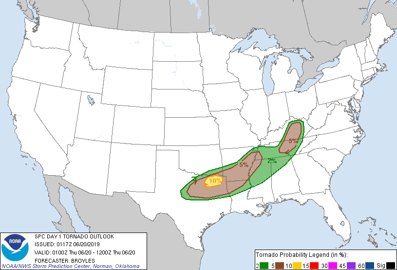
along with enhanced low-level shear due to a low-level speed max in
the Arklatex, will be favorable for supercells and a few tornadoes.
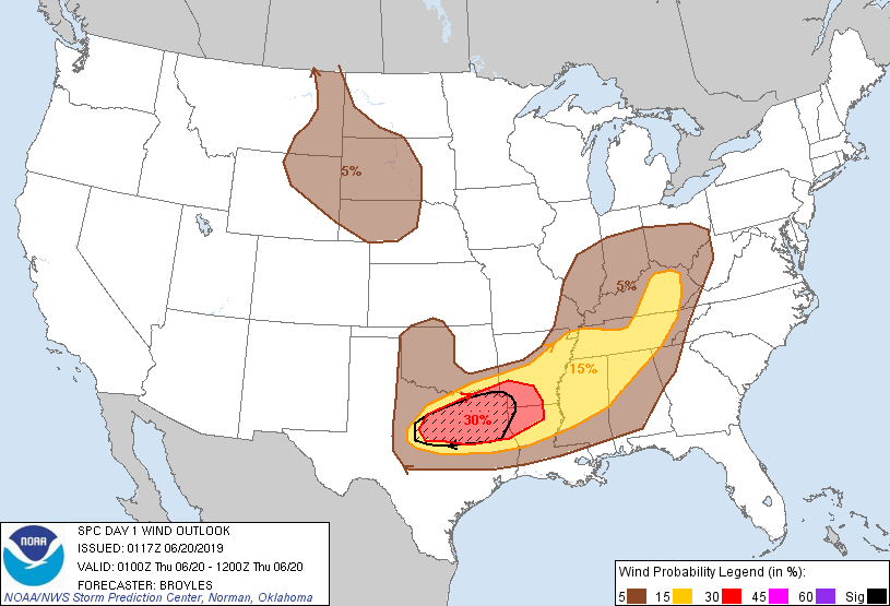
Large hail and wind damage will also be possible with the stronger
rotating storms and bow echoes within the cell cluster. A few storms
could produce very large hail and wind gusts in excess of 70 knots.
The wind-damage threat should persist as the MCS moves eastward into
the northern Gulf Coast states later tonight.
Further west, a cluster of thunderstorms has developed across
north-central Texas, just ahead of the shortwave trough. This
cluster will move eastward into northeast Texas this evening and
should have an isolated tornado threat. Wind damage and isolated
large hail will also be possible. Isolated large hail will also be
possible this evening in northwest Oklahoma where a 15 percent hail
probability contour has been added for ongoing storms.
...Ohio and Tennessee Valleys...
The latest water-vapor imagery shows a shortwave trough over the mid
Mississippi Valley with cyclonic mid-level flow over the Ohio and
Tennessee Valleys. At the surface, a low is present over central
Illinois with a cold front extending southward from the low into the
mid Mississippi Valley. Ahead of the front, a moist airmass is in
place with surface dewpoints mostly in the lower to mid 70s F. This
is contributing to moderate instability with the RAP showing MLCAPE
values in the 1000 to 1500 J/kg range. An MCS is located across
west-central Kentucky extending southward into northern middle
Tennessee. This MCS will continue to move eastward into the southern
Appalachian foothills this evening. Wind damage will be likely along
the leading edge with a couple tornadoes possible within embedded
bow echoes. The threat should become more isolated later this
evening as instability weakens across the region.
...Northern High Plains...
The latest water-vapor imagery shows a shortwave trough over the
northern Rockies with westerly divergent mid-level flow over the
northern Plains. An axis of moderate instability is analyzed by the
RAP from western South Dakota into eastern Montana where MLCAPE
values are estimated to be in the 1000 to 1500 J/kg range. A broken
line of thunderstorms is present on radar from northeast Montana
extending southward into northern Wyoming. Some discrete storms are
located further to the east across northeast Wyoming where the
environment is more favorable for supercells. 0-6 km shear of 50 kt
and steep mid-level lapse rates, evident on forecast soundings,
should be sufficient for isolated large hail and a few damaging wind
gusts this evening.
..Broyles.. 06/20/2019
CLICK TO GET WUUS01 PTSDY1 PRODUCT
NOTE: THE NEXT DAY 1 OUTLOOK IS SCHEDULED BY 0600Z