Charlotte, NC...Virginia Beach, VA...Raleigh, NC...Norfolk, VA...Greensboro, NC...
SLIGHT
386,379
43,356,221
Philadelphia, PA...Baltimore, MD...Washington, DC...Kansas City, MO...Atlanta, GA...
MARGINAL
399,343
56,530,257
New York, NY...Columbus, OH...Denver, CO...Colorado Springs, CO...Wichita, KS...
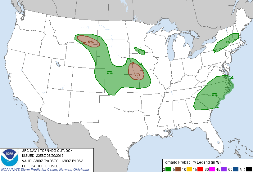
Probabilistic Tornado Graphic
Probability of a tornado within 25 miles of a point. Hatched Area: 10% or greater probability of EF2 - EF5 tornadoes within 25 miles of a point.
Day 1 Tornado Risk
Area (sq. mi.)
Area Pop.
Some Larger Population Centers in Risk Area
5 %
45,821
2,584,171
Kansas City, MO...Omaha, NE...Lincoln, NE...Kansas City, KS...Independence, MO...
2 %
349,583
26,016,478
Charlotte, NC...Virginia Beach, VA...Raleigh, NC...Norfolk, VA...Greensboro, NC...
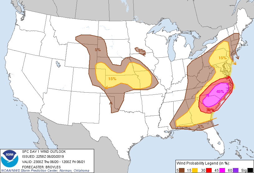
Probabilistic Damaging Wind Graphic
Probability of damaging thunderstorm winds or wind gusts of 50 knots or higher within 25 miles of a point. Hatched Area: 10% of greater probability of wind gusts 65 knots or greater within 25 miles of a point.
Charlotte, NC...Virginia Beach, VA...Norfolk, VA...Greensboro, NC...Chesapeake, VA...
15 %
295,221
41,626,092
Philadelphia, PA...Baltimore, MD...Washington, DC...Kansas City, MO...Atlanta, GA...
5 %
406,559
56,353,074
New York, NY...Jacksonville, FL...Columbus, OH...Denver, CO...Colorado Springs, CO...
Probabilistic Large Hail Graphic
Probability of hail 1" or larger within 25 miles of a point. Hatched Area: 10% or greater probability of hail 2" or larger within 25 miles of a point.
Day 1 Hail Risk
Area (sq. mi.)
Area Pop.
Some Larger Population Centers in Risk Area
SIG SEVERE
77,651
4,526,175
Kansas City, MO...Omaha, NE...Lincoln, NE...Overland Park, KS...Kansas City, KS...
15 %
275,539
18,088,464
Charlotte, NC...Kansas City, MO...Omaha, NE...Raleigh, NC...Lincoln, NE...
5 %
602,501
97,245,060
New York, NY...Philadelphia, PA...Jacksonville, FL...Columbus, OH...Baltimore, MD...
SPC AC 202258
Day 1 Convective Outlook AMEND 1
NWS Storm Prediction Center Norman OK
0558 PM CDT Thu Jun 20 2019
Valid 202300Z - 211200Z
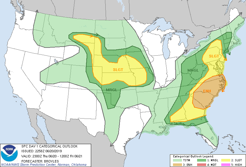
...THERE IS AN ENHANCED RISK OF SEVERE THUNDERSTORMS ACROSS PARTS OF
THE EASTERN U.S....
...THERE IS A SLIGHT RISK OF SEVERE THUNDERSTORMS ACROSS PARTS OF
THE MID MISSOURI VALLEY AND GREAT PLAINS...
AMENDED FOR GRAPHIC LINES
...SUMMARY...
Damaging wind risk continues from southern Virginia to eastern
Georgia this afternoon. The risk for very large hail with a few
tornadoes also persists across parts of the Mid-Missouri Valley this
afternoon into early evening. Otherwise, scattered severe storms
are expected across a broad portion of the central and northern
Great Plains, and over the eastern states.
...Discussion...
No substantive changes are being made to the ongoing outlook, as
forecast reasoning, and general areas of greater risk, remain on
track. The greatest change to the existing areas is a decrease in
the expanse of both the MRGL risk area and thunder area over the
southern Plains, where capping is expected to largely hinder
convective risk.
Otherwise, severe risk continues over portions of the Southeast,
where ongoing watches and warnings are in effect. Meanwhile, severe
storms are expected to develop from the central and northern high
Plains eastward across the central Plains region later this
afternoon and evening.
..Broyles.. 06/20/2019
.PREV DISCUSSION... /ISSUED 1116 AM CDT Thu Jun 20 2019/
...Southeast and Mid Atlantic States...
A progressive shortwave trough is evident in morning water vapor
imagery over AL, with other minor MCVs farther north over east TN
and WV. These features will track eastward today across much of the
Southeast states and Mid Atlantic region. Strong daytime heating is
occurring over this region, where dewpoints in the 70s will yield
afternoon MLCAPE values of 1000-2000 J/kg. Strong westerly flow
aloft, steep low-level lapse rates, and favorable large-scale
forcing will combine for an active strong/severe thunderstorm event
for this region. Multiple lines and clusters of storms will
traverse the area this afternoon and evening, posing a risk of
damaging winds and some hail.
...Northern PA/NJ/NY into New England...
Persistent cloud cover is limiting heating/destabilization from
northern PA/NJ northward into New England. Despite the limited
thermodynamic environment, model guidance and recent radar trends
suggest the potential for scattered afternoon thunderstorms.
Forecast soundings show very favorable vertical shear profiles for
organized or even rotating storms capable of gusty winds and perhaps
a tornado. However, given the weak CAPE profiles, it appears that
the severe risk in this area will remain widely spaced and primarily
marginal. Nevertheless, have extended the SLGT risk area northward
into central NY ahead of ongoing strong activity.
...NE/IA/KS/MO...
A well-defined shortwave trough is moving across SD/NE this morning.
12z model guidance provides continued confidence that a cluster of
intense storms will continue to develop/evolve with this feature
over northeast NE and track southeastward into parts of IA/MO/KS.
These storms may produce very large hail and damaging winds. This
corridor may require an upgrade to ENH at 20z once mesoscale details
become more clear on the evolution of the cluster of storms.
...Northern and Central High Plains...
Strong heating is occurring today from southeast MT into eastern WY
and far eastern CO, where dewpoints in the mid 40s to lower 50s and
steep mid-level lapse rates are present. Scattered thunderstorms
are expected to develop along this axis by mid/late afternoon -
spreading eastward through the evening. Forecast soundings show
favorable vertical shear profiles for a few supercells capable of
large hail and damaging winds. An isolated tornado or two is also
possible. The activity which forms in eastern CO/western KS appears
to have the best chance of persisting deep into the evening and
spreading farther east across KS.
CLICK TO GET WUUS01 PTSDY1 PRODUCT
NOTE: THE NEXT DAY 1 OUTLOOK IS SCHEDULED BY 0100Z