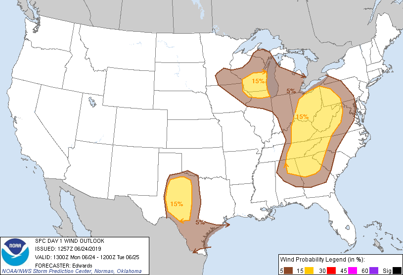
Probability of damaging thunderstorm winds or wind gusts of 50 knots or higher within 25 miles of a point. Hatched Area: 10% of greater probability of wind gusts 65 knots or greater within 25 miles of a point.
San Antonio, TX...Detroit, MI...Indianapolis, IN...Columbus, OH...Charlotte, NC...
SPC AC 241257
Day 1 Convective Outlook
NWS Storm Prediction Center Norman OK
0757 AM CDT Mon Jun 24 2019
Valid 241300Z - 251200Z
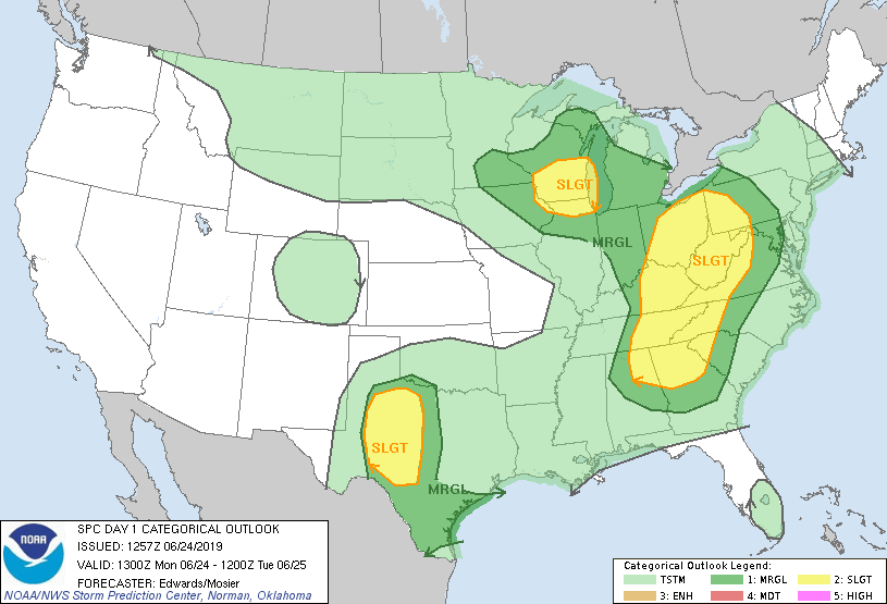
...THERE IS A SLIGHT RISK OF SEVERE THUNDERSTORMS OVER PARTS OF
NORTHERN ILLINOIS/SOUTHERN WISCONSIN AND VICINITY...OVER PARTS OF
THE CENTRAL/SOUTHERN APPALACHIANS AND OHIO VALLEY...AND OVER SOME OF
WEST-CENTRAL/SOUTHWEST TEXAS....
...SUMMARY...
Scattered storms, some severe with hail or wind, are expected today
over parts of northern Illinois/southern Wisconsin and vicinity,
over parts of the central/southern Appalachians and Ohio Valley, and
over some of west-central/southwest Texas.
...Synopsis...
The upper-air pattern will become less-amplified over most of the
CONUS through tomorrow morning. A leading trough -- now located
from the eastern Dakotas to the Arklatex -- will eject northeastward
past the mid/upper Mississippi Valley by 00Z, then across the upper
Great lakes overnight. A Pacific cyclone will dig southward from the
eastern gulf of Alaska to well offshore from the Northwest. Largely
zonal flow will prevail in between, from the northern Pacific Coast
across the central/northern Great Plains.
At the surface, 11Z analysis showed an occluded low over the Apostle
Islands area between DLH-IWD, with triple point over southwestern
WI, and cold front across eastern IA, southwestern MO, eastern OK,
and west-central TX. The southern Plains portion of the front
should stall and then retreat northward today, while a dryline to
its south over northwestern Chihuahua develops northward over
west-central/northwest TX. The northern part of the front will move
slowly eastward over the WI/northern IL region.
An extensive arc of thunderstorms overnight has left an outflow
boundary from middle TN across extreme eastern MS, southeaster LA,
the upper TX Coast near GLS, between AUS-SAT, northwestward across
the Hill Country to between SJT-COM. Though virtually its entire
arc still remains expansive (progressive) at this hour, ongoing and
expected further weakening of supportive convection should slow the
boundary and make the cold pool more shallow behind it, with
stalling and northward retreat likely over central TX prior to the
afternoon convective cycle. The eastern part of the outflow arc
still has a broad area of trailing precip and is oriented more
orthogonally to the flow aloft, and should progress eastward across
northern AL, KY, TN, and the lower Ohio Valley through at least
early/mid afternoon.
...Ohio Valley/Appalachians...
Scattered thunderstorms should develop well ahead of the surface
cold front -- predominantly near the outflow arc and related
corridor of relatively maximized ascent, but also in the warm sector
near outflow/differential-heating boundaries. Activity should move
generally northeastward as clustered to linear multicells, with
isolated supercells possible. The main concern will be damaging to
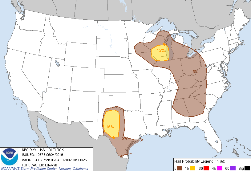
severe gusts, though isolated, marginally severe hail also may
occur.
The 12Z RAOBS ahead of the outflow arc sampled a richly moist
boundary layer underlying variable mid/upper-level lapse rates that
generally steepened with southward extent. Surface dew points in
the mid 60s to low 70s F should combine with favorable diurnal
heating to enable MLCAPE 500-1500 J/kg to develop, locally near 2000
J/kg across parts of AL/GA. Deep shear generally will increase
northward. A broad area of convective/severe potential is apparent,
through coverage is unlikely to be uniform within this swath before
activity generally diminishes this evening.
...IL/WI...
Scattered thunderstorms are expected to develop mainly during the
afternoon in a weakly capped air mass, offering sporadic damaging
winds and severe hail. The threat should diminish with time this
evening, and with eastward extent across Lake Michigan.
Time series of forecast soundings reasonably suggest steepening of
mid/upper-level lapse rates through the afternoon as the trough and
its DCVA field approaches, conterminous with a rising tropopause and
diurnal heating of the boundary layer. These factors will combine
with adequate low-level moisture (e.g., surface dew points 60s F) to
produce MLCAPE commonly in the 1000-1500 J/kg range, locally briefly
near 2000 J/kg. Strong upper-level/ventilating winds will overlie
meager and nearly unidirectional low/middle-level flow, leading to a
vertical kinematic profile supporting organized multicells, small
bows, and short-lived supercell structures. Lift will be maximized
near a weak front/trough in the low levels, moving eastward across
the outlook area.
...West-central/southwest TX...
Widely scattered thunderstorms are expected to develop this
afternoon near the dryline, along and south of its intersection with
the outflow boundary. Damaging gusts and large hail are possible.
In the absence of substantial upper-level perturbations, low-level
thermodynamic processes and lift, followed by storm-scale cold-pool
aggregation, will drive the convective processes today. A wedge of
relatively undisturbed moist sector, between the dryline and outflow
arc, will be strongly heated this afternoon, removing most or all
MLCINH such that only modest lift along the boundaries will be
needed to generate convection. With surface dewpoints commonly in
the upper 60s to mid 70s F, and mid/upper-level lapse rates
remaining relatively steep for this area and time of year, peak
preconvective MLCAPE values of 4000-5000 J/kg are likely, locally
higher. Weak low/middle-level winds will limit vertical shear
overall and keep hodographs small, contributing to predominantly
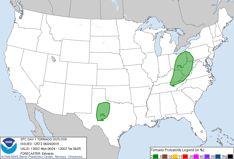
multicellular storm organization. Still, a tornado cannot be
completely ruled out, given stretching potential attendant to the
large/deep buoyancy, and residual low-level vorticity near the
outflow boundary. Some clustering of convection may occur for a few
hours, which would boost local severe-wind potential. Overall
convective/severe threat should wane with time late this evening as
diurnally generated convective outflows spread into a cooling
boundary layer.
..Edwards/Mosier.. 06/24/2019
CLICK TO GET WUUS01 PTSDY1 PRODUCT
NOTE: THE NEXT DAY 1 OUTLOOK IS SCHEDULED BY 1630Z