SPC AC 180552
Day 2 Convective Outlook
NWS Storm Prediction Center Norman OK
1252 AM CDT Thu Apr 18 2019
Valid 191200Z - 201200Z
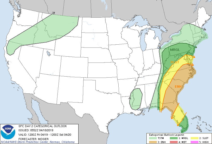
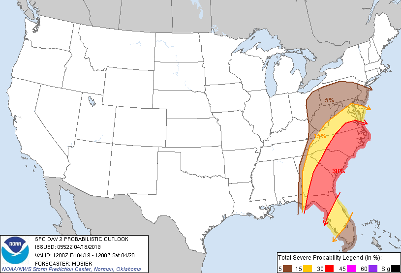
...THERE IS AN ENHANCED RISK OF SEVERE THUNDERSTORMS FROM NORTHERN
FLORIDA THROUGH THE MID-ATLANTIC STATES...
...SUMMARY...
Numerous thunderstorms are possible from the Mid-Atlantic States
southward to Florida on Friday. Some of these storms will be capable
of producing damaging wind gusts. A few tornadoes are also possible.
...Synopsis...
Deep upper trough extending along the MS Valley at the beginning of
the period will continue eastward on Friday while deepening and
maturing. Resulting mid-latitude cyclone will move across TN and
northern portions of MS and AL, continuing eastward and ending the
period over the southern Appalachians. A strong and expansive wind
field will accompany this mid-latitude cyclone, with strengthening
expected as it spreads across the Mid-Atlantic States. By 00Z, a
corridor of 100+ kt 500-mb winds will likely extend from GA into
southwest VA while a corridor of 50+ kt 850-mb winds exists from
just off the Southeast coast northward into southern NJ/southeast
PA.
...Northern/Central Florida...Southeast GA...
Mature convective line is expected to extend from northwest GA into
the central FL Panhandle at the beginning of the period. Given the
displacement north of the better low-level moisture and instability,
northern portion of this line will likely be weak and unorganized.
However, ample low-level moisture and sufficient instability will
exist across southern GA and adjacent portions of the FL Panhandle.
Additionally, strong low- to mid-level flow will also be in place,
supporting large, looping low-level hodographs and robust vertical
shear. These factors suggest the convective line will maintain an
organized structure and vigorous updrafts capable of damaging wind
gusts as it moves eastward across southern GA and northern FL.
Line-embedded tornadoes are possible as well. The forcing for ascent
will gradually lift north throughout the day and the expectation is
for the line to begin weakening as it enters the central FL
Peninsula during the late afternoon.
...Mid-Atlantic States...
Northern portion of the convective line moving into GA at the
beginning of the period will likely be poorly organized, largely a
result of weak instability. Gradual re-intensification of this line
appears probable as it continues eastward into better low-level
moisture, higher instability, and a strengthening low-level jet.
Some potential exists for this redevelopment to occur with more
orthogonal orientation to the deep shear vector. All of these
factors suggest a well-organized convective line capable of damaging
wind gusts will move across the Carolinas. Given the strength of the
flow and at least some potential for backing of the surface winds,
embedded tornadoes are also possible.
Open warm-sector storms may also develop, with bowing line segments
as the predominant convective mode. Any more persistent/organized
storms could pose a risk for damaging wind gusts and a tornado or
two.
...Upper OH Valley...
Thunderstorms will likely develop during the afternoon near the
surface low moving through OH. Instability will be limited but a few
stronger storms could produce damaging wind gusts and/or hail.
...MAXIMUM RISK BY HAZARD...
Tornado: 5% - Slight
Wind: 30% - Enhanced
Hail: 15% - Slight
..Mosier.. 04/18/2019
CLICK TO GET WUUS02 PTSDY2 PRODUCT
NOTE: THE NEXT DAY 2 OUTLOOK IS SCHEDULED BY 1730Z