Kansas City, MO...Overland Park, KS...Kansas City, KS...Topeka, KS...Olathe, KS...
MARGINAL
294,351
28,497,189
Columbus, OH...Oklahoma City, OK...Cleveland, OH...Tulsa, OK...Wichita, KS...
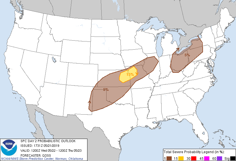
Probabilistic Graphic
Probability of severe weather within 25 miles of a point. Hatched Area: 10% or greater probability of significant severe within 25 miles of a point.
Day 2 Prob. Risk
Area (sq. mi.)
Area Pop.
Some Larger Population Centers in Risk Area
15 %
26,622
2,865,230
Kansas City, MO...Overland Park, KS...Kansas City, KS...Topeka, KS...Olathe, KS...
5 %
293,738
28,547,586
Columbus, OH...Oklahoma City, OK...Cleveland, OH...Tulsa, OK...Wichita, KS...
SPC AC 211731
Day 2 Convective Outlook
NWS Storm Prediction Center Norman OK
1231 PM CDT Tue May 21 2019
Valid 221200Z - 231200Z
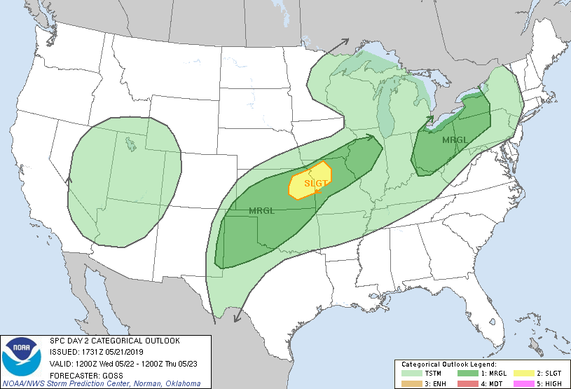
...THERE IS A SLIGHT RISK OF SEVERE THUNDERSTORMS ACROSS PORTIONS OF
EASTERN KANSAS/NORTHWESTERN MISSOURI...
...SUMMARY...
Thunderstorms capable of mainly large hail are possible Wednesday
night into early Thursday morning from the central Plains into the
middle Mississippi Valley, and possibly southwestward across
Oklahoma to the southern High Plains. A few strong storms with gusty
winds and hail will also be possible over a portion of the Ohio
Valley.
...Synopsis...
As an upper low initially progged over the northern Plains weakens
and drifts northeast across the upper Mississippi Valley toward the
Upper Great Lakes/Ontario with time, a second low is forecast to
expand/deepen over the Intermountain West with time. As this
evolution occurs, height rises are progged across much of the
eastern half of the U.S. as ridging over the southeastern U.S./Gulf
of Mexico expands in the wake of the departing northern Plains low.
At the surface, a weakening baroclinic zone is forecast to linger
from the Midwest west-southwestward to the Texas Panhandle vicinity
as the old/occluded low drifts toward the upper Mississippi Valley.
Otherwise, a broad area of low pressure is progged over the west in
conjunction with the upper low, while high pressure prevails over
the east.
...Southern High Plains northeast to the mid Mississippi Valley
area...
In the wake of the departing upper low, and ahead of the
second/developing low over the West, ridging/subsidence will largely
prevail over the southern Plains and vicinity. Still, returning
moisture combined with daytime heating will result in substantial
destabilization -- though capping, stemming from the aforementioned
ridging/subsidence -- will most likely preclude daytime convective
development. Some hints that a few storms could initiate over the
Oklahoma vicinity are indicated -- apparently tied to a very weak
mid-level disturbance moving through the otherwise anticyclonic flow
-- but this appears very low probability at this time. Should a
storm or two initiate however, the background CAPE/shear environment
would be quite supportive for supercell storms -- and all severe
hazards. At this time, will expand the 5% risk across Oklahoma, for
what still appears to be a highly conditional scenario at best.
Later in the evening/overnight, increasing warm advection should
support storm development a bit farther northeast, as the
aforementioned disturbances moves into eastern Kansas/western
Missouri. With storms most likely to develop in the zone of warm
advection to the cool side of the remnant front, large hail with a
few of the stronger/rotating storms would appear the most likely
risk.
...Upper Ohio Valley...
Weakening/remnant convection is progged to be moving across the
Midwest/mid Mississippi Valley at the start of the period, ahead of
the weak surface front. As some heating/destabilization of a
relatively moist boundary layer over the mid and upper Ohio Valley
occurs, an afternoon uptick in convective coverage/intensity may
occur, though likely tempered to some degree by background ridging
aloft. Still, with amply strong mid-level west-southwesterlies
supportive of some organization and fast-moving storms, risk for
locally damaging winds -- and possibly hail -- will exist with a
couple of the strongest cells, from afternoon into the evening.
Convection should weaken as it reaches the Appalachians during the
evening.
...MAXIMUM RISK BY HAZARD...
Tornado: 2% - Marginal
Wind: 5% - Marginal
Hail: 15% - Slight
..Goss.. 05/21/2019
CLICK TO GET WUUS02 PTSDY2 PRODUCT
NOTE: THE NEXT DAY 2 OUTLOOK IS SCHEDULED BY 0600Z