New York, NY...Indianapolis, IN...Kansas City, MO...Cleveland, OH...Omaha, NE...
SPC AC 221807
Day 2 Convective Outlook CORR 1
NWS Storm Prediction Center Norman OK
0107 PM CDT Wed May 22 2019
Valid 231200Z - 241200Z
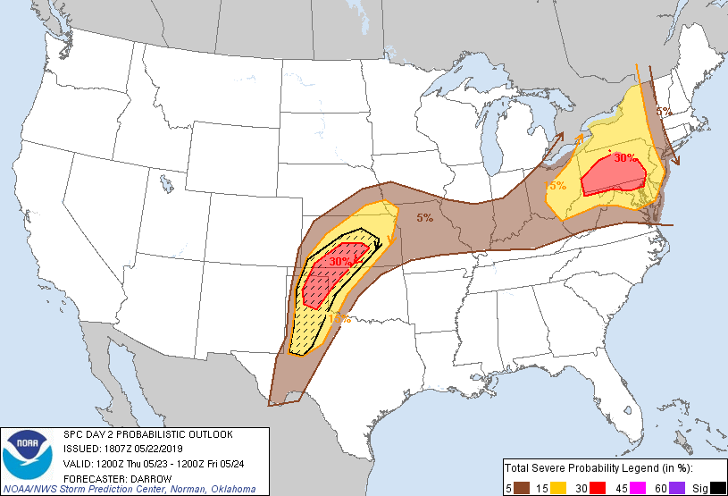
...THERE IS AN ENHANCED RISK OF SEVERE THUNDERSTORMS ACROSS THE OH
VALLEY/MIDDLE ATLANTIC AND SOUTHERN/CENTRAL PLAINS...
CORRECTED FOR MISSING THUNDER LINE
...SUMMARY...
Severe storms with large hail, damaging wind and tornadoes will be
possible over a part of the central and southern Plains Thursday.
Other severe storms with a threat for mainly damaging wind and large
hail are expected from a portion of the Ohio Valley into the
northern Middle Atlantic.
...Upper OH Valley/Northern Middle Atlantic...
Central US short-wave trough is forecast to eject northeast across
the Great Lakes and flatten the eastern ridge as 80kt 500mb speed
max translates across Lake Erie. This feature is expected to aid
early-morning convection across the OH Valley which will propagate
into eastern OH/western PA by 18z. Depending on the evolution of
this convection it appears environmental shear will become favorable
for sustaining fast-moving organized updrafts. Latest model guidance
suggests upward-evolving thunderstorms by early afternoon within
strengthening westerly flow regime. Boundary-layer heating is
expected to be maximized from south-central PA, south along the lee
of the central Appalachians. If a cold pool develops early, severe
thunderstorms should initiate along the
eastern-southern-southwestern flank of this activity then
spread/develop east-southeast toward the Delmarva. Several CAMs
solutions support this scenario and will extend higher severe probs
into northern MD to account for the more southeast propagational
component. Damaging winds, and some hail, are expected with
convection as it spreads across eastern OH/PA toward northern MD by
late afternoon.
...Central/Southern Plains...
Strong mid-level flow is forecast to round the base of western US
trough over northern Mexico late day1 into early day2, then
translate into the central High Plains by 24/00z. In response to
this feature, LLJ should strengthen across the TX south Plains late
Wednesday. This will allow for a substantial moisture surge to at
least 102W longitude where higher terrain and heating along the
western edge of this moist plume should contribute to robust
convection. There is some concern that convection could develop
early in the period along the nose of the LLJ. This activity is most
likely across the northern TX Panhandle into western KS atop cooler
boundary air mass that will sag south across the High Plains. This
early-day convection will likely be elevated and pose primarily a
large hail threat. However, strong surface heating near the NM/TX
border will contribute to substantial buoyancy that will become
uncapped by late afternoon. Forecast shear profiles strongly favor
supercells and a fair number of storms should ultimately evolve
across the ENH Risk. High-PW air mass should surge into this region
such that long-lived supercells are expected. Very large hail and
tornadoes can be expected with supercells south of the cold front
that will orient itself across southwest-central KS. If early-day
convection is less than currently expected, a corridor of higher
severe probs may ultimately need to be considered across the High
Plains south of the front.
...MAXIMUM RISK BY HAZARD...
Tornado: 10% - Enhanced
Wind: 30% - Enhanced
Hail: 30% SIG - Enhanced
..Darrow.. 05/22/2019
CLICK TO GET WUUS02 PTSDY2 PRODUCT
NOTE: THE NEXT DAY 2 OUTLOOK IS SCHEDULED BY 0600Z