Kansas City, MO...Tulsa, OK...Wichita, KS...Pittsburgh, PA...Lincoln, NE...
SLIGHT
260,077
34,885,255
Philadelphia, PA...Oklahoma City, OK...Cleveland, OH...Omaha, NE...St. Louis, MO...
MARGINAL
243,583
60,066,465
New York, NY...Chicago, IL...Dallas, TX...Detroit, MI...Indianapolis, IN...
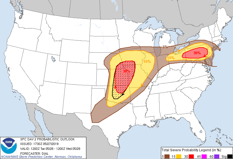
Probabilistic Graphic
Probability of severe weather within 25 miles of a point. Hatched Area: 10% or greater probability of significant severe within 25 miles of a point.
Day 2 Prob. Risk
Area (sq. mi.)
Area Pop.
Some Larger Population Centers in Risk Area
SIG SEVERE
90,538
7,287,914
Oklahoma City, OK...Kansas City, MO...Tulsa, OK...Wichita, KS...Lincoln, NE...
30 %
107,003
13,592,805
Kansas City, MO...Tulsa, OK...Wichita, KS...Pittsburgh, PA...Lincoln, NE...
15 %
259,222
34,872,365
Philadelphia, PA...Oklahoma City, OK...Cleveland, OH...Omaha, NE...St. Louis, MO...
5 %
244,911
59,848,044
New York, NY...Chicago, IL...Dallas, TX...Detroit, MI...Indianapolis, IN...
SPC AC 271730
Day 2 Convective Outlook
NWS Storm Prediction Center Norman OK
1230 PM CDT Mon May 27 2019
Valid 281200Z - 291200Z
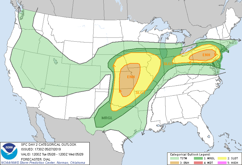
...THERE IS AN ENHANCED RISK OF SEVERE THUNDERSTORMS FROM A PORTION
OF THE SOUTHERN AND CENTRAL PLAINS TO THE UPPER MIDWEST AS WELL AS
FROM OHIO INTO PENNSYLVANIA...
...SUMMARY...
Severe storms (capable of large hail, damaging wind and tornadoes)
are possible Tuesday from the central and southern Plains eastward
to the Midwest. Severe storms with large hail, damaging wind and a
couple of tornadoes are also possible from the Ohio Valley into a
portion of the Northeast States Tuesday afternoon and early evening.
...Synopsis...
A low-amplitude shortwave trough will move off the northeast coast
Tuesday morning, while upstream a more significant upper trough will
move into the central Plains before continuing northeast into the
upper MS Valley region Tuesday night. By 12Z Tuesday the surface
pattern should be characterized by a warm front from eastern PA
northwest to a surface low over the Great Lakes. A cold or
stationary front will trail southwestward from this low to another
area of low pressure over the central Plains. A dryline/Pacific
front will extend southward from the central Plains low through
western KS and western TX.
...Southern and central Plains through the upper Midwest...
Rich low-level moisture with upper 60s to around 70F dewpoints will
reside in the warm sector beneath 7-8 C/km mid-level lapse rates
associated with the eastward expansion of the elevated mixed layer.
Some areas of stratus may reside across a portion of this region,
but should mix out by late morning to early afternoon, with diabatic
warming further contributing to destabilization with MLCAPE from
2000-3000 J/kg likely. Warm air at the base of the EML will likely
result in at least a modest cap in much of the warm sector. By mid
afternoon, forcing attending a mid-level jet moving northeast
through the base of the upper trough should result in storm
initiation along the Pacific front from south central NE through
central KS and possibly as far south as western OK. Some CAMs also
indicate a separate area of storm development along a portion of
the warm conveyor belt from eastern KS into MO and southern IA.
Wind profiles with 40-50 kt effective bulk shear will support
supercells as the initial storm mode, but some storms will
eventually evolve into linear MCSs. While low-level hodographs are
forecast to remain modest most of the day, 0-1 km helicity should
increase by early evening as the low-level jet strengthens. Large
hail and damaging wind will be the main threats, but a window for
tornadoes will exist especially from late afternoon through early
evening. Overnight, most storms will have evolved into lines or
clusters, but will continue to pose a severe threat as they continue
east through the upper Midwest, mainly within zone of ascent along
and just north of the stationary front.
...Ohio Valley into a portion of the northeast States...
An area of rain and thunderstorms developing within zone of
isentropic ascent on the cool side of a warm front and in
association with a low-amplitude shortwave trough, will move through
a portion of the Northeast States early in the day. In wake of this
activity surface dewpoints in the upper 60s will advect eastward
through the warm sector contributing to moderate instability
(1500-2000 J/kg MLCAPE) as the boundary layer warms during the
afternoon. Forecast soundings indicate at least a weak inversion
associated with the eastern extension of the elevated mixed layer.
However, storms will likely initiate along the stationary front as
well as lake breezes and spread southeast through the warm sector.
This region will remain within zone of moderate westerlies with
35-45 kt effective bulk shear supportive of organized storms
including supercells and bowing line segments. Damaging wind and
large hail will be the main threats with this activity, but a couple
of tornadoes will also be possible through early evening.
...MAXIMUM RISK BY HAZARD...
Tornado: 10% - Enhanced
Wind: 30% - Enhanced
Hail: 30% SIG - Enhanced
..Dial.. 05/27/2019
CLICK TO GET WUUS02 PTSDY2 PRODUCT
NOTE: THE NEXT DAY 2 OUTLOOK IS SCHEDULED BY 0600Z