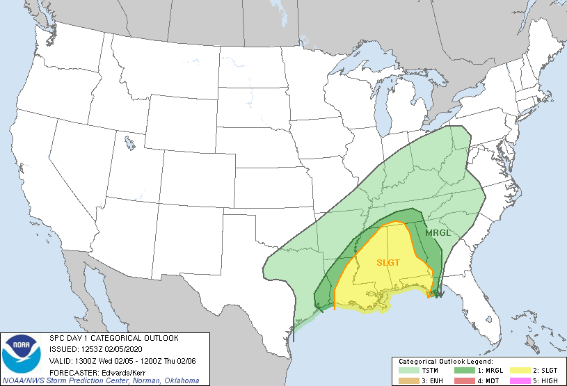
New Orleans, LA...Birmingham, AL...Baton Rouge, LA...Montgomery, AL...Mobile, AL...
MARGINAL
76,761
9,196,130
Atlanta, GA...Columbus, GA...Chattanooga, TN...Beaumont, TX...Sandy Springs, GA...
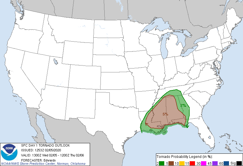
Probabilistic Tornado Graphic
Probability of a tornado within 25 miles of a point. Hatched Area: 10% or greater probability of EF2 - EF5 tornadoes within 25 miles of a point.
Day 1 Tornado Risk
Area (sq. mi.)
Area Pop.
Some Larger Population Centers in Risk Area
5 %
116,948
10,313,752
New Orleans, LA...Birmingham, AL...Baton Rouge, LA...Montgomery, AL...Mobile, AL...
2 %
72,999
9,289,871
Atlanta, GA...Columbus, GA...Chattanooga, TN...Sandy Springs, GA...Murfreesboro, TN...
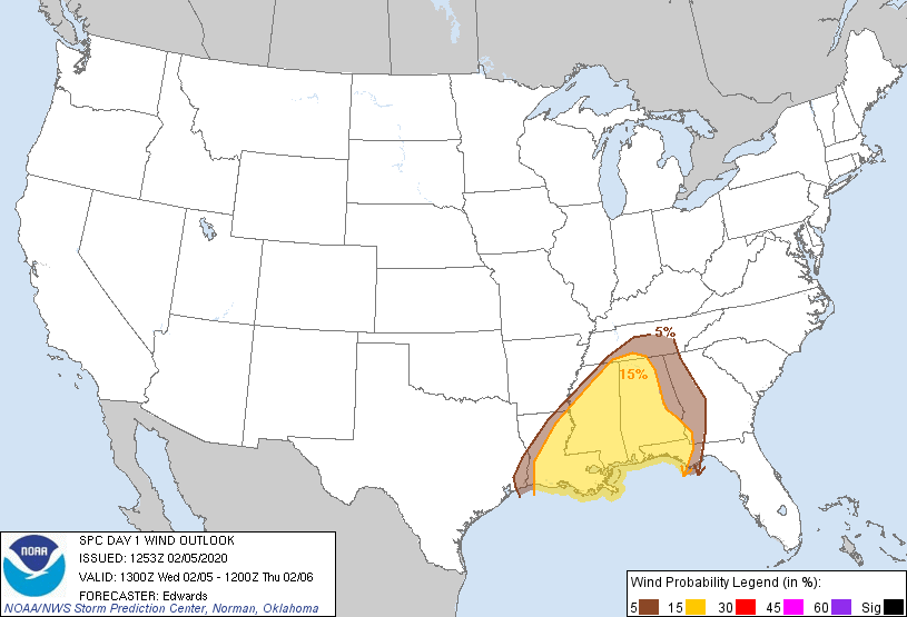
Probabilistic Damaging Wind Graphic
Probability of damaging thunderstorm winds or wind gusts of 50 knots or higher within 25 miles of a point. Hatched Area: 10% of greater probability of wind gusts 65 knots or greater within 25 miles of a point.
Day 1 Wind Risk
Area (sq. mi.)
Area Pop.
Some Larger Population Centers in Risk Area
15 %
135,506
11,310,263
New Orleans, LA...Birmingham, AL...Baton Rouge, LA...Montgomery, AL...Mobile, AL...
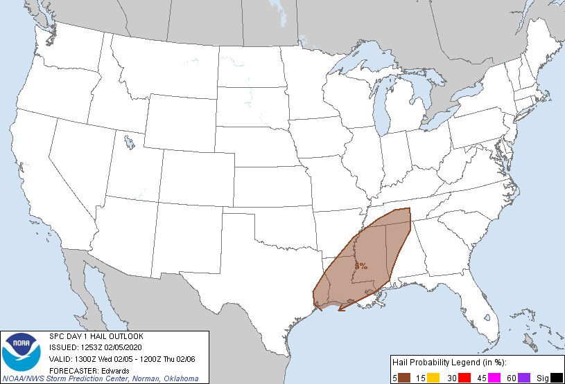
5 %
57,772
8,586,036
Atlanta, GA...Columbus, GA...Chattanooga, TN...Beaumont, TX...Sandy Springs, GA...
Probabilistic Large Hail Graphic
Probability of hail 1" or larger within 25 miles of a point. Hatched Area: 10% or greater probability of hail 2" or larger within 25 miles of a point.
   SPC AC 051253

   Day 1 Convective Outlook
   NWS Storm Prediction Center Norman OK
   0653 AM CST Wed Feb 05 2020

   Valid 051300Z - 061200Z

   ...THERE IS A SLIGHT RISK OF SEVERE THUNDERSTORMS TODAY AND TONIGHT
   ACROSS PORTIONS OF THE LOWER MISSISSIPPI VALLEY AND SOUTHEAST...

   ...SUMMARY...
   Severe thunderstorms are expected today and tonight across portions
   of the lower Mississippi Valley and Southeast, with damaging wind
   gusts and a few tornadoes.

   ...Synopsis...
   The CONUS mid/upper-level pattern will be dominated by a major
   synoptic trough -- initially extending from the Dakotas across CO to
   northwestern MX -- and associated broadly cyclonic to southwesterly
   flow to its east.  The trough should move eastward gradually,
   maintaining net positive tilt, as several shortwaves pivot through
   it.  By 12Z tomorrow, the trough should extend from the upper
   Mississippi Valley across OK to north-central/central MX.  Mid/upper
   level southwesterlies (in the 500-250-mb layer) will intensify east
   of the trough tonight, in a fetch from the TX Gulf Coast to the
   upper Great Lakes.

   Meanwhile, a strong but slow-moving surface cold front was analyzed
   at 11Z from southern WV across eastern KY, becoming quasistationary
   southwestward to a weak frontal-wave low between SHV-ESF, then a
   cold front again across extreme southeast TX and the upper TX Coast,
   to deep south TX.  By 00Z, the low should ripple northeastward over
   northern MS and western/middle TN, and the front should extend from
   there to south-central LA and the northwestern Gulf.  By 12Z, the
   front should be located across eastern TN, central AL and
   southeastern LA.  A diffuse marine/warm front -- demarcating the
   northern rim of best-modified boundary-layer air from the Gulf --
   will spread inland across MS and much of AL, reaching southwestern
   GA and the central FL Panhandle overnight.

   ...Southeast...
   Episodic thunderstorm areas are forecast to move northeastward
   across the region through tomorrow morning, offering the potential
   for damaging winds and a few tornadoes.

   At this time, the potential appears to be focused best in three
   stages:
   1.  Prefrontal/warm-sector convection developing inland over MS and
   into parts of northwestern AL during the day, as the air mass
   gradually destabilizes from a combination of slow/diffuse diurnal
   heating and boundary-layer theta-e advection.  A persistent cone of
   low-level confluent flow, with associated convergence amidst
   weakening MLCINH, will support this activity.  Mixed, potentially
   messy storm modes are possible, along with some initially discrete
   or embedded supercells, with flow aloft being largely parallel to
   the zone of ascent.
   2.  Convection developing near the marine/warm front and farther
   south into the optimally moist/high-theta-e Gulf warm sector this
   afternoon into overnight.  Coverage is very uncertain in this regime
   due to the combination of weak CINH and weak forcing for ascent, but
   some sustained/discrete storms are possible.
   3.  Near-frontal thunderstorms this afternoon through overnight --
   initially over parts of LA/southeastern AR/MS and filling in
   overnight as the frontal zone crosses the outlook area.  Confidence
   is greatest in relatively dense (scattered to numerous) storm
   coverage in this regime, which also is likely to assume messy/quasi-
   linear mode with time beneath nearly front-parallel flow.  Still,
   embedded supercells, bows and QLCS circulations will maximize severe
   potential locally.
   Convective coverage and longevity are still quite unclear,
   especially in the first two regimes, given the "CAPE robber" stable
   layer evident in midlevels in the 12Z LIX/JAN RAOBs, but not
   upstream at LCH.

   The warm sector will be characterized by increasing moisture/
   buoyancy with southward extent toward the coast, favorable low-level
   and deep shear area-wide, and stronger lift over northern and
   frontal areas.  Forecast soundings reasonably depict a broad area of
   1000-2000 J/kg MLCAPE -- supported by surface dew points in the 60s
   F, PW around 1.5 inches, and mean mixing ratios generally in the
   13-15 g/kg range.  Effective-shear magnitudes of 50-60 kt and
   200-400 J/kg effective SRH should be rather common, which would
   support tornado threats with any sustained/discrete cells, and
   conditionally, significant-tornado potential given the parameter
   space involved.  Some subset of this broad risk area may be upgraded
   once 12Z+ progs have arrived, and mesoscale trends become more
   certain.

   ..Edwards/Kerr.. 02/05/2020

   CLICK TO GET WUUS01 PTSDY1 PRODUCT

   NOTE: THE NEXT DAY 1 OUTLOOK IS SCHEDULED BY 1630Z