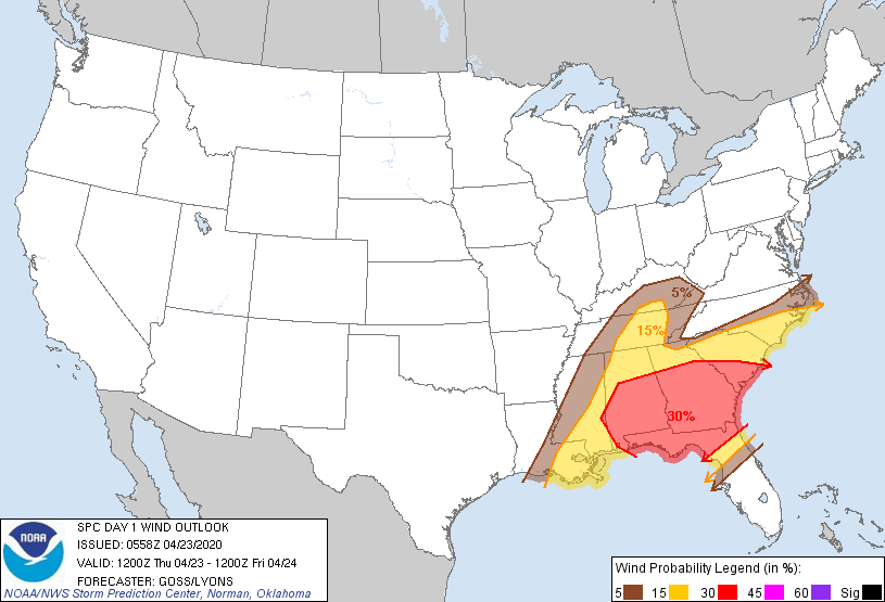
Probability of damaging thunderstorm winds or wind gusts of 50 knots or higher within 25 miles of a point. Hatched Area: 10% of greater probability of wind gusts 65 knots or greater within 25 miles of a point.
SPC AC 230558
Day 1 Convective Outlook
NWS Storm Prediction Center Norman OK
1258 AM CDT Thu Apr 23 2020
Valid 231200Z - 241200Z
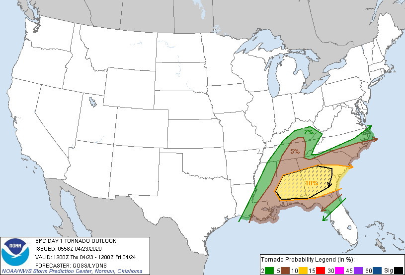
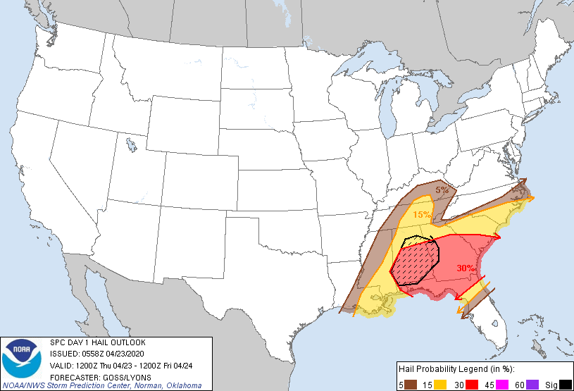
...THERE IS AN ENHANCED RISK OF SEVERE THUNDERSTORMS FROM PARTS OF
FAR EASTERN MISSISSIPPI EAST ACROSS PARTS OF ALABAMA...SOUTHERN
GEORGIA...NORTHERN FLORIDA AND THE FLORIDA PANHANDLE...TO SOUTHERN
SOUTH CAROLINA...
...SUMMARY...
Severe thunderstorms are expected across a large portion of the
Southeast Thursday through Thursday night, including the potential
for a few strong tornadoes along with damaging winds and large hail.
...Synopsis...
Between a pair of low-amplitude ridges near the West and East
Coasts, broadly cyclonic flow aloft will prevail across the U.S.
through the period. Within this broad cyclonic regime, a short-wave
trough is forecast to move steadily eastward across the southeastern
quarter of the country.
At the surface, a low -- initially expected to lie in the vicinity
of the Ozarks -- will move east into the Tennessee Valley area by
late afternoon/early evening, and then east-northeastward across the
central Appalachians. A trailing cold front will sweep across the
Southeast, while a wedge/damming front will be slow to retreat
across the Carolinas.
...The Southeast...
A somewhat complex/messy scenario is unfolding for today, as
widespread convection currently spreading across the mid and lower
Mississippi Valley into parts of Tennessee, Mississippi, and Alabama
will continue moving eastward early this morning. By 12Z, the
strongest convection -- including some ongoing risk for severe
weather -- should extend west-southwestward from east-central
Alabama to southeast Louisiana.
As diurnal heating/destabilization occurs ahead of the convection,
expect storms to intensify -- likely organizing linearly into bands
of strong/severe storms -- which should sweep across southern
Georgia and the Florida Panhandle/northern Florida, and southern
South Carolina through the afternoon. The storms will be
accompanied by potential for damaging winds, along with large hail
and a few tornadoes.
Meanwhile, in the wake of this convection, it appears that enough
clearing/heating will occur across eastern Mississippi and southeast
Louisiana, and into northern and central Alabama to allow sufficient
airmass recovery/destabilization to occur. Up to 1500 to 2500 J/kg
mixed-layer CAPE may evolve across parts of Mississippi and Alabama,
and up to 300 to 500 J/kg northward across Tennessee and into
central and eastern Kentucky.
As the cold front advances, in conjunction with the short-wave
troughing aloft, this destabilization will allow new storm
development to occur by early afternoon -- from east-central and
southeast Mississippi east into west-central Alabama, and then
northward across the Cumberland Plateau into Kentucky. With
strengthening/veering flow with height providing favorable shear for
supercells, potential for tornadoes will accompany these storms -- a
few of which could be strong. Large hail is also expected, along
with damaging winds.
The convection will continue eastward across Alabama, and eastern
portions of Kentucky and Tennessee through the afternoon, and into
Georgia. However, uncertainty with respect to degree of severe risk
increases with eastward extent across Georgia, due to questions
regarding the degree of airmass recovery which will have occurred in
the wake of earlier storms -- likely still ongoing over northern
Florida. Still, it appears that fairly substantial all-hazard
severe risk will extend into at least central Georgia into the
evening hours, before risk begins to diminish.
...Intermountain Region into the Plains...
Diurnal heating across a large portion of the Intermountain West and
into the Plains is expected today, beneath broad northwesterly flow
aloft. Scant boundary-layer moisture should mix out through the
afternoon, leaving inverted-v thermal profiles at low levels,
beneath a couple hundred J/kg high-based CAPE. Though severe-level
wind gusts are generally not expected, a few stronger gusts -- aided
by evaporative enhancment of downdrafts with a few more robust
storms/storm clusters -- are expected during the afternoon, before
storms weaken into the evening with the onset of diurnal cooling.
..Goss/Lyons.. 04/23/2020
CLICK TO GET WUUS01 PTSDY1 PRODUCT
NOTE: THE NEXT DAY 1 OUTLOOK IS SCHEDULED BY 1300Z