Oklahoma City, OK...Nashville, TN...Clarksville, TN...Norman, OK...Denton, TX...
Probabilistic Damaging Wind Graphic
Probability of damaging thunderstorm winds or wind gusts of 50 knots or higher within 25 miles of a point. Hatched Area: 10% of greater probability of wind gusts 65 knots or greater within 25 miles of a point.
SPC AC 041241
Day 1 Convective Outlook
NWS Storm Prediction Center Norman OK
0741 AM CDT Mon May 04 2020
Valid 041300Z - 051200Z
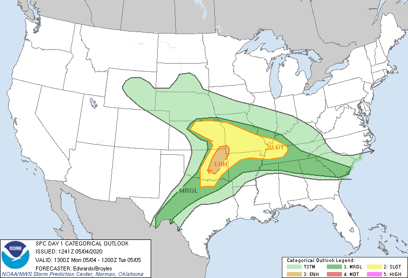
...THERE IS AN ENHANCED RISK OF SEVERE THUNDERSTORMS FROM NEAR THE
MISSOURI/KANSAS/OKLAHOMA BORDER JUNCTION ACROSS PARTS OF EASTERN
OKLAHOMA...
...SUMMARY...
Severe thunderstorms are forecast today in a loosely T-shaped area
concentrated over parts of Oklahoma, Kansas, the Ozarks, and western
Tennessee/Kentucky. All forms of severe weather may occur
(downdraft wind, hail, tornadoes). Very large/damaging hail, over 2
inches across, is possible from the western Ozarks across eastern
Oklahoma.
...Synopsis...
In mid/upper levels, the upper-air pattern is characterized by split
flow around a temporary Rex pattern over northwestern North America,
north of a nearly zonal southern-stream belt from the West Coast
across the central/northern Plains, bending southeastward with
approach to the Atlantic in deference to northeastern CONUS
troughing. A mid/upper-level speed max -- associated with a series
of closely spaced shortwaves/vorticity maxima now over the central
Plains and central Rockies -- will move/develop eastward across the
central Plains to parts of MO today, and the lower Ohio Valley
overnight.
At the surface, 11Z analysis showed a weak surface low near GUY,
with wavy warm front across northern OK to near FSM, then over
central AR and northern MS. A cold front was moving southeastward
across southeastern CO and northwestern KS, reinforced by convective
outflow from prior/overnight activity.
By 00Z, a new surface low should develop near the cold front/warm
front intersection in the western MO/eastern KS area, though
location uncertainty is considerable, given potential mesoscale
convective factors. The cold front then should extend across
northeastern through south-central/southwestern OK, to the southern
TX Panhandle and northeastern NM. The cold front should overtake
the dryline from north-south through the afternoon, so that their
intersection is over southwestern OK by 00Z. The warm front should
reach a position from the low east-southeastward across the MO
Ozarks to western TN, with its effective position potentially
shifted southward locally by convective outflow. By 12Z, the low
should reach the EVV area, with cold front to near a DYR-TXK-JCT-FST
line.
...Central/southern Plains, Ozarks to western TN/KY...
Two primary episodes of severe will affect the broader outlook area,
with some spatial overlap:
1. Evolution of ongoing convection over KS and the related,
initially elevated UVV plume shifting southeastward across MO toward
western portions of TN/KY through the day. A severe-hail threat
already has developed with elevated convection north of the surface
warm front across portions of Kansas. The wind potential will
increase through the morning as more convection forms further south
and east, atop a shallower and less-intense stable layer, with
more-buoyant inflow. Refer to SPC severe thunderstorm watch 161 and
related mesoscale discussions for the near-term threats.
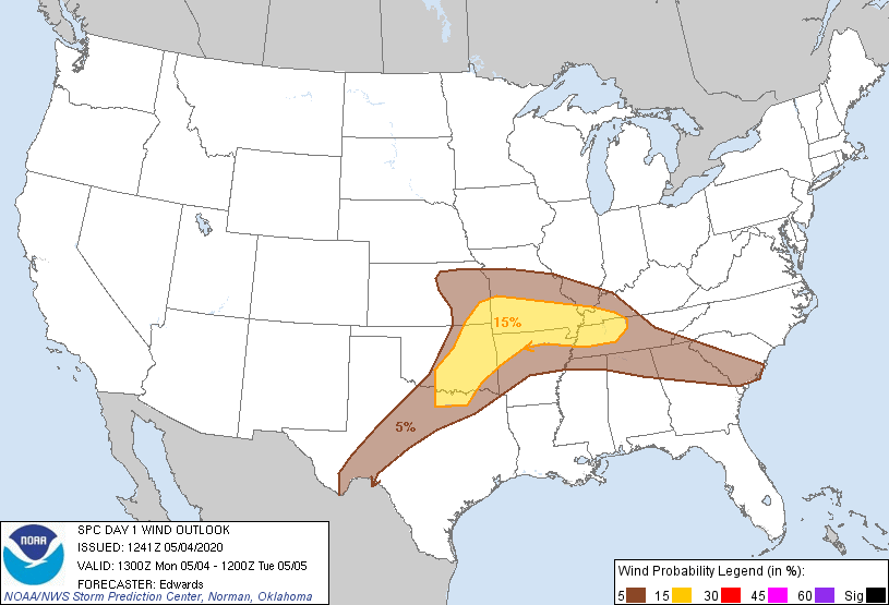
A conditionally greater wind potential may develop near the warm
front, across parts of the Ozarks to western/mid TN this afternoon,
strongly dependent upon sufficient cold-pool aggregation and
organization in upshear convection across southern MO. The surface
warm-frontal zone from southeastern KS toward western TN/KY will
possess backed near-surface winds, greater storm-relative boundary-
layer flow, enlarged hodographs, and maximized low-level vorticity.
This also indicates a conditional corridor of relatively maximized
supercell/tornado threat. The greatest potential offsetting factor
may be those driving the aforementioned wind threat (potential for
cold-pool-driven, clustered or bowed storm mode). For now, the wind
probability and marginal tornado threat have been extended somewhat
southeastward in accordance with these indications.
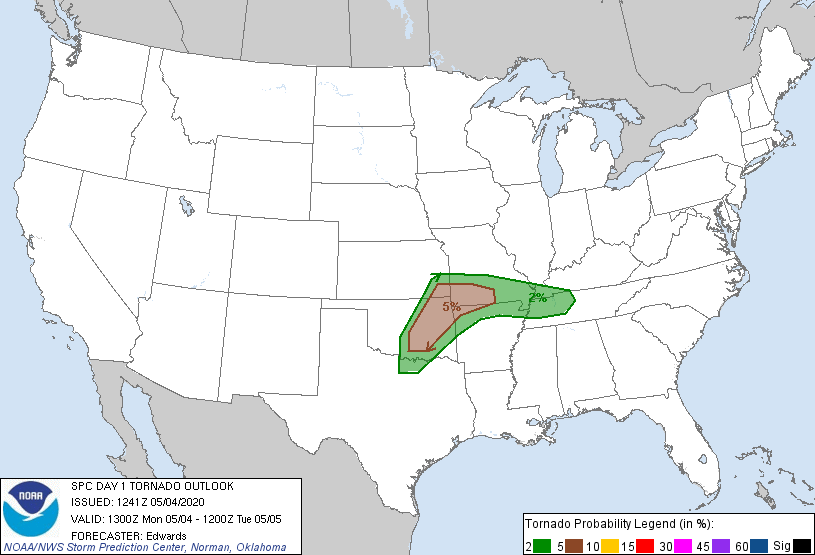
2. Afternoon supercell development along the cold front, with more
isolated/transient multicell to marginal supercell convection
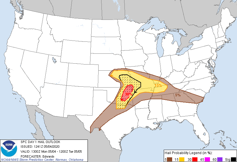
possible along the dryline. The frontal activity should offer
greatest hail threat, both in coverage and size, with the potential
for significant to giant hail 2-4 inches in diameter (locally/
potentially larger), along with severe downdrafts. Some tornado
threat also can be expected from any mature, relatively discrete
supercells that move into the richer moist layer of eastern
OK/northwest AR/southwestern MO/southeastern KS.
Forecast soundings suggest higher LCL with southwestward extent
along the front near projected convection-initiation period mid/late
afternoon. Very steep low/middle-level lapse rates exceeding 8 deg
C/km -- characteristic of the EML -- will overlie a field of dew
points in the mid 60s to low 70s F. This should yield 3500-5500
J/kg MLCAPE as frontal lift breaches a previously stout EML
inversion. Rapid to explosive thunderstorm development is possible,
with extreme updraft speeds, and more than sufficient inflow-layer
moisture for production of very large hail. Effective-shear
magnitudes may range from 45-55 kt around southeast Kansas to 35-45
kt in southern OK. Some southward, discrete propagation of storms
may occur along the front in the southern OK/Red River region, given
the orientation of the boundary with respect to ambient winds and
thermal profiles. Severe potential should diminish with eastward
extent into the late evening/overnight hours.
..Edwards/Broyles.. 05/04/2020
CLICK TO GET WUUS01 PTSDY1 PRODUCT
NOTE: THE NEXT DAY 1 OUTLOOK IS SCHEDULED BY 1630Z