SPC AC 100744
Day 3 Convective Outlook
NWS Storm Prediction Center Norman OK
0244 AM CDT Fri Apr 10 2020
Valid 121200Z - 131200Z
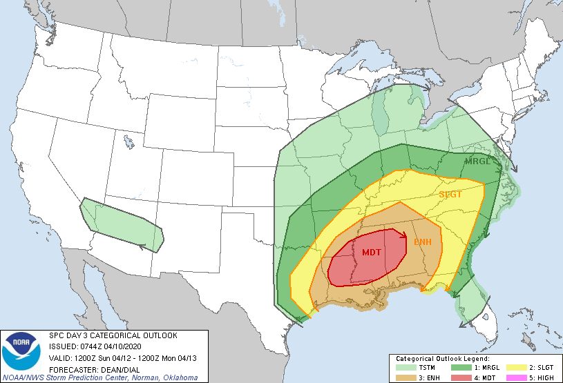
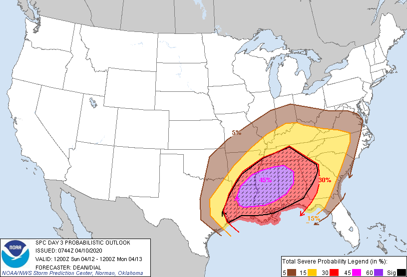
...THERE IS A MODERATE RISK OF SEVERE THUNDERSTORMS FOR
CENTRAL/NORTHERN LOUISIANA...SOUTHEAST
ARKANSAS...MISSISSIPPI...WESTERN/CENTRAL ALABAMA...
...SUMMARY...
An outbreak of severe thunderstorms appears likely Sunday into
Sunday night, with the greatest threat expected from Louisiana
east-northeastward through much of the Southeast and Tennessee
Valley. Strong, long-tracked tornadoes and potentially widespread
damaging wind are possible.
...Synopsis...
The ejecting shortwave trough initially over the southern High
Plains Sunday morning is forecast to move quickly eastward and then
northeastward through the period, as it moves around the periphery
of a deepening longwave trough over the central CONUS. As this
occurs, a surface low will move eastward to the Mississippi Valley
by Sunday afternoon, and then rapidly deepen and move northeastward
into the lower Great Lakes by Monday morning. Very strong mass
response will draw rich low-level moisture northward into portions
of the Southeast.
...East Texas into the Southeast...
Ingredients for a potential severe thunderstorm outbreak still
appear likely to come together Sunday. Moderate to locally strong
destabilization in conjunction with an 80-100 kt midlevel jet and
50-60 kt low-level jet will result in a very favorable environment
for organized convection. Ongoing storms across east TX Sunday
morning will likely spread northeastward with time and become
increasingly surface based as they encounter rapidly increasing
low-level moisture, with additional development possible further
south near the lower MS River valley by late morning. As the
downstream airmass heats and destabilizes, long-track supercells may
evolve out of the morning convection and track northeastward into
portions of MS/AL, with a corresponding risk of strong tornadoes,
large hail, and damaging wind gusts. Some upscale growth is possible
with time, which would result in a corresponding widespread damaging
wind risk, given extremely strong wind fields. Some threat of
damaging wind and a few tornadoes will likely reach portions of the
Carolinas by 12Z Monday.
...Mid MS Valley into the OH Valley...
Destabilization in the vicinity of the primary surface low into the
mid MS Valley/OH Valley is more uncertain, given the potential for
disruptive convection further south. However, favorable wind
profiles and closer proximity to the ejecting shortwave will support
some severe thunderstorm threat in this region as well, with a
conditional risk of all hazards given sufficient destabilization.
..Dean/Dial.. 04/10/2020
CLICK TO GET WUUS03 PTSDY3 PRODUCT
NOTE: THE NEXT DAY 3 OUTLOOK IS SCHEDULED BY 0730Z