Indianapolis, IN...Nashville, TN...Kansas City, MO...Wichita, KS...Louisville, KY...
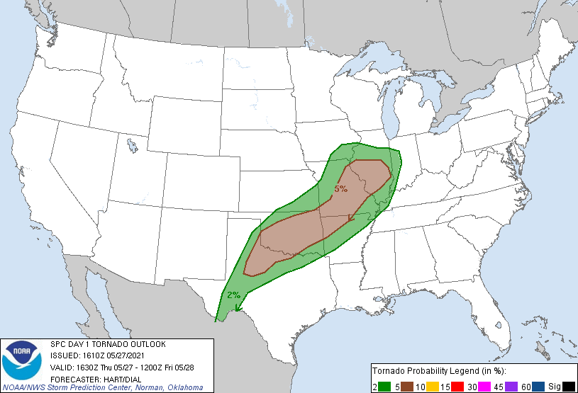
Probabilistic Tornado Graphic
Probability of a tornado within 25 miles of a point. Hatched Area: 10% or greater probability of EF2 - EF5 tornadoes within 25 miles of a point.
Day 1 Tornado Risk
Area (sq. mi.)
Area Pop.
Some Larger Population Centers in Risk Area
5 %
139,896
10,300,031
Oklahoma City, OK...Tulsa, OK...St. Louis, MO...Springfield, MO...Springfield, IL...
2 %
170,789
11,986,634
Fort Worth, TX...Arlington, TX...Plano, TX...Garland, TX...Irving, TX...
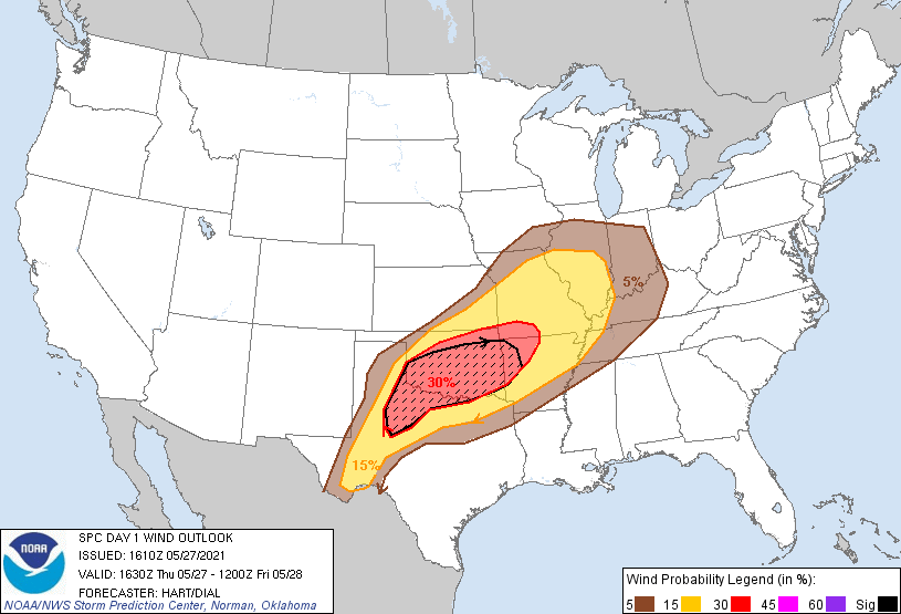
Probabilistic Damaging Wind Graphic
Probability of damaging thunderstorm winds or wind gusts of 50 knots or higher within 25 miles of a point. Hatched Area: 10% of greater probability of wind gusts 65 knots or greater within 25 miles of a point.
Day 1 Wind Risk
Area (sq. mi.)
Area Pop.
Some Larger Population Centers in Risk Area
SIG SEVERE
71,851
4,314,991
Oklahoma City, OK...Tulsa, OK...Norman, OK...Wichita Falls, TX...Lawton, OK...
30 %
94,260
5,591,270
Oklahoma City, OK...Tulsa, OK...Norman, OK...Wichita Falls, TX...Lawton, OK...
Indianapolis, IN...Nashville, TN...Kansas City, MO...Wichita, KS...Louisville, KY...
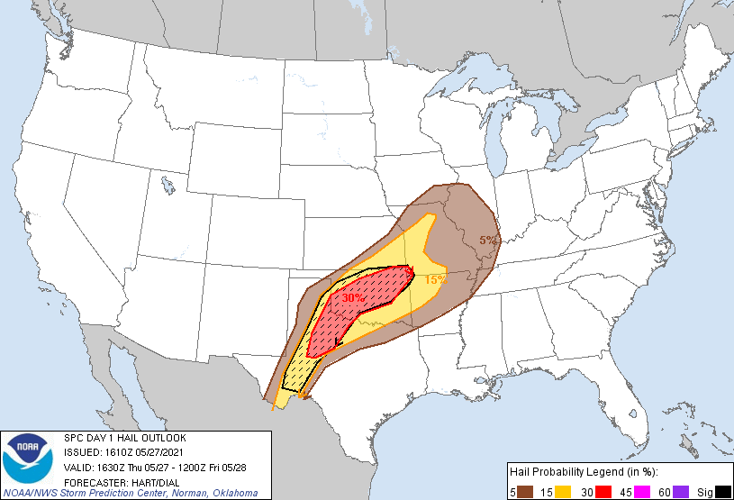
Probabilistic Large Hail Graphic
Probability of hail 1" or larger within 25 miles of a point. Hatched Area: 10% or greater probability of hail 2" or larger within 25 miles of a point.
Day 1 Hail Risk
Area (sq. mi.)
Area Pop.
Some Larger Population Centers in Risk Area
SIG SEVERE
86,663
4,054,249
Oklahoma City, OK...Tulsa, OK...Norman, OK...Midland, TX...Lawton, OK...
30 %
58,245
3,473,275
Oklahoma City, OK...Tulsa, OK...Norman, OK...Lawton, OK...Broken Arrow, OK...
15 %
115,313
4,866,273
Springfield, MO...Abilene, TX...Olathe, KS...Independence, MO...Wichita Falls, TX...
5 %
180,486
17,792,224
Dallas, TX...Memphis, TN...Fort Worth, TX...Kansas City, MO...Arlington, TX...
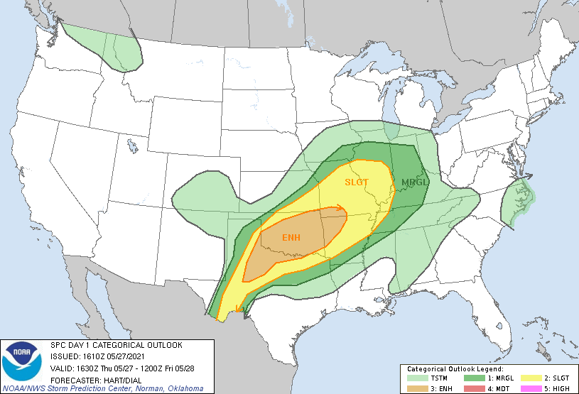
   SPC AC 271610

   Day 1 Convective Outlook
   NWS Storm Prediction Center Norman OK
   1110 AM CDT Thu May 27 2021

   Valid 271630Z - 281200Z

   ...THERE IS AN ENHANCED RISK OF SEVERE THUNDERSTORMS THIS AFTERNOON
   AND EVENING FROM SOUTHWEST MISSOURI AND NORTHWEST ARKANSAS WESTWARD
   INTO PORTIONS OF OKLAHOMA AND TEXAS...

   ...SUMMARY...
   Scattered severe thunderstorms are expected from parts of the
   southern Great Plains into the Ozarks and Mid-Mississippi Valley.
   Significant damaging winds, very large hail, and a few tornadoes are
   possible.

   ...IL to OK...

   A complex convective day is expected across the central/southern
   Plains into the mid MS Valley, with numerous strong to severe
   thunderstorms over a wide area.  Multiple remnant MCV, outflow
   boundaries, and areas of convection from overnight storms extend
   from western IL across MO and southern KS into OK and west TX.
   Morning observed and afternoon forecast soundings show a potent
   thermodynamic environment to the south of these features, with steep
   mid-level lapse rates, rich low-level moisture, little capping
   inversion, and the potential for MLCAPE values of 2500-3500 J/kg.
   This will likely result in rapid thunderstorm development by mid
   afternoon near any subtle surface features, with activity sagging
   southeastward through the evening.  Deep-layer shear is sufficient
   for supercell and bowing structures capable of very large hail and
   corridors of wind damage.  Low-level winds are not particularly
   strong, so tornado potential will likely be isolated and focus along
   outflow boundaries, or be associated with QLCS/bowing features this
   evening.

   ...West TX...
   The dryline is expected to focus this afternoon across west TX, with
   temperatures well into the 90s to the west and dewpoints in the
   upper 60s to the east.  This should be sufficient to eliminate the
   cap and result in isolated supercell thunderstorms this afternoon
   and evening.  Very large hail and damaging winds will be likely with
   those storms that form.

   ..Hart/Dial.. 05/27/2021

   CLICK TO GET WUUS01 PTSDY1 PRODUCT

   NOTE: THE NEXT DAY 1 OUTLOOK IS SCHEDULED BY 2000Z