St. Louis, MO...Springfield, MO...Springfield, IL...Columbia, MO...Fort Smith, AR...
SLIGHT
78,171
6,188,256
Memphis, TN...Little Rock, AR...Evansville, IN...Peoria, IL...Independence, MO...
MARGINAL
107,533
11,082,559
Indianapolis, IN...Kansas City, MO...Omaha, NE...Louisville, KY...Lincoln, NE...
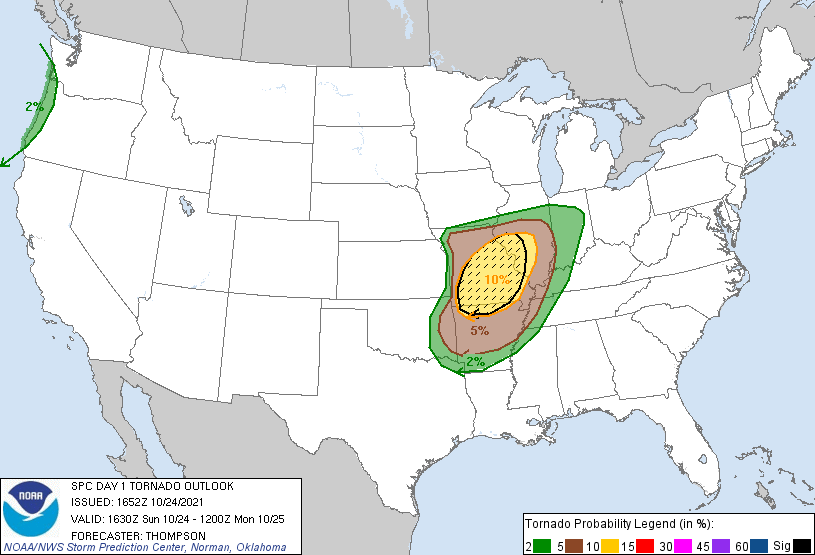
Probabilistic Tornado Graphic
Probability of a tornado within 25 miles of a point. Hatched Area: 10% or greater probability of EF2 - EF5 tornadoes within 25 miles of a point.
Day 1 Tornado Risk
Area (sq. mi.)
Area Pop.
Some Larger Population Centers in Risk Area
SIG SEVERE
50,835
4,843,555
St. Louis, MO...Springfield, MO...Columbia, MO...St. Charles, MO...St. Peters, MO...
10 %
62,428
5,597,317
St. Louis, MO...Springfield, MO...Springfield, IL...Columbia, MO...St. Charles, MO...
5 %
89,009
5,843,794
Memphis, TN...Little Rock, AR...Fort Smith, AR...Decatur, IL...Champaign, IL...
2 %
88,541
8,784,401
Indianapolis, IN...Kansas City, MO...Overland Park, KS...Kansas City, KS...Evansville, IN...
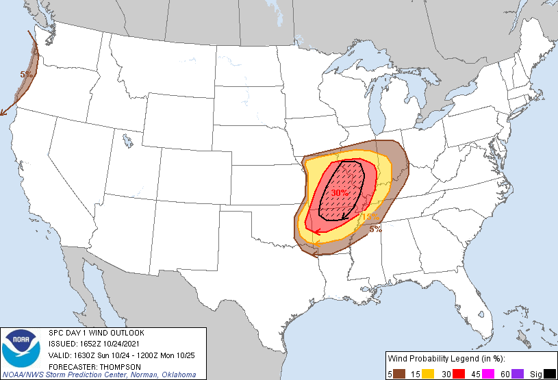
Probabilistic Damaging Wind Graphic
Probability of damaging thunderstorm winds or wind gusts of 50 knots or higher within 25 miles of a point. Hatched Area: 10% of greater probability of wind gusts 65 knots or greater within 25 miles of a point.
Day 1 Wind Risk
Area (sq. mi.)
Area Pop.
Some Larger Population Centers in Risk Area
SIG SEVERE
49,354
4,665,348
St. Louis, MO...Springfield, MO...St. Charles, MO...St. Peters, MO...Florissant, MO...
30 %
98,335
7,860,889
St. Louis, MO...Springfield, MO...Springfield, IL...Columbia, MO...Fort Smith, AR...
15 %
79,334
6,262,573
Memphis, TN...Little Rock, AR...Evansville, IN...Peoria, IL...Independence, MO...
5 %
88,335
9,523,152
Indianapolis, IN...Kansas City, MO...Louisville, KY...Overland Park, KS...Kansas City, KS...
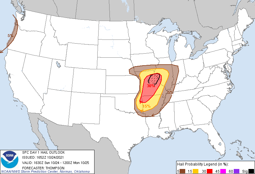
Probabilistic Large Hail Graphic
Probability of hail 1" or larger within 25 miles of a point. Hatched Area: 10% or greater probability of hail 2" or larger within 25 miles of a point.
Day 1 Hail Risk
Area (sq. mi.)
Area Pop.
Some Larger Population Centers in Risk Area
SIG SEVERE
12,010
674,367
Columbia, MO...Quincy, IL...Jefferson City, MO...Hannibal, MO...Moberly, MO...
St. Louis, MO...Little Rock, AR...Springfield, IL...Peoria, IL...Independence, MO...
5 %
121,183
9,762,574
Memphis, TN...Kansas City, MO...Omaha, NE...Lincoln, NE...Overland Park, KS...
SPC AC 241652
Day 1 Convective Outlook CORR 1
NWS Storm Prediction Center Norman OK
1152 AM CDT Sun Oct 24 2021
Valid 241630Z - 251200Z
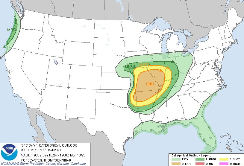
...THERE IS AN ENHANCED RISK OF SEVERE THUNDERSTORMS THIS AFTERNOON
INTO TONIGHT FOR THE OZARKS AND MID MS VALLEY...
CORRECTED FOR POINTS PRODUCT
...SUMMARY...
Scattered severe thunderstorms with damaging wind gusts, large hail
and a couple of strong tornadoes are expected from parts of the
Ozarks into the middle Mississippi Valley this afternoon into
tonight. Isolated damaging gusts and a tornado or two will also be
possible along the Oregon coast.
...Ozarks to Mid MS Valley this afternoon into tonight...
A midlevel shortwave trough over central KS as of late morning will
progress to MO later this afternoon and IL/IN overnight, and will be
preceded by a surface cyclone across northern MO this afternoon into
northern IL/IN tonight. South of the surface cyclone, a cold front
will move eastward/southeastward from eastern KS/OK across MO/IL/AR
through tonight. The focus for severe storms will be along and just
ahead of the cold front, with the surface warm front delineating the
northern extent of the main tornado/wind threat.
Mid 60s boundary-layer dewpoints will continue to spread
north-northeastward in the warm sector from OK/AR to MO/IL through
this evening in advance of the cold front. The moistening will
occur beneath midlevel lapse rates near 8 C/km, and will combine
with daytime heating to support MLCAPE values around 2000 J/kg and
weakening convective inhibition by mid afternoon. Thunderstorm
development is anticipated by 19-21z in broken bands along and 1-2
counties ahead of the cold front (as evidenced by the weak
pre-frontal convection now forming in east/southeast KS), and storms
will move northeastward into the warm front zone in MO and into west
central IL later this afternoon/evening. Additional storm
development will occur southwestward into eastern OK/western AR.
Frontal forcing for ascent typically favors squall line development,
though there is some potential for semi-discrete supercells given
relatively fast storm motions compared to frontal motion, and
substantial cross-frontal deep-layer flow/shear. Long hodographs
(effective bulk shear of 40-50 kt) and some low-level hodograph
curvature (effective SRH 200-300 m2/s2, especially east of the cold
front in the open warm sector) will favor supercells initially with
the potential to produce tornadoes (a few of which could be strong),
in addition to damaging winds and large hail.
The severe threat will transition more to damaging winds by late
evening and early tonight, though supercells will still be possible
into AR, with QLCS mesovortices and some tornado potential farther
north in MO/IL.
...OR coast and vicinity this afternoon...
A deep, occluded cyclone near 46 N and 131 W will move toward
Vancouver, while the associated baroclinic zone moves inland across
the Pacific Northwest coast today. Very strong wind profile/long
hodographs and weak buoyancy close to the coast could sustain an
isolated damaging wind/tornado threat along the coast with
low-topped convection spreading inland, mainly this afternoon.
..Thompson.. 10/24/2021
CLICK TO GET WUUS01 PTSDY1 PRODUCT
NOTE: THE NEXT DAY 1 OUTLOOK IS SCHEDULED BY 2000Z