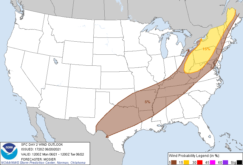
Probability of damaging thunderstorm winds or wind gusts of 50 knots or higher within 25 miles of a point. Hatched Area: 10% of greater probability of wind gusts 65 knots or greater within 25 miles of a point.
SPC AC 201720
Day 2 Convective Outlook
NWS Storm Prediction Center Norman OK
1220 PM CDT Sun Jun 20 2021
Valid 211200Z - 221200Z
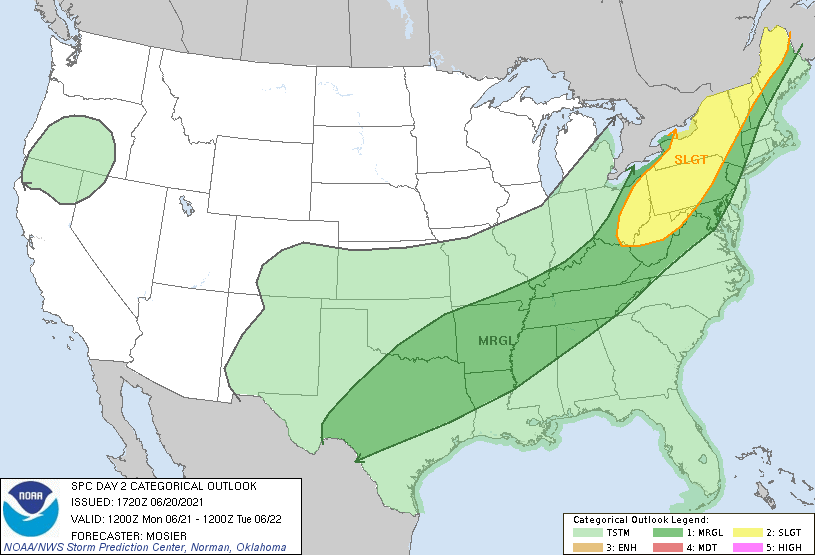
...THERE IS A SLIGHT RISK OF SEVERE THUNDERSTORMS FROM THE UPPER OH
VALLEY INTO THE NORTHEAST STATES...
...SUMMARY...
Isolated to scattered severe thunderstorms should occur Monday from
parts of the Northeast and Mid-Atlantic southwestward into the Ohio
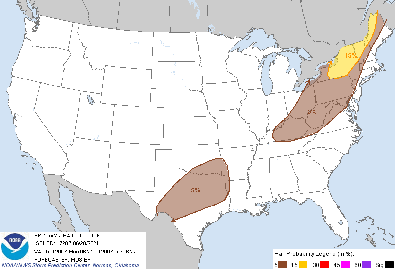
Valley. Damaging wind gusts, severe hail, and perhaps a couple of
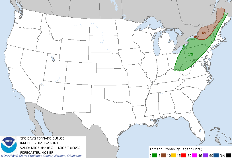
tornadoes all appear possible.
...Synopsis...
Upper troughing is forecast to amplify as it moves eastward from the
northern/central Plains through the Upper/Mid MS Valley and into the
Upper Great Lakes and Middle OH Valley. Enhanced mid-level flow
through the base of this upper trough will gradually strengthen
throughout the day, while also spreading eastward/southeastward into
more of OK/Arklatex, the OH Valley, and Lower Great Lakes.
At the surface, a low initially over the Upper Great Lakes region is
expected to deepen/mature as it ejects quickly northeastward into
Quebec. Expansive cold front attendant to this low will sweep
eastward/southeastward across the southern Plains, mid MS Valley, OH
Valley, and much of the Northeast. This cold front will likely
extend from southern New England southwestward along the central
Appalachians and then back more west-southwestward through the Lower
MS Valley into TX Hill Country early Tuesday morning.
...Northeast into the Upper Ohio Valley...
Mid 60s to low 70s dewpoints are forecast to be in place across the
region ahead of the approaching cold front, supporting at least
moderate instability. Predominantly southerly flow is anticipated
ahead of the front, with some veering possible immediately ahead of
the front. As a result, convergence along the front itself will
likely be modest, but confluence within the broad and moist warm
sector should result in multiple convective bands along and ahead of
the front. Moderate mid-level flow is expected already be in place
over the region by early Monday, with some modest strengthening
possible throughout the day. Resultant vertical shear will support
some more organized storm structures. The more boundary parallel
shear vectors should support bowing line segments as the predominant
storm mode, with an attendant threat for damaging wind gusts as the
primary severe risk. Low-level shear does appear strong enough to
support brief tornadoes with any cells than can remain more
cellular/discrete. Hail could also occur with any more discrete
cells.
...Lower/Middle OH Valley into the Mid-South...
Thermodynamic conditions over this region are similar to those
farther north from the upper OH Valley into the Northeast. However,
the stronger mid-level flow will lag behind the front with storm
structures likely remaining outflow dominant. Storm outflow will
likely augment the front, resulting in a relatively progressive
boundary despite its displacement from the primary low. Progressive
nature of the front coupled with a boundary parallel vertical shear
vector will also result in updraft undercutting and relatively
short-duration updraft. These factors should mitigate the overall
severe risk, although isolated damaging wind gusts are still
possible.
...Arklatex into the southern Plains...
Outflow associated with overnight storms across KS on Sunday will
likely have augmented the front and pushed it southward into OK by
early Monday. Ample low-level moisture will be in place ahead of the
front, contributing to strong instability and the potential for
robust updrafts. However, weak shear should preclude organization
within these storms, resulting in outflow-dominant storm structures.
As the front/composite outflow continues southward, the potential
for damaging wind gusts will likely increase, owing to the strong
heating and steep low-level lapse rates, maximizing across the TX
Hill Country. Higher probabilities may be needed in later outlooks
once the frontal position becomes more apparent.
..Mosier.. 06/20/2021
CLICK TO GET WUUS02 PTSDY2 PRODUCT
NOTE: THE NEXT DAY 2 OUTLOOK IS SCHEDULED BY 0600Z